Indang–Alfonso Road
| Indang–Alfonso Road | |
|---|---|
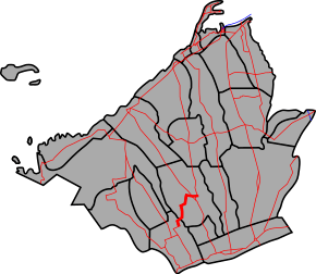 The route alignment of Indang–Alfonso Road | |
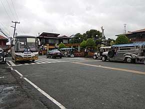 A segment of the road in Indang | |
| Route information | |
| Maintained by Department of Public Works and Highways (DPWH) - Cavite 2nd District Engineering Office | |
| Length | 18.51 km (11.50 mi) |
| Major junctions | |
| East end |
|
| Southwest end |
|
| Location | |
| Provinces | Cavite |
| Towns | Indang, Alfonso |
| Highway system | |
|
Roads in the Philippines | |
The Indang–Alfonso Road is a 18.51-kilometre (11.50 mi), two-to-five lane, tertiary road that connects the municipalities of Indang and Alfonso in Cavite, Philippines.[1]
Intersections
The entire route is located in Cavite.
| City/Municipality | km[2] | mi | Destinations | Notes | |
|---|---|---|---|---|---|
| Indang | 55.530 | 34.505 | Western Terminus. Kilometre number reverses. | ||
| 57.592 | 35.786 | Bimambangan Bridge | |||
| 58.095 | 36.099 | Kaytambog Bridge | |||
| 58.735 | 36.496 | Lulungisan Bridge | |||
| 61.163 | 38.005 | Banaba Bridge | |||
| 62.816 | 39.032 | Lipa Bridge | |||
| 64.976 | 40.374 | Catmon Bridge | |||
| Indang–Alfonso boundary | 66.368 | 41.239 | Pajo Bridge | ||
| Alfonso | 74.040 | 46.006 | Southern Terminus. | ||
| 1.000 mi = 1.609 km; 1.000 km = 0.621 mi | |||||
References
- ↑ "Cavite". www.dpwh.gov.ph. Retrieved 2018-01-09.
- ↑ "Road and Bridge Inventory". www.dpwh.gov.ph. Retrieved 2018-01-20.
External links
| Expressways |
| ||||||||
|---|---|---|---|---|---|---|---|---|---|
| National roads |
| ||||||||
| Arterial Routes |
| ||||||||
This article is issued from
Wikipedia.
The text is licensed under Creative Commons - Attribution - Sharealike.
Additional terms may apply for the media files.