Trece Martires–Indang Road
| ||||
|---|---|---|---|---|
| Trece–Indang Road | ||||
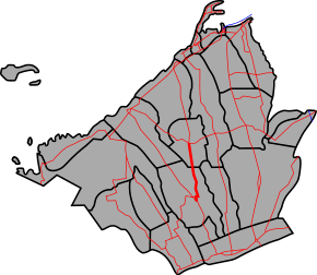 Trece Martires–Indang Road highlighted in red | ||||
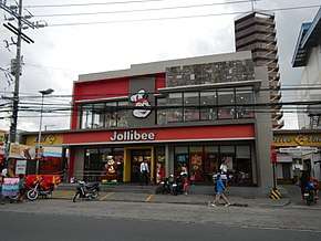 A Jollibee outlet along Trece Martires–Indang Road. | ||||
| Route information | ||||
| Maintained by Department of Public Works and Highways (DPWH) - Cavite 2nd District Engineering Office | ||||
| Length | 12.015 km (7.466 mi) | |||
| Existed | 1970s–present | |||
| Component highways | ||||
| Major junctions | ||||
| North end |
| |||
| South end |
| |||
| Location | ||||
| Provinces | Cavite | |||
| Major cities | Trece Martires | |||
| Towns | Indang | |||
| Highway system | ||||
|
Roads in the Philippines
| ||||
.svg.png)

The Trece Martires–Indang Road (also known as Trece–Indang Road) is a two-to-four lane, 12.015-kilometre (7.466 mi) secondary road in Cavite, Philippines.[1][2][3] It connects the city of Trece Martires and the municipality of Indang, and the fastest way from Trece Martires to Tagaytay City.
The road is mostly paved with asphalt, while some other parts are currently being widened with concrete.[4] It is one of the most busiest roads in Indang. The entire road is designated as the National Route 404 (N404) of the Philippine highway network.
Intersections
The entire route is located in Cavite. Intersections are numbered by kilometre post, with Rizal Park in Manila designated as kilometre 0.
| City/Municipality | km[5] | mi | Destinations | Notes | |
|---|---|---|---|---|---|
| Trece Martires | 47.148 | 29.296 | Northern Terminus. Continuation north as Tanza–Trece Martires Road | ||
| 48.000 | 29.826 | Route 404 reassurance sign. | |||
| Trece Martires–Indang boundary | 51.622 | 32.076 | Cavite 1st District Engineering Office–Cavite 2nd District Engineering Office highway boundary | ||
| Indang | 54.662 | 33.965 | Alulod Bridge | ||
| 56.000 | 34.797 | Route 404 reassurance sign. | |||
| 57.121 | 35.493 | Saluysoy Bridge | |||
| 57.530 | 35.747 | Indang–Alfonso Road – Naic, Alfonso, Maragondon | No right turn for Public Utility Buses. Unlined Intersection. | ||
| 59.137 | 36.746 | Southern Terminus. | |||
| 1.000 mi = 1.609 km; 1.000 km = 0.621 mi | |||||
References
- ↑ "Declaring Trece Martires City - Indang Road in Trece Martires City as National Road. | Department of Public Works and Highways". www.dpwh.gov.ph. Retrieved 2018-01-08.
- ↑ "Cavite 2nd". www.dpwh.gov.ph. Retrieved 2018-01-09.
- ↑ "Cavite". www.dpwh.gov.ph. Retrieved 2018-01-09.
- ↑ "Department of Public Works and Highways" (PDF). www.dpwh.gov.ph. Retrieved 2018-01-09.
- ↑ "Road and Bridge Inventory". www.dpwh.gov.ph. Retrieved 2018-01-20.
External links
| Expressways |
| ||||||||
|---|---|---|---|---|---|---|---|---|---|
| National roads |
| ||||||||
| Arterial Routes |
| ||||||||
This article is issued from
Wikipedia.
The text is licensed under Creative Commons - Attribution - Sharealike.
Additional terms may apply for the media files.