Serverette
| Serverette | ||
|---|---|---|
| Commune | ||
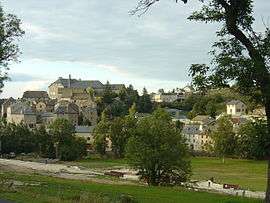 A general view of Serverette | ||
| ||
 Serverette Location within Occitanie region  Serverette | ||
| Coordinates: 44°42′18″N 3°23′12″E / 44.70500°N 3.3867°ECoordinates: 44°42′18″N 3°23′12″E / 44.70500°N 3.3867°E | ||
| Country | France | |
| Region | Occitanie | |
| Department | Lozère | |
| Arrondissement | Mende | |
| Canton | Saint-Alban-sur-Limagnole | |
| Intercommunality | Terres d'Apcher | |
| Government | ||
| • Mayor (2008–2014) | Jean Bonnet[1] | |
| Area1 | 17.35 km2 (6.70 sq mi) | |
| Population (1999)2 | 290 | |
| • Density | 17/km2 (43/sq mi) | |
| Time zone | UTC+1 (CET) | |
| • Summer (DST) | UTC+2 (CEST) | |
| INSEE/Postal code | 48188 /48700 | |
| Elevation |
959–1,106 m (3,146–3,629 ft) (avg. 976 m or 3,202 ft) | |
|
1 French Land Register data, which excludes lakes, ponds, glaciers > 1 km2 (0.386 sq mi or 247 acres) and river estuaries. 2 Population without double counting: residents of multiple communes (e.g., students and military personnel) only counted once. | ||

Serverette is a commune in the Lozère department in southern France.
See also
References
- ↑ Site du conseil général de la Lozère Archived 2009-04-22 at the Wayback Machine.
| Wikimedia Commons has media related to Serverette. |
This article is issued from
Wikipedia.
The text is licensed under Creative Commons - Attribution - Sharealike.
Additional terms may apply for the media files.