Fraissinet-de-Fourques
| Fraissinet-de-Fourques | |
|---|---|
| Commune | |
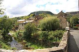 A view from the bridge over the river in Fraissinet-de-Fourques | |
 Fraissinet-de-Fourques Location within Occitanie region  Fraissinet-de-Fourques | |
| Coordinates: 44°12′58″N 3°32′23″E / 44.2161°N 3.5397°ECoordinates: 44°12′58″N 3°32′23″E / 44.2161°N 3.5397°E | |
| Country | France |
| Region | Occitanie |
| Department | Lozère |
| Arrondissement | Florac |
| Canton | Le Collet-de-Dèze |
| Intercommunality | Vallée de la Jonte |
| Government | |
| • Mayor (2008–2014) | Albert Clément[1] |
| Area1 | 24.30 km2 (9.38 sq mi) |
| Population (1999)2 | 67 |
| • Density | 2.8/km2 (7.1/sq mi) |
| Time zone | UTC+1 (CET) |
| • Summer (DST) | UTC+2 (CEST) |
| INSEE/Postal code | 48065 /48400 |
| Elevation |
660–1,343 m (2,165–4,406 ft) (avg. 740 m or 2,430 ft) |
|
1 French Land Register data, which excludes lakes, ponds, glaciers > 1 km2 (0.386 sq mi or 247 acres) and river estuaries. 2 Population without double counting: residents of multiple communes (e.g., students and military personnel) only counted once. | |
Fraissinet-de-Fourques is a commune in the Lozère department in southern France.
See also
References
- ↑ Site du conseil général de la Lozère Archived 2008-07-25 at the Wayback Machine.
| Wikimedia Commons has media related to Fraissinet-de-Fourques. |
This article is issued from
Wikipedia.
The text is licensed under Creative Commons - Attribution - Sharealike.
Additional terms may apply for the media files.