Grandrieu
| Grandrieu | ||
|---|---|---|
| Commune | ||
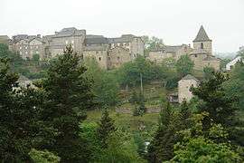 Gandrieu from across the valley | ||
| ||
 Grandrieu Location within Occitanie region  Grandrieu | ||
| Coordinates: 44°47′07″N 3°38′02″E / 44.7853°N 3.6339°ECoordinates: 44°47′07″N 3°38′02″E / 44.7853°N 3.6339°E | ||
| Country | France | |
| Region | Occitanie | |
| Department | Lozère | |
| Arrondissement | Mende | |
| Canton | Grandrieu | |
| Intercommunality | Margeride Est | |
| Government | ||
| • Mayor (2008–2014) | Jean-Claude Laroche[1] | |
| Area1 | 65.37 km2 (25.24 sq mi) | |
| Population (1999)2 | 773 | |
| • Density | 12/km2 (31/sq mi) | |
| Time zone | UTC+1 (CET) | |
| • Summer (DST) | UTC+2 (CEST) | |
| INSEE/Postal code | 48070 /48600 | |
| Elevation |
867–1,317 m (2,844–4,321 ft) (avg. 1,160 m or 3,810 ft) | |
|
1 French Land Register data, which excludes lakes, ponds, glaciers > 1 km2 (0.386 sq mi or 247 acres) and river estuaries. 2 Population without double counting: residents of multiple communes (e.g., students and military personnel) only counted once. | ||

Grandrieu is a village and commune in the Lozère department in southern France.
Geography
The Chapeauroux forms parts of the commune's north-eastern border.
See also
References
- ↑ Site du conseil général de la Lozère Archived 2008-10-24 at the Wayback Machine.
| Wikimedia Commons has media related to Grandrieu. |
This article is issued from
Wikipedia.
The text is licensed under Creative Commons - Attribution - Sharealike.
Additional terms may apply for the media files.