Prunières, Lozère
| Prunières | ||
|---|---|---|
| Commune | ||
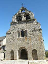 The Church of Saint-Caprais, in Prunières | ||
| ||
 Prunières Location within Occitanie region  Prunières | ||
| Coordinates: 44°49′38″N 3°20′35″E / 44.8272°N 3.3431°ECoordinates: 44°49′38″N 3°20′35″E / 44.8272°N 3.3431°E | ||
| Country | France | |
| Region | Occitanie | |
| Department | Lozère | |
| Arrondissement | Mende | |
| Canton | Saint-Chély-d'Apcher | |
| Government | ||
| • Mayor (2001–2008) | Roland Odoul | |
| Area1 | 13.09 km2 (5.05 sq mi) | |
| Population (1999)2 | 175 | |
| • Density | 13/km2 (35/sq mi) | |
| Time zone | UTC+1 (CET) | |
| • Summer (DST) | UTC+2 (CEST) | |
| INSEE/Postal code | 48121 /48200 | |
| Elevation |
868–1,121 m (2,848–3,678 ft) (avg. 1,030 m or 3,380 ft) | |
|
1 French Land Register data, which excludes lakes, ponds, glaciers > 1 km2 (0.386 sq mi or 247 acres) and river estuaries. 2 Population without double counting: residents of multiple communes (e.g., students and military personnel) only counted once. | ||
.svg.png)
Prunières (Occitan: Prunièiras) is a commune in the Lozère department in southern France.
See also
| Wikimedia Commons has media related to Prunières, Lozère. |
This article is issued from
Wikipedia.
The text is licensed under Creative Commons - Attribution - Sharealike.
Additional terms may apply for the media files.