Sainte-Hélène, Lozère
| Sainte-Hélène | |
|---|---|
| Commune | |
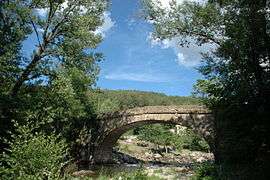 The bridge over the River Lot, in Sainte-Hélène | |
 Sainte-Hélène Location within Occitanie region  Sainte-Hélène | |
| Coordinates: 44°31′12″N 3°36′13″E / 44.52000°N 3.6036°ECoordinates: 44°31′12″N 3°36′13″E / 44.52000°N 3.6036°E | |
| Country | France |
| Region | Occitanie |
| Department | Lozère |
| Arrondissement | Mende |
| Canton | Grandrieu |
| Intercommunality | Goulet-Mont Lozère |
| Government | |
| • Mayor (2014–2020) | Gérard Bonicel |
| Area1 | 6.73 km2 (2.60 sq mi) |
| Population (2014)2 | 81 |
| • Density | 12/km2 (31/sq mi) |
| Time zone | UTC+1 (CET) |
| • Summer (DST) | UTC+2 (CEST) |
| INSEE/Postal code | 48157 /48190 |
| Elevation |
793–1,212 m (2,602–3,976 ft) (avg. 900 m or 3,000 ft) |
|
1 French Land Register data, which excludes lakes, ponds, glaciers > 1 km2 (0.386 sq mi or 247 acres) and river estuaries. 2 Population without double counting: residents of multiple communes (e.g., students and military personnel) only counted once. | |
Sainte-Hélène is a commune in the Lozère department in southern France.[1]
Demography
| Year | 1962 | 1968 | 1975 | 1982 | 1990 | 1999 |
|---|---|---|---|---|---|---|
| Population | 75 | 54 | 44 | 44 | 47 | 52 |
See also
References
External links
| Wikimedia Commons has media related to Sainte-Hélène (Lozère). |
This article is issued from
Wikipedia.
The text is licensed under Creative Commons - Attribution - Sharealike.
Additional terms may apply for the media files.