Saint-Alban-sur-Limagnole
| Saint-Alban-sur-Limagnole | ||
|---|---|---|
| Commune | ||
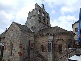 The church of Saint-Alban-sur-Limagnole | ||
| ||
 Saint-Alban-sur-Limagnole Location within Occitanie region  Saint-Alban-sur-Limagnole | ||
| Coordinates: 44°46′55″N 3°23′21″E / 44.7819°N 3.3892°ECoordinates: 44°46′55″N 3°23′21″E / 44.7819°N 3.3892°E | ||
| Country | France | |
| Region | Occitanie | |
| Department | Lozère | |
| Arrondissement | Mende | |
| Canton | Saint-Alban-sur-Limagnole | |
| Intercommunality | Terres d'Apcher | |
| Government | ||
| • Mayor (2008–2014) | Jean-Paul Bonhomme | |
| Area1 | 51.23 km2 (19.78 sq mi) | |
| Population (1999)2 | 1,598 | |
| • Density | 31/km2 (81/sq mi) | |
| Time zone | UTC+1 (CET) | |
| • Summer (DST) | UTC+2 (CEST) | |
| INSEE/Postal code | 48132 /48120 | |
| Elevation |
872–1,305 m (2,861–4,281 ft) (avg. 950 m or 3,120 ft) | |
|
1 French Land Register data, which excludes lakes, ponds, glaciers > 1 km2 (0.386 sq mi or 247 acres) and river estuaries. 2 Population without double counting: residents of multiple communes (e.g., students and military personnel) only counted once. | ||

Saint-Alban-sur-Limagnole (Occitan: Sench Aubanh) is a commune in the Lozère department in southern France.
See also
References
| Wikimedia Commons has media related to Saint-Alban-sur-Limagnole. |
This article is issued from
Wikipedia.
The text is licensed under Creative Commons - Attribution - Sharealike.
Additional terms may apply for the media files.