Moissac-Vallée-Française
| Moissac-Vallée-Française | ||
|---|---|---|
| Commune | ||
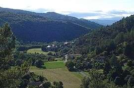 A view of Moissac's valley, toward the north from the old castle | ||
| ||
 Moissac-Vallée-Française Location within Occitanie region  Moissac-Vallée-Française | ||
| Coordinates: 44°09′50″N 3°47′07″E / 44.1639°N 3.7853°ECoordinates: 44°09′50″N 3°47′07″E / 44.1639°N 3.7853°E | ||
| Country | France | |
| Region | Occitanie | |
| Department | Lozère | |
| Arrondissement | Florac | |
| Canton | Le Collet-de-Dèze | |
| Intercommunality | Cévenne des Hauts Gardons | |
| Government | ||
| • Mayor (2008–2014) | Pierre Fesquet[1] | |
| Area1 | 27.05 km2 (10.44 sq mi) | |
| Population (1999)2 | 228 | |
| • Density | 8.4/km2 (22/sq mi) | |
| Time zone | UTC+1 (CET) | |
| • Summer (DST) | UTC+2 (CEST) | |
| INSEE/Postal code | 48097 /48110 | |
| Elevation |
256–768 m (840–2,520 ft) (avg. 300 m or 980 ft) | |
|
1 French Land Register data, which excludes lakes, ponds, glaciers > 1 km2 (0.386 sq mi or 247 acres) and river estuaries. 2 Population without double counting: residents of multiple communes (e.g., students and military personnel) only counted once. | ||

Moissac-Vallée-Française is a commune in the Lozère département in southern France.
See also
References
- ↑ Site du conseil général de la Lozère Archived 2008-10-24 at the Wayback Machine.
| Wikimedia Commons has media related to Moissac-Vallée-Française. |
This article is issued from
Wikipedia.
The text is licensed under Creative Commons - Attribution - Sharealike.
Additional terms may apply for the media files.