Les Hermaux
| Les Hermaux | |
|---|---|
| Commune | |
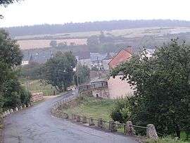 The village of Les Hermaux | |
 Les Hermaux Location within Occitanie region  Les Hermaux | |
| Coordinates: 44°31′01″N 3°07′57″E / 44.5169°N 3.13250°ECoordinates: 44°31′01″N 3°07′57″E / 44.5169°N 3.13250°E | |
| Country | France |
| Region | Occitanie |
| Department | Lozère |
| Arrondissement | Mende |
| Canton | Aumont-Aubrac |
| Intercommunality | Aubrac-Lot-Causse |
| Government | |
| • Mayor (2008–2014) | Jean-Louis Gély[1] |
| Area1 | 17.59 km2 (6.79 sq mi) |
| Population (1999)2 | 111 |
| • Density | 6.3/km2 (16/sq mi) |
| Time zone | UTC+1 (CET) |
| • Summer (DST) | UTC+2 (CEST) |
| INSEE/Postal code | 48073 /48340 |
| Elevation |
589–1,361 m (1,932–4,465 ft) (avg. 1,050 m or 3,440 ft) |
|
1 French Land Register data, which excludes lakes, ponds, glaciers > 1 km2 (0.386 sq mi or 247 acres) and river estuaries. 2 Population without double counting: residents of multiple communes (e.g., students and military personnel) only counted once. | |
Les Hermaux is a commune in the Lozère department in southern France.
See also
References
- ↑ Site du conseil général de la Lozère Archived 2008-10-24 at the Wayback Machine.
| Wikimedia Commons has media related to Les Hermaux. |
This article is issued from
Wikipedia.
The text is licensed under Creative Commons - Attribution - Sharealike.
Additional terms may apply for the media files.