Balsièges
| Balsièges | ||
|---|---|---|
| Commune | ||
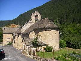 The church in Balsièges | ||
| ||
 Balsièges Location within Occitanie region  Balsièges | ||
| Coordinates: 44°28′53″N 3°27′30″E / 44.4814°N 3.4583°ECoordinates: 44°28′53″N 3°27′30″E / 44.4814°N 3.4583°E | ||
| Country | France | |
| Region | Occitanie | |
| Department | Lozère | |
| Arrondissement | Mende | |
| Canton | Chirac | |
| Intercommunality | Valdonnez | |
| Government | ||
| • Mayor (2008–2014) | Philippe Martin | |
| Area1 | 32.88 km2 (12.70 sq mi) | |
| Population (2009)2 | 521 | |
| • Density | 16/km2 (41/sq mi) | |
| Time zone | UTC+1 (CET) | |
| • Summer (DST) | UTC+2 (CEST) | |
| INSEE/Postal code | 48016 /48000 | |
| Elevation |
652–1,093 m (2,139–3,586 ft) (avg. 685 m or 2,247 ft) | |
|
1 French Land Register data, which excludes lakes, ponds, glaciers > 1 km2 (0.386 sq mi or 247 acres) and river estuaries. 2 Population without double counting: residents of multiple communes (e.g., students and military personnel) only counted once. | ||

Balsièges is a commune in the Lozère department in southern France.
Population
| Historical population | ||
|---|---|---|
| Year | Pop. | ±% |
| 1793 | 502 | — |
| 1800 | 421 | −16.1% |
| 1806 | 779 | +85.0% |
| 1821 | 711 | −8.7% |
| 1831 | 668 | −6.0% |
| 1836 | 671 | +0.4% |
| 1841 | 682 | +1.6% |
| 1846 | 721 | +5.7% |
| 1851 | 712 | −1.2% |
| 1856 | 672 | −5.6% |
| 1861 | 631 | −6.1% |
| 1866 | 614 | −2.7% |
| 1872 | 566 | −7.8% |
| 1876 | 611 | +8.0% |
| 1881 | 794 | +30.0% |
| 1886 | 611 | −23.0% |
| 1891 | 540 | −11.6% |
| 1896 | 543 | +0.6% |
| 1901 | 489 | −9.9% |
| 1906 | 450 | −8.0% |
| 1911 | 477 | +6.0% |
| 1921 | 339 | −28.9% |
| 1926 | 332 | −2.1% |
| 1931 | 327 | −1.5% |
| 1936 | 349 | +6.7% |
| 1946 | 344 | −1.4% |
| 1954 | 296 | −14.0% |
| 1962 | 328 | +10.8% |
| 1968 | 365 | +11.3% |
| 1975 | 352 | −3.6% |
| 1982 | 313 | −11.1% |
| 1990 | 428 | +36.7% |
| 1999 | 508 | +18.7% |
| 2006 | 513 | +1.0% |
| 2009 | 521 | +1.6% |
See also
References
| Wikimedia Commons has media related to Balsièges. |
This article is issued from
Wikipedia.
The text is licensed under Creative Commons - Attribution - Sharealike.
Additional terms may apply for the media files.