Pied-de-Borne
| Pied-de-Borne | ||
|---|---|---|
| Commune | ||
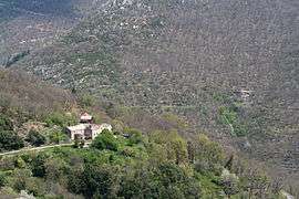 The hamlet of Guinebaldès, in Pied-de-Borne | ||
| ||
 Pied-de-Borne Location within Occitanie region  Pied-de-Borne | ||
| Coordinates: 44°28′34″N 3°59′08″E / 44.4761°N 3.9856°ECoordinates: 44°28′34″N 3°59′08″E / 44.4761°N 3.9856°E | ||
| Country | France | |
| Region | Occitanie | |
| Department | Lozère | |
| Arrondissement | Mende | |
| Canton | Saint-Étienne-du-Valdonnez | |
| Intercommunality | Villefort | |
| Government | ||
| • Mayor (2008–2014) | Christian Masméjean[1] | |
| Area1 | 27.89 km2 (10.77 sq mi) | |
| Population (1999)2 | 197 | |
| • Density | 7.1/km2 (18/sq mi) | |
| Time zone | UTC+1 (CET) | |
| • Summer (DST) | UTC+2 (CEST) | |
| INSEE/Postal code | 48015 /48800 | |
| Elevation |
276–960 m (906–3,150 ft) (avg. 450 m or 1,480 ft) | |
|
1 French Land Register data, which excludes lakes, ponds, glaciers > 1 km2 (0.386 sq mi or 247 acres) and river estuaries. 2 Population without double counting: residents of multiple communes (e.g., students and military personnel) only counted once. | ||

Pied-de-Borne is a commune in the Lozère département in southern France.
Geography
The commune is traversed by the river Chassezac.
See also
References
| Wikimedia Commons has media related to Pied-de-Borne. |
This article is issued from
Wikipedia.
The text is licensed under Creative Commons - Attribution - Sharealike.
Additional terms may apply for the media files.