Saint-Pierre-le-Vieux, Lozère
| Saint-Pierre-le-Vieux | |
|---|---|
| Commune | |
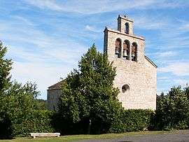 Church of Vareilles, in Saint-Pierre-le-Vieux | |
 Saint-Pierre-le-Vieux Location within Occitanie region  Saint-Pierre-le-Vieux | |
| Coordinates: 44°50′53″N 3°18′33″E / 44.8481°N 3.3092°ECoordinates: 44°50′53″N 3°18′33″E / 44.8481°N 3.3092°E | |
| Country | France |
| Region | Occitanie |
| Department | Lozère |
| Arrondissement | Mende |
| Canton | Saint-Chély-d'Apcher |
| Intercommunality | Terres d'Apcher |
| Government | |
| • Mayor (2008–2014) | Michel Larguier |
| Area1 | 15.55 km2 (6.00 sq mi) |
| Population (1999)2 | 241 |
| • Density | 15/km2 (40/sq mi) |
| Time zone | UTC+1 (CET) |
| • Summer (DST) | UTC+2 (CEST) |
| INSEE/Postal code | 48177 /48200 |
| Elevation |
840–1,090 m (2,760–3,580 ft) (avg. 950 m or 3,120 ft) |
|
1 French Land Register data, which excludes lakes, ponds, glaciers > 1 km2 (0.386 sq mi or 247 acres) and river estuaries. 2 Population without double counting: residents of multiple communes (e.g., students and military personnel) only counted once. | |
Saint-Pierre-le-Vieux is a commune in the Lozère department in southern France.
See also
References
| Wikimedia Commons has media related to Saint-Pierre-le-Vieux (Lozère). |
This article is issued from
Wikipedia.
The text is licensed under Creative Commons - Attribution - Sharealike.
Additional terms may apply for the media files.