Grèzes, Lozère
| Grèzes | |
|---|---|
| Commune | |
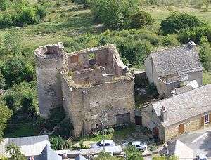 The château of Grèzes, seen from the Truc de Grèzes | |
 Grèzes Location within Occitanie region  Grèzes | |
| Coordinates: 44°30′50″N 3°20′21″E / 44.5139°N 3.3392°ECoordinates: 44°30′50″N 3°20′21″E / 44.5139°N 3.3392°E | |
| Country | France |
| Region | Occitanie |
| Department | Lozère |
| Arrondissement | Mende |
| Canton | Chirac |
| Intercommunality | Gévaudan |
| Government | |
| • Mayor (2008–2014) | Patricia Bremond[1] |
| Area1 | 16.21 km2 (6.26 sq mi) |
| Population (1999)2 | 245 |
| • Density | 15/km2 (39/sq mi) |
| Time zone | UTC+1 (CET) |
| • Summer (DST) | UTC+2 (CEST) |
| INSEE/Postal code | 48072 /48100 |
| Elevation |
709–1,032 m (2,326–3,386 ft) (avg. 890 m or 2,920 ft) |
|
1 French Land Register data, which excludes lakes, ponds, glaciers > 1 km2 (0.386 sq mi or 247 acres) and river estuaries. 2 Population without double counting: residents of multiple communes (e.g., students and military personnel) only counted once. | |
Grèzes is a commune in the Lozère department in southern France.
See also
References
- ↑ Site du conseil général de la Lozère Archived 2008-10-24 at the Wayback Machine.
| Wikimedia Commons has media related to Grèzes (Lozère). |
This article is issued from
Wikipedia.
The text is licensed under Creative Commons - Attribution - Sharealike.
Additional terms may apply for the media files.