Mas-Saint-Chély
| Mas-Saint-Chély | |
|---|---|
| Commune | |
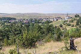 Mas-Saint-Chely on Causse Méjean | |
 Mas-Saint-Chély Location within Occitanie region  Mas-Saint-Chély | |
| Coordinates: 44°18′35″N 3°23′48″E / 44.3097°N 3.3967°ECoordinates: 44°18′35″N 3°23′48″E / 44.3097°N 3.3967°E | |
| Country | France |
| Region | Occitanie |
| Department | Lozère |
| Arrondissement | Florac |
| Canton | Florac |
| Intercommunality | Gorges du Tarn et des Grands Causses |
| Government | |
| • Mayor (2008–2014) | Gérard Mourgues[1] |
| Area1 | 56.81 km2 (21.93 sq mi) |
| Population (1999)2 | 109 |
| • Density | 1.9/km2 (5.0/sq mi) |
| Time zone | UTC+1 (CET) |
| • Summer (DST) | UTC+2 (CEST) |
| INSEE/Postal code | 48141 /48210 |
| Elevation |
800–1,156 m (2,625–3,793 ft) (avg. 450 m or 1,480 ft) |
|
1 French Land Register data, which excludes lakes, ponds, glaciers > 1 km2 (0.386 sq mi or 247 acres) and river estuaries. 2 Population without double counting: residents of multiple communes (e.g., students and military personnel) only counted once. | |
Mas-Saint-Chély is a commune in the Lozère department in southern France.
See also
References
- ↑ Site du conseil général de la Lozère Archived 2008-10-24 at the Wayback Machine.
| Wikimedia Commons has media related to Mas-Saint-Chély. |
This article is issued from
Wikipedia.
The text is licensed under Creative Commons - Attribution - Sharealike.
Additional terms may apply for the media files.