Fontans
| Fontans | |
|---|---|
| Commune | |
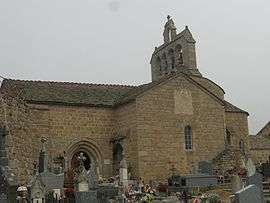 The parish church of Saint-Pierre, in Fontans | |
 Fontans Location within Occitanie region  Fontans | |
| Coordinates: 44°44′23″N 3°23′15″E / 44.7397°N 3.38750°ECoordinates: 44°44′23″N 3°23′15″E / 44.7397°N 3.38750°E | |
| Country | France |
| Region | Occitanie |
| Department | Lozère |
| Arrondissement | Mende |
| Canton | Saint-Alban-sur-Limagnole |
| Intercommunality | Terres d'Apcher |
| Government | |
| • Mayor (2014–2020) | Jean-Paul Vanel[1] |
| Area1 | 33.90 km2 (13.09 sq mi) |
| Population (2012)2 | 213 |
| • Density | 6.3/km2 (16/sq mi) |
| Time zone | UTC+1 (CET) |
| • Summer (DST) | UTC+2 (CEST) |
| INSEE/Postal code | 48063 /48700 |
| Elevation |
910–1,123 m (2,986–3,684 ft) (avg. 1,000 m or 3,300 ft) |
|
1 French Land Register data, which excludes lakes, ponds, glaciers > 1 km2 (0.386 sq mi or 247 acres) and river estuaries. 2 Population without double counting: residents of multiple communes (e.g., students and military personnel) only counted once. | |
Fontans is a commune in the Lozère department in southern France.
Its inhabitants are called Fontanains.[2]
Personalities
- Francis Bestion, born in Fontans in 1957, was vicar general of the Diocese of Mende and has been Bishop of Tulle since December 2013.
See also
References
- ↑ Site du conseil général de la Lozère Archived 2009-04-22 at the Wayback Machine.
- ↑ Gentilé on the web site www.habitants.fr. Accessed 28 December 2015.
| Wikimedia Commons has media related to Fontans. |
This article is issued from
Wikipedia.
The text is licensed under Creative Commons - Attribution - Sharealike.
Additional terms may apply for the media files.