Montbel, Lozère
| Montbel | |
|---|---|
| Commune | |
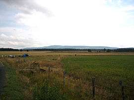 The plain of Montbel | |
 Montbel Location within Occitanie region  Montbel | |
| Coordinates: 44°35′34″N 3°42′59″E / 44.5928°N 3.7164°ECoordinates: 44°35′34″N 3°42′59″E / 44.5928°N 3.7164°E | |
| Country | France |
| Region | Occitanie |
| Department | Lozère |
| Arrondissement | Mende |
| Canton | Grandrieu |
| Intercommunality | canton de Châteauneuf-de-Randon |
| Government | |
| • Mayor (2008–2014) | William Moulin[1] |
| Area1 | 22.87 km2 (8.83 sq mi) |
| Population (1999)2 | 139 |
| • Density | 6.1/km2 (16/sq mi) |
| Time zone | UTC+1 (CET) |
| • Summer (DST) | UTC+2 (CEST) |
| INSEE/Postal code | 48100 /48170 |
| Elevation |
1,186–1,436 m (3,891–4,711 ft) (avg. 1,220 m or 4,000 ft) |
|
1 French Land Register data, which excludes lakes, ponds, glaciers > 1 km2 (0.386 sq mi or 247 acres) and river estuaries. 2 Population without double counting: residents of multiple communes (e.g., students and military personnel) only counted once. | |
Montbel (Montbèl in Occitan) is a commune in the Lozère département in southern France.
See also
References
| Wikimedia Commons has media related to Montbel, Lozère. |
This article is issued from
Wikipedia.
The text is licensed under Creative Commons - Attribution - Sharealike.
Additional terms may apply for the media files.