Saint-Laurent-de-Veyrès
| Saint-Laurent-de-Veyrès | |
|---|---|
| Commune | |
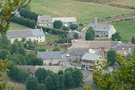 The village of Veyrès, from above | |
 Saint-Laurent-de-Veyrès Location within Occitanie region  Saint-Laurent-de-Veyrès | |
| Coordinates: 44°46′17″N 3°07′46″E / 44.7714°N 3.1294°ECoordinates: 44°46′17″N 3°07′46″E / 44.7714°N 3.1294°E | |
| Country | France |
| Region | Occitanie |
| Department | Lozère |
| Arrondissement | Mende |
| Canton | Aumont-Aubrac |
| Intercommunality | Hautes Terres |
| Government | |
| • Mayor (2008–2014) | Alain Brun |
| Area1 | 9.11 km2 (3.52 sq mi) |
| Population (1999)2 | 37 |
| • Density | 4.1/km2 (11/sq mi) |
| Time zone | UTC+1 (CET) |
| • Summer (DST) | UTC+2 (CEST) |
| INSEE/Postal code | 48167 /48310 |
| Elevation |
1,030–1,271 m (3,379–4,170 ft) (avg. 1,150 m or 3,770 ft) |
|
1 French Land Register data, which excludes lakes, ponds, glaciers > 1 km2 (0.386 sq mi or 247 acres) and river estuaries. 2 Population without double counting: residents of multiple communes (e.g., students and military personnel) only counted once. | |
Saint-Laurent-de-Veyrès is a commune in the Lozère department in southern France.
See also
References
| Wikimedia Commons has media related to Saint-Laurent-de-Veyrès. |
This article is issued from
Wikipedia.
The text is licensed under Creative Commons - Attribution - Sharealike.
Additional terms may apply for the media files.