La Bastide-Puylaurent
| La Bastide-Puylaurent | ||
|---|---|---|
| Commune | ||
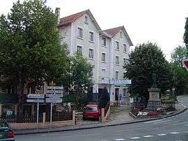 The war memorial outside the Les Pins Hotel, in La Bastide-Puylaurent | ||
| ||
 La Bastide-Puylaurent Location within Occitanie region  La Bastide-Puylaurent | ||
| Coordinates: 44°35′36″N 3°54′22″E / 44.5933°N 3.9061°ECoordinates: 44°35′36″N 3°54′22″E / 44.5933°N 3.9061°E | ||
| Country | France | |
| Region | Occitanie | |
| Department | Lozère | |
| Arrondissement | Mende | |
| Canton | Saint-Étienne-du-Valdonnez | |
| Government | ||
| • Mayor (2008–2014) | Michel Teissier | |
| Area1 | 24.19 km2 (9.34 sq mi) | |
| Population (2009)2 | 169 | |
| • Density | 7.0/km2 (18/sq mi) | |
| Time zone | UTC+1 (CET) | |
| • Summer (DST) | UTC+2 (CEST) | |
| INSEE/Postal code | 48021 /48250 | |
| Elevation |
751–1,328 m (2,464–4,357 ft) (avg. 1,024 m or 3,360 ft) | |
|
1 French Land Register data, which excludes lakes, ponds, glaciers > 1 km2 (0.386 sq mi or 247 acres) and river estuaries. 2 Population without double counting: residents of multiple communes (e.g., students and military personnel) only counted once. | ||
.svg.png)
La Bastide-Puylaurent is a commune in the Lozère department in southern France.
The Trappist monastery Notre-Dame-des-Neiges (Our Lady of the Snows), visited by Robert Louis Stevenson in 1878 and described in his book Travels with a Donkey in the Cévennes, is about one and a half miles east of the village, in the Ardèche department. The Robert Louis Stevenson Trail (GR 70), a popular long-distance path approximately following Stevenson's journey, runs through the village.[1]
Geography
The Chassezac forms part of the commune's southwestern border.
The town lies in the northern part of the commune, where it is crossed by the Allier, which flows northeast through the northern part of the commune.
Population
| Historical population | ||
|---|---|---|
| Year | Pop. | ±% |
| 1793 | 210 | — |
| 1800 | 300 | +42.9% |
| 1806 | 190 | −36.7% |
| 1821 | 175 | −7.9% |
| 1831 | 218 | +24.6% |
| 1836 | 262 | +20.2% |
| 1841 | 268 | +2.3% |
| 1846 | 285 | +6.3% |
| 1851 | 271 | −4.9% |
| 1856 | 282 | +4.1% |
| 1861 | 276 | −2.1% |
| 1866 | 252 | −8.7% |
| 1872 | 348 | +38.1% |
| 1876 | 291 | −16.4% |
| 1881 | 351 | +20.6% |
| 1886 | 357 | +1.7% |
| 1891 | 325 | −9.0% |
| 1896 | 313 | −3.7% |
| 1901 | 300 | −4.2% |
| 1906 | 280 | −6.7% |
| 1911 | 260 | −7.1% |
| 1921 | 268 | +3.1% |
| 1926 | 269 | +0.4% |
| 1931 | 249 | −7.4% |
| 1936 | 289 | +16.1% |
| 1946 | 355 | +22.8% |
| 1954 | 212 | −40.3% |
| 1962 | 345 | +62.7% |
| 1968 | 242 | −29.9% |
| 1975 | 191 | −21.1% |
| 1982 | 176 | −7.9% |
| 1990 | 183 | +4.0% |
| 1999 | 157 | −14.2% |
| 2006 | 172 | +9.6% |
| 2009 | 169 | −1.7% |
See also
References
External links
| Wikimedia Commons has media related to La Bastide-Puylaurent. |
- La Bastide-Puylaurent in Lozere (separate texts in French, Dutch and German; photographs)
- Long hiking trails through La Bastide-Puylaurent:
- Little hiking loops around La Bastide-Puylaurent:
- Hamlets of the commune La Bastide-Puylaurent