Saint-Juéry, Lozère
| Saint-Juéry | |
|---|---|
| Commune | |
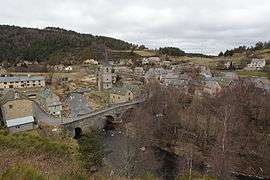 A general view of Saint-Juéry, with the church, and bridge over the river | |
 Saint-Juéry Location within Occitanie region  Saint-Juéry | |
| Coordinates: 44°49′42″N 3°05′12″E / 44.8283°N 3.0867°ECoordinates: 44°49′42″N 3°05′12″E / 44.8283°N 3.0867°E | |
| Country | France |
| Region | Occitanie |
| Department | Lozère |
| Arrondissement | Mende |
| Canton | Aumont-Aubrac |
| Intercommunality | Hautes Terres |
| Government | |
| • Mayor (2008–2014) | Pierre Rozier |
| Area1 | 1.65 km2 (0.64 sq mi) |
| Population (1999)2 | 60 |
| • Density | 36/km2 (94/sq mi) |
| Time zone | UTC+1 (CET) |
| • Summer (DST) | UTC+2 (CEST) |
| INSEE/Postal code | 48161 /48310 |
| Elevation |
910–1,064 m (2,986–3,491 ft) (avg. 920 m or 3,020 ft) |
|
1 French Land Register data, which excludes lakes, ponds, glaciers > 1 km2 (0.386 sq mi or 247 acres) and river estuaries. 2 Population without double counting: residents of multiple communes (e.g., students and military personnel) only counted once. | |
Saint-Juéry is a commune in the Lozère department in southern France.
See also
References
| Wikimedia Commons has media related to Saint-Juéry (Lozère). |
This article is issued from
Wikipedia.
The text is licensed under Creative Commons - Attribution - Sharealike.
Additional terms may apply for the media files.