Saint-Hilaire-de-Lavit
| Saint-Hilaire-de-Lavit | |
|---|---|
| Commune | |
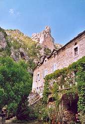 A view within Saint-Hilaire-de-Lavit | |
 Saint-Hilaire-de-Lavit Location within Occitanie region  Saint-Hilaire-de-Lavit | |
| Coordinates: 44°15′15″N 3°51′53″E / 44.2542°N 3.8647°ECoordinates: 44°15′15″N 3°51′53″E / 44.2542°N 3.8647°E | |
| Country | France |
| Region | Occitanie |
| Department | Lozère |
| Arrondissement | Florac |
| Canton | Le Collet-de-Dèze |
| Intercommunality | Vallée Longue et du Calbertois en Cévennes |
| Government | |
| • Mayor (2008–2014) | Christiane Blanc |
| Area1 | 10.51 km2 (4.06 sq mi) |
| Population (1999)2 | 86 |
| • Density | 8.2/km2 (21/sq mi) |
| Time zone | UTC+1 (CET) |
| • Summer (DST) | UTC+2 (CEST) |
| INSEE/Postal code | 48158 /48160 |
| Elevation |
333–927 m (1,093–3,041 ft) (avg. 550 m or 1,800 ft) |
|
1 French Land Register data, which excludes lakes, ponds, glaciers > 1 km2 (0.386 sq mi or 247 acres) and river estuaries. 2 Population without double counting: residents of multiple communes (e.g., students and military personnel) only counted once. | |
Saint-Hilaire-de-Lavit is a commune in the Lozère department in southern France.
See also
References
| Wikimedia Commons has media related to Saint-Hilaire-de-Lavit. |
This article is issued from
Wikipedia.
The text is licensed under Creative Commons - Attribution - Sharealike.
Additional terms may apply for the media files.