Sérignac, Lot
| Sérignac | |
|---|---|
| Commune | |
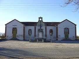 The town hall of Sérignac | |
 Sérignac Location within Occitanie region  Sérignac | |
| Coordinates: 44°26′05″N 1°06′20″E / 44.4347°N 1.1056°ECoordinates: 44°26′05″N 1°06′20″E / 44.4347°N 1.1056°E | |
| Country | France |
| Region | Occitanie |
| Department | Lot |
| Arrondissement | Arrondissement of Cahors |
| Canton | Canton of Puy-l'Évêque |
| Intercommunality | Communauté de communes de la Vallée du Lot et du Vignoble |
| Government | |
| • Mayor (2008–2014) | Joël Mourgues |
| Area1 | 18.44 km2 (7.12 sq mi) |
| Population (1999)2 | 313 |
| • Density | 17/km2 (44/sq mi) |
| Time zone | UTC+1 (CET) |
| • Summer (DST) | UTC+2 (CEST) |
| INSEE/Postal code | 46305 /46700 |
| Elevation |
160–274 m (525–899 ft) (avg. 250 m or 820 ft) |
|
1 French Land Register data, which excludes lakes, ponds, glaciers > 1 km2 (0.386 sq mi or 247 acres) and river estuaries. 2 Population without double counting: residents of multiple communes (e.g., students and military personnel) only counted once. | |
Sérignac is a commune in the Lot department in south-western France.
See also
| Wikimedia Commons has media related to Sérignac (Lot). |
This article is issued from
Wikipedia.
The text is licensed under Creative Commons - Attribution - Sharealike.
Additional terms may apply for the media files.