Cardaillac
| Cardaillac | |
|---|---|
| Commune | |
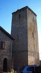 Tour Sagnes | |
 Cardaillac Location within Occitanie region  Cardaillac | |
| Coordinates: 44°40′51″N 1°59′52″E / 44.6808°N 1.9978°ECoordinates: 44°40′51″N 1°59′52″E / 44.6808°N 1.9978°E | |
| Country | France |
| Region | Occitanie |
| Department | Lot |
| Arrondissement | Figeac |
| Canton | Lacapelle-Marival |
| Area1 | 18.1 km2 (7.0 sq mi) |
| Population (1999)2 | 498 |
| • Density | 28/km2 (71/sq mi) |
| Time zone | UTC+1 (CET) |
| • Summer (DST) | UTC+2 (CEST) |
| INSEE/Postal code | 46057 /46100 |
| Elevation |
226–575 m (741–1,886 ft) (avg. 375 m or 1,230 ft) |
|
1 French Land Register data, which excludes lakes, ponds, glaciers > 1 km2 (0.386 sq mi or 247 acres) and river estuaries. 2 Population without double counting: residents of multiple communes (e.g., students and military personnel) only counted once. | |
Cardaillac is a commune in the Lot department in south-western France.
It is located 9 km (5.6 mi) northwest of Figeac.
The village is located on the edge of the Limargue—a rich agricultural region—and Ségala, a poor rye- and chestnut-producing region. It has a rich medieval history and has been officially listed as one of the "most beautiful French villages".
A stronghold was built on a rocky promontory above Cardaillac from 1064 at the orders of Hugo, lord of Cardaillac. Today only three towers remain, dating from the thirteenth century. In 1188 it was attacked by Richard the Lionheart soon before his accession to the throne.
On 11 May 1944 three youths were executed by the "Das Reich" division, which subsequently massacred the population of Oradour-sur-Glane.
Bibliography
- Des blasons pour le Hérisson Laure and Jean-Luc Angélis, Téqui éditions, ISBN 2-7403-0638-5.
See also
External links
| Wikimedia Commons has media related to Cardaillac. |