Albas, Lot
| Albas | |
|---|---|
| Commune | |
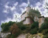 Château de la Blainie | |
 Albas Location within Occitanie region  Albas | |
| Coordinates: 44°28′10″N 1°14′15″E / 44.4694°N 1.2375°ECoordinates: 44°28′10″N 1°14′15″E / 44.4694°N 1.2375°E | |
| Country | France |
| Region | Occitanie |
| Department | Lot |
| Arrondissement | Cahors |
| Canton | Luzech |
| Intercommunality | Vallée Lot Vignoble |
| Government | |
| • Mayor (2014-2020) | Martial Stambouli |
| Area1 | 21.84 km2 (8.43 sq mi) |
| Population (2014)2 | 520 |
| • Density | 24/km2 (62/sq mi) |
| Time zone | UTC+1 (CET) |
| • Summer (DST) | UTC+2 (CEST) |
| INSEE/Postal code | 46001 /46140 |
| Elevation |
85–332 m (279–1,089 ft) (avg. 107 m or 351 ft) |
|
1 French Land Register data, which excludes lakes, ponds, glaciers > 1 km2 (0.386 sq mi or 247 acres) and river estuaries. 2 Population without double counting: residents of multiple communes (e.g., students and military personnel) only counted once. | |
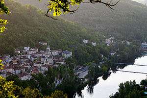
Albas (Albàs in Occitan) is a commune in the Lot department in southwestern France.
Population
Inhabitants of Albas are called Albasois.
| Historical population | ||
|---|---|---|
| Year | Pop. | ±% |
| 1962 | 411 | — |
| 1968 | 504 | +22.6% |
| 1975 | 522 | +3.6% |
| 1982 | 545 | +4.4% |
| 1990 | 507 | −7.0% |
| 1999 | 545 | +7.5% |
| 2006 | 517 | −5.1% |
| 2006 | 511 | −1.2% |
See also
References
| Wikimedia Commons has media related to Albas, Lot. |
| Authority control |
|---|
This article is issued from
Wikipedia.
The text is licensed under Creative Commons - Attribution - Sharealike.
Additional terms may apply for the media files.