Terrou
| Terrou | |
|---|---|
| Commune | |
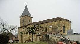 The church of Terrou | |
 Terrou Location within Occitanie region  Terrou | |
| Coordinates: 44°47′05″N 1°59′04″E / 44.7847°N 1.9844°ECoordinates: 44°47′05″N 1°59′04″E / 44.7847°N 1.9844°E | |
| Country | France |
| Region | Occitanie |
| Department | Lot |
| Arrondissement | Figeac |
| Canton | Lacapelle-Marival |
| Intercommunality | Communauté de communes du Haut-Ségala |
| Government | |
| • Mayor (2008–2014) | Jean-Pierre Dufourcq |
| Area1 | 9.94 km2 (3.84 sq mi) |
| Population (1999)2 | 202 |
| • Density | 20/km2 (53/sq mi) |
| Time zone | UTC+1 (CET) |
| • Summer (DST) | UTC+2 (CEST) |
| INSEE/Postal code | 46314 /46120 |
| Elevation |
273–570 m (896–1,870 ft) (avg. 339 m or 1,112 ft) |
|
1 French Land Register data, which excludes lakes, ponds, glaciers > 1 km2 (0.386 sq mi or 247 acres) and river estuaries. 2 Population without double counting: residents of multiple communes (e.g., students and military personnel) only counted once. | |
Terrou is a commune in the Lot department in south-western France.
See also
External links
![]()
This article is issued from
Wikipedia.
The text is licensed under Creative Commons - Attribution - Sharealike.
Additional terms may apply for the media files.