Puybrun
| Puybrun | |
|---|---|
| Commune | |
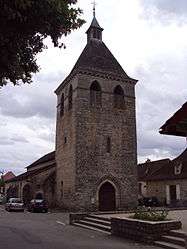 The church of Saint-Blaise | |
 Puybrun Location within Occitanie region  Puybrun | |
| Coordinates: 44°55′10″N 1°47′16″E / 44.9194°N 1.7878°ECoordinates: 44°55′10″N 1°47′16″E / 44.9194°N 1.7878°E | |
| Country | France |
| Region | Occitanie |
| Department | Lot |
| Arrondissement | Figeac |
| Canton | Cère et Ségala |
| Intercommunality | Communauté de communes Cère et Dordogne |
| Government | |
| • Mayor (2001–2008) | Jacques Lorblanchet |
| Area1 | 4.36 km2 (1.68 sq mi) |
| Population (1999)2 | 733 |
| • Density | 170/km2 (440/sq mi) |
| Time zone | UTC+1 (CET) |
| • Summer (DST) | UTC+2 (CEST) |
| INSEE/Postal code | 46229 /46130 |
| Elevation |
125–266 m (410–873 ft) (avg. 155 m or 509 ft) |
|
1 French Land Register data, which excludes lakes, ponds, glaciers > 1 km2 (0.386 sq mi or 247 acres) and river estuaries. 2 Population without double counting: residents of multiple communes (e.g., students and military personnel) only counted once. | |
Puybrun is a commune in the Lot department in south-western France.
See also
| Wikimedia Commons has media related to Puybrun. |
This article is issued from
Wikipedia.
The text is licensed under Creative Commons - Attribution - Sharealike.
Additional terms may apply for the media files.