Gignac, Lot
| Gignac | |
|---|---|
| Commune | |
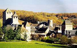 A general view of Gignac | |
 Gignac Location within Occitanie region  Gignac | |
| Coordinates: 45°00′21″N 1°27′30″E / 45.0058°N 1.4583°ECoordinates: 45°00′21″N 1°27′30″E / 45.0058°N 1.4583°E | |
| Country | France |
| Region | Occitanie |
| Department | Lot |
| Arrondissement | Gourdon |
| Canton | Souillac |
| Intercommunality | Communauté de communes du Pays de Martel |
| Government | |
| • Mayor (2008–2014) | Marcel Labroue |
| Area1 | 40.66 km2 (15.70 sq mi) |
| Population (1999)2 | 562 |
| • Density | 14/km2 (36/sq mi) |
| Time zone | UTC+1 (CET) |
| • Summer (DST) | UTC+2 (CEST) |
| INSEE/Postal code | 46118 /46600 |
| Elevation |
153–356 m (502–1,168 ft) (avg. 292 m or 958 ft) |
|
1 French Land Register data, which excludes lakes, ponds, glaciers > 1 km2 (0.386 sq mi or 247 acres) and river estuaries. 2 Population without double counting: residents of multiple communes (e.g., students and military personnel) only counted once. | |
Gignac is a commune in the Lot department in south-western France.
See also
Gallery
| Wikimedia Commons has media related to Gignac (Lot). |
This article is issued from
Wikipedia.
The text is licensed under Creative Commons - Attribution - Sharealike.
Additional terms may apply for the media files.