Montcabrier, Lot
| Montcabrier | ||
|---|---|---|
| Commune | ||
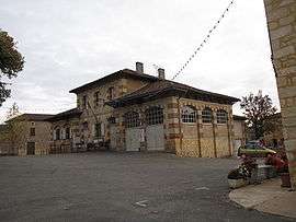 The town hall in Montcabrier | ||
| ||
 Montcabrier Location within Occitanie region  Montcabrier | ||
| Coordinates: 44°32′33″N 1°04′30″E / 44.5425°N 1.075°ECoordinates: 44°32′33″N 1°04′30″E / 44.5425°N 1.075°E | ||
| Country | France | |
| Region | Occitanie | |
| Department | Lot | |
| Arrondissement | Cahors | |
| Canton | Puy-l'Évêque | |
| Intercommunality | Communauté de communes de la Vallée du Lot et du Vignoble | |
| Government | ||
| • Mayor (2008–2014) | Didier Doriac | |
| Area1 | 21.75 km2 (8.40 sq mi) | |
| Population (1999)2 | 385 | |
| • Density | 18/km2 (46/sq mi) | |
| Time zone | UTC+1 (CET) | |
| • Summer (DST) | UTC+2 (CEST) | |
| INSEE/Postal code | 46199 /46700 | |
| Elevation |
103–271 m (338–889 ft) (avg. 191 m or 627 ft) | |
|
1 French Land Register data, which excludes lakes, ponds, glaciers > 1 km2 (0.386 sq mi or 247 acres) and river estuaries. 2 Population without double counting: residents of multiple communes (e.g., students and military personnel) only counted once. | ||

Montcabrier is a commune in the Lot department in south-western France.
See also
| Wikimedia Commons has media related to Montcabrier (Lot). |
This article is issued from
Wikipedia.
The text is licensed under Creative Commons - Attribution - Sharealike.
Additional terms may apply for the media files.