Castelnau-Montratier-Sainte-Alauzie
| Castelnau-Montratier-Sainte-Alauzie | |
|---|---|
| Commune | |
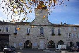 The town hall of Castelnau-Montratier | |
 Castelnau-Montratier-Sainte-Alauzie Location within Occitanie region  Castelnau-Montratier-Sainte-Alauzie | |
| Coordinates: 44°16′12″N 1°21′14″E / 44.270°N 1.354°ECoordinates: 44°16′12″N 1°21′14″E / 44.270°N 1.354°E | |
| Country | France |
| Region | Occitanie |
| Department | Lot |
| Arrondissement | Cahors |
| Canton | Marches du Sud-Quercy |
| Intercommunality | Quercy Blanc |
| Area1 | 84.76 km2 (32.73 sq mi) |
| Population (2014)2 | 1,940 |
| • Density | 23/km2 (59/sq mi) |
| Time zone | UTC+1 (CET) |
| • Summer (DST) | UTC+2 (CEST) |
| INSEE/Postal code | 46063 /46170 |
|
1 French Land Register data, which excludes lakes, ponds, glaciers > 1 km2 (0.386 sq mi or 247 acres) and river estuaries. 2 Population without double counting: residents of multiple communes (e.g., students and military personnel) only counted once. | |
Castelnau-Montratier-Sainte-Alauzie is a commune in the department of Lot, southern France. The municipality was established on 1 January 2017 by merger of the former communes of Castelnau-Montratier (the seat) and Sainte-Alauzie.[1]
See also
References
| Wikimedia Commons has media related to Castelnau-Montratier-Sainte-Alauzie. |
- ↑ Arrêté préfectoral 3 August 2016 (in French)
This article is issued from
Wikipedia.
The text is licensed under Creative Commons - Attribution - Sharealike.
Additional terms may apply for the media files.