Marcilhac-sur-Célé
| Marcilhac-sur-Célé | |
|---|---|
| Commune | |
 A street in Marcilhac-sur-Célé | |
 Marcilhac-sur-Célé Location within Occitanie region  Marcilhac-sur-Célé | |
| Coordinates: 44°33′15″N 1°46′18″E / 44.5542°N 1.7717°ECoordinates: 44°33′15″N 1°46′18″E / 44.5542°N 1.7717°E | |
| Country | France |
| Region | Occitanie |
| Department | Lot |
| Arrondissement | Figeac |
| Canton | Causse et Vallées |
| Intercommunality | Figeac-Communauté |
| Government | |
| • Mayor (2001–2008) | Michel Delpech |
| Area1 | 27.35 km2 (10.56 sq mi) |
| Population (2006)2 | 199 |
| • Density | 7.3/km2 (19/sq mi) |
| Time zone | UTC+1 (CET) |
| • Summer (DST) | UTC+2 (CEST) |
| INSEE/Postal code | 46183 /46160 |
| Elevation | 140–391 m (459–1,283 ft) |
|
1 French Land Register data, which excludes lakes, ponds, glaciers > 1 km2 (0.386 sq mi or 247 acres) and river estuaries. 2 Population without double counting: residents of multiple communes (e.g., students and military personnel) only counted once. | |
Marcilhac-sur-Célé is a commune in the Lot department in south-western France. It has many historic buildings, including the ruined 9th century Abbey of St Peter.
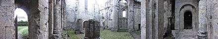
Panorama of the ruined abbey.
See also
| Wikimedia Commons has media related to Marcilhac-sur-Célé. |
This article is issued from
Wikipedia.
The text is licensed under Creative Commons - Attribution - Sharealike.
Additional terms may apply for the media files.