Ginouillac
| Ginouillac | |
|---|---|
| Commune | |
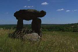 The Dolmen des Cloups, in Ginouillac | |
 Ginouillac Location within Occitanie region  Ginouillac | |
| Coordinates: 44°43′36″N 1°32′21″E / 44.7267°N 1.5392°ECoordinates: 44°43′36″N 1°32′21″E / 44.7267°N 1.5392°E | |
| Country | France |
| Region | Occitanie |
| Department | Lot |
| Arrondissement | Gourdon |
| Canton | Causse et Bouriane |
| Intercommunality | Communauté de communes du Causse de Labastide-Murat |
| Government | |
| • Mayor (2008–2014) | Claude Bonnassie |
| Area1 | 9.42 km2 (3.64 sq mi) |
| Population (1999)2 | 165 |
| • Density | 18/km2 (45/sq mi) |
| Time zone | UTC+1 (CET) |
| • Summer (DST) | UTC+2 (CEST) |
| INSEE/Postal code | 46121 /46300 |
| Elevation |
215–446 m (705–1,463 ft) (avg. 350 m or 1,150 ft) |
|
1 French Land Register data, which excludes lakes, ponds, glaciers > 1 km2 (0.386 sq mi or 247 acres) and river estuaries. 2 Population without double counting: residents of multiple communes (e.g., students and military personnel) only counted once. | |
Ginouillac is a commune in the Lot department in southwestern France.
See also
| Wikimedia Commons has media related to Ginouillac. |
This article is issued from
Wikipedia.
The text is licensed under Creative Commons - Attribution - Sharealike.
Additional terms may apply for the media files.