Les Junies
| Les Junies | |
|---|---|
| Commune | |
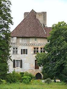 The chateau in Les Junies | |
 Les Junies Location within Occitanie region  Les Junies | |
| Coordinates: 44°32′21″N 1°14′10″E / 44.5392°N 1.2361°ECoordinates: 44°32′21″N 1°14′10″E / 44.5392°N 1.2361°E | |
| Country | France |
| Region | Occitanie |
| Department | Lot |
| Arrondissement | Arrondissement of Cahors |
| Canton | Puy-l'Évêque |
| Intercommunality | Communauté de communes de Catus |
| Government | |
| • Mayor (2008–2014) | Jean-Pierre Bergon |
| Area1 | 13.06 km2 (5.04 sq mi) |
| Population (1999)2 | 264 |
| • Density | 20/km2 (52/sq mi) |
| Time zone | UTC+1 (CET) |
| • Summer (DST) | UTC+2 (CEST) |
| INSEE/Postal code | 46134 /46150 |
| Elevation |
100–296 m (328–971 ft) (avg. 117 m or 384 ft) |
|
1 French Land Register data, which excludes lakes, ponds, glaciers > 1 km2 (0.386 sq mi or 247 acres) and river estuaries. 2 Population without double counting: residents of multiple communes (e.g., students and military personnel) only counted once. | |
Les Junies is a commune in the Lot department in south-western France.
See also
| Wikimedia Commons has media related to Les Junies. |
This article is issued from
Wikipedia.
The text is licensed under Creative Commons - Attribution - Sharealike.
Additional terms may apply for the media files.