Espagnac-Sainte-Eulalie
| Espagnac-Sainte-Eulalie | |
|---|---|
| Commune | |
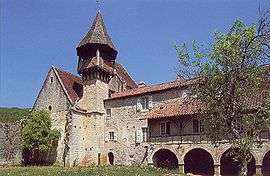 The abbey in Espagnac-Sainte-Eulalie | |
 Espagnac-Sainte-Eulalie Location within Occitanie region  Espagnac-Sainte-Eulalie | |
| Coordinates: 44°35′36″N 1°50′28″E / 44.5933°N 1.8411°ECoordinates: 44°35′36″N 1°50′28″E / 44.5933°N 1.8411°E | |
| Country | France |
| Region | Occitanie |
| Department | Lot |
| Arrondissement | Figeac |
| Canton | Causse et Vallées |
| Intercommunality | Communauté de communes de la Vallée et du Causse |
| Government | |
| • Mayor (2001–2008) | Martine Benet Bagreaux |
| Area1 | 9.75 km2 (3.76 sq mi) |
| Population (2006)2 | 82 |
| • Density | 8.4/km2 (22/sq mi) |
| Demonym(s) | Espagnaquois |
| Time zone | UTC+1 (CET) |
| • Summer (DST) | UTC+2 (CEST) |
| INSEE/Postal code | 46093 /46320 |
| Elevation | 161–426 m (528–1,398 ft) |
|
1 French Land Register data, which excludes lakes, ponds, glaciers > 1 km2 (0.386 sq mi or 247 acres) and river estuaries. 2 Population without double counting: residents of multiple communes (e.g., students and military personnel) only counted once. | |
Espagnac-Sainte-Eulalie is a commune in the Lot department in south-western France.
See also
| Wikimedia Commons has media related to Espagnac-Sainte-Eulalie. |
This article is issued from
Wikipedia.
The text is licensed under Creative Commons - Attribution - Sharealike.
Additional terms may apply for the media files.