Limogne-en-Quercy
| Limogne-en-Quercy | |
|---|---|
| Commune | |
.jpg) The Dolmen of the Aurie Lake known as "Pech Lapeyre" in Limogne-en-Quercy | |
 Limogne-en-Quercy Location within Occitanie region  Limogne-en-Quercy | |
| Coordinates: 44°23′54″N 1°46′16″E / 44.3983°N 1.7711°ECoordinates: 44°23′54″N 1°46′16″E / 44.3983°N 1.7711°E | |
| Country | France |
| Region | Occitanie |
| Department | Lot |
| Arrondissement | Cahors |
| Canton | Marches du Sud-Quercy |
| Government | |
| • Mayor (2008–2014) | Joël Massabie |
| Area1 | 32.31 km2 (12.47 sq mi) |
| Population (2006)2 | 788 |
| • Density | 24/km2 (63/sq mi) |
| Time zone | UTC+1 (CET) |
| • Summer (DST) | UTC+2 (CEST) |
| INSEE/Postal code | 46173 /46260 |
| Elevation | 214–403 m (702–1,322 ft) |
|
1 French Land Register data, which excludes lakes, ponds, glaciers > 1 km2 (0.386 sq mi or 247 acres) and river estuaries. 2 Population without double counting: residents of multiple communes (e.g., students and military personnel) only counted once. | |
Limogne-en-Quercy is a commune in the Lot department in south-western France.
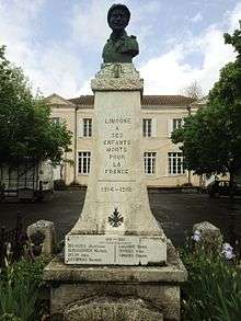
Monument to those from the commune who died in World War I and World War II
See also
| Wikimedia Commons has media related to Limogne-en-Quercy. |
This article is issued from
Wikipedia.
The text is licensed under Creative Commons - Attribution - Sharealike.
Additional terms may apply for the media files.