Conanicut Island
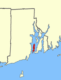

Conanicut Island is the second largest island in Narragansett Bay in the US state of Rhode Island. It is connected on the east by the Claiborne Pell Bridge[1] to Newport on Aquidneck Island, and on the west by the Jamestown-Verrazano Bridge to North Kingstown on the mainland. The island comprises the town of Jamestown, Rhode Island. The United States Census Bureau reported a land area of 24.46 km2 (9.44 sq mi) and a population of 5,622 as of the 2000 census.
History
Conanicut Island was home to many American Indians, at least on a seasonal basis. The largest Indian cemetery in New England is located on the island, and artifacts have been recovered from a site near the elementary school. The island is named for Chief Canonicus of the Narragansett tribe who once inhabited the land and maintained his royal residence on the island.[2]
In 1636 or 1637, Dutch fur traders paid to use the island of Quentenis as a base for their activities. This island is located just west of Conanicut; it is now known as Dutch Island and is part of Jamestown.
In 1638, the English colonists made arrangements to use Conanicut Island for grazing sheep, and Canonicus was one of the Narragansett sachems who gave consent. As a result, the name "Conanicut" was given to the island and the figure of a sheep is in a central position in the Jamestown seal.
Conanicut Island was a part of the island territory included in a patent given to William Coddington by the English in 1651.[3]
In 1657, a consortium of about one hundred buyers purchased Conanicut, Dutch, and Gould Islands. They divided Conanicut Island into roughly one dozen large plots and reserved Dutch Island and parts of Conanicut Island for common use. Benedict Arnold was one of the purchasers, and he became governor of the colony of Rhode Island the same year. (Arnold was the great-grandfather of the Revolutionary War traitor.)
The Indians and colonists lived side-by-side in relative peace for almost four decades. Conflicts eventually occurred in a number of places in southern New England, leading to what is known as King Philip's War. Life in the region was dominated by the colonists after 1676, although Conanicut Island remained a haven for many Indians.
In 1725, a ferry was established between the island and Newport. Another ferry was established to South Kingstown in 1748.[3]
References
- ↑ The Claiborne Pell Bridge is commonly known as the Newport Bridge.
- ↑ Rhode Island Geography
- 1 2 Bicknell, Thomas Williams. The History of the State of Rhode Island and Providence Plantations. New York: The American Historical Society, Inc. (1920). Vol. 3, p. 1184.
| Islands |  | |
|---|---|---|
| Major rivers | ||
| Cities & towns | ||
| Bridges | ||