Sakonnet River Bridge
| Sakonnet River Bridge | |
|---|---|
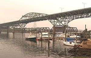 Sakonnet River Bridge (Truss), 1956-2012, Slated for Demolition 2018 | |
| Coordinates | 41°38′17″N 71°12′50″W / 41.6381°N 71.2140°WCoordinates: 41°38′17″N 71°12′50″W / 41.6381°N 71.2140°W |
| Carries |
|
| Crosses | Sakonnet River |
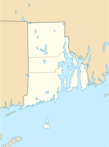
| Locale | between Portsmouth and Tiverton |
| Characteristics | |
| Design |
truss bridge (1st) Box girder bridge (2nd) |
| History | |
| Opened | 1956 (1st bridge), 2012 (2nd bridge) |
| Closed | 2012 (1st bridge) |
 | |
The Sakonnet River Bridge is a four-lane bridge spanning the Sakonnet River in eastern Rhode Island. The bridge carries RI 24 and RI 138 between the communities of Portsmouth and Tiverton, Rhode Island. The truss bridge was built in 1956 but closed and replaced in September 2012 with a box girder bridge. The replacement of the Sakonnet Bridge ended a several years long ban of heavy commercial vehicles weighing over 18 tons.
The Sakonnet River Bridge (truss) opened in 1956 as a replacement for the Stone Bridge, about 0.8 mi (1.3 km) to the south. It became part of RI 24 during the 1960s after the completion of the Portsmouth and Tiverton Expressways. At one point, it was briefly considered for inclusion as part of the never-built Interstate 895. Upon completion of the new Sakonnet River Bridge (box girder bridge) in September 2012, the old truss bridge was closed.
Bicycles were not permitted on the old bridge, but will soon be allowed on the new bridge.[1]
Toll collection on this bridge started on August 19, 2013. After a lengthy legal battle, the toll was set at 10 cents per crossing. Toll collection was electronic only. Since there was no official plan on how tolls were to be collected from Non-EZPass users, the state had asked those travelers to pay using the honor system.[2]
The collection of tolls ended on June 20, 2014.[3]
Replacement
By the late 1990s, the Sakonnet River Bridge's design had become obsolete, and transportation planners began to develop a plan for the bridge's future. Significant deterioration of the bridge necessitated a ban of vehicles weighing over 18 tons, re-routing traffic over the narrower and less commercial truck-friendly RI 136/114 and the Mount Hope Bridge.[4] In 2003, the Rhode Island Department of Transportation (RIDOT) announced plans for a $120 million (USD) replacement bridge to be built just south of the existing bridge. Groundbreaking for the new bridge took place in April 2009, and the bridge opened behind schedule in October 2012.[5][6]
Demolition
RIDOT began the process of demolishing the old truss bridge in March 2017. This first phase will remove the 17 spans of bridge deck covering 2,178 feet between the bridge's piers.[7] The center span of the bridge was removed on April 12, 2018. After cutting it free from the bridge, it was slowly lowered onto barges in the water below. The demolition had been delayed due to bad weather and safety issues. Most of the bridge is expected to be taken down by Memorial Day.[8]
References
- ↑ "Future Sakonnet River Bridge Bike Path". Rhode Island Department of Transportation. Archived from the original on 2013-07-30. Retrieved 2013-09-05.
- ↑ "Sakonnet River Bridge Tolls". Rhode Island Turnpike and Bridge Authority. Archived from the original on September 12, 2013. Retrieved July 20, 2014.
- ↑ "Tolling on Sakonnet River Bridge Ends on Friday" (PDF). Rhode Island Turnpike and Bridge Authority. Retrieved 2014-06-20.
- ↑ "RIDOT to Lower Posting on Sakonnet River Bridge: Weight Limit to be Set at 18 Tons". RIDOT Press Release. Retrieved 2013-09-05.
- ↑ "Sakonnet River Bridge" (PDF). Haley & Aldrich, Inc. Retrieved 2008-07-08.
- ↑ "Sakonnet River Bridge Replacement Project". RIDOT. Retrieved 2013-11-14.
- ↑ "RIDOT Beginning Demolition of the Old Sakonnet River Bridge". RI.gov. Retrieved 2017-03-02.
- ↑ "Old Sakonnet Bridge demolition". abc6.com. WLNE-TV/ABC6. Retrieved 2018-04-14.
External links
- Web site containing engineering impact documents for the replacement of the Sakonnet River Bridge.
| Islands |  | |
|---|---|---|
| Major rivers | ||
| Cities & towns | ||
| Bridges | ||