Smithtown, New York
| Smithtown, New York | ||
|---|---|---|
| Town | ||
| Town of Smithtown | ||
| ||
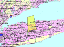 U.S. Census Bureau Map | ||
| Coordinates: 40°51′46″N 73°12′55″W / 40.86278°N 73.21528°WCoordinates: 40°51′46″N 73°12′55″W / 40.86278°N 73.21528°W | ||
| Country | United States | |
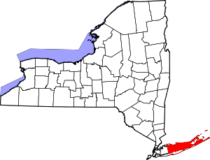
| State | New York | |
| County | Suffolk | |
| Government | ||
| • Town Supervisor | Edward Wehrheim (R) | |
| • Town Council |
Thomas McCarthy (R) Lynne Nowick (R) Lisa Inzerillo (R) Thomas Lohmann (R) | |
| Area[1] | ||
| • Total | 111.45 sq mi (288.64 km2) | |
| • Land | 53.71 sq mi (139.10 km2) | |
| • Water | 57.74 sq mi (149.55 km2) | |
| Elevation | 105 ft (32 m) | |
| Population (2010)[2] | ||
| • Total | 117,801 | |
| • Estimate (2016)[3] | 117,481 | |
| • Density | 2,187.48/sq mi (844.60/km2) | |
| Time zone | UTC−5 (EST) | |
| • Summer (DST) | UTC−4 (EDT) | |
| ZIP codes | 11725, 11745,11754, 11780, 11787, 11788, 11768 (part), 11755 (part), 11779 (part) | |
| Area code(s) | 631 | |
| FIPS code | 36-68000 | |
| Cook PVI | R+24 | |
| Website |
www | |
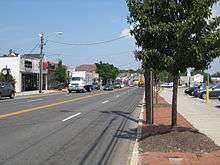
Smithtown is a town in Suffolk County, New York, United States, on the North Shore of Long Island. This town is an eastern suburb of New York City. The population was 117,801 at the 2010 Census.
The census-designated place (CDP) of Smithtown lies within the town's borders.
History
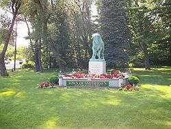
Smithtown originally, known as "Smithfield", was first settled around 1665. Local legend has it that, after rescuing a Native American chief's abducted daughter, Richard Smith was told that the chief would grant title to all of the land Smith could encircle in one day "on a bull". Smith chose to ride the bull on the longest day of the year (summer solstice), to enable him to ride longer "in one day". The land he acquired in this way is said to approximate the current town's location. There is a large anatomically correct[4] statue of Smith's bull, known as Whisper, at the fork of Jericho Turnpike (New York State Route 25) and St. Johnland Road (New York State Route 25A).[5]
The border between Smithtown and the town of Huntington is partially defined by Bread and Cheese Hollow Road (Suffolk County Road 4), so named after Bread and Cheese hollow, which according to legend is where Smith stopped on his ride to have a lunch of bread and cheese. The road is reputed to follow part of his original ride. The border between Smithtown and Huntington was also the site of Fort Salonga, a British fort that was the site of a battle of the American Revolution during 1781.[6][7]
Geography
The Town of Smithtown is located at 40° 52' 13" North, 73° 13' 3" West (40.862786, -73.215175).[8]
According to the United States Census Bureau, the town has a total area of 111.4 square miles (288.5 km²), of which, 53.6 square miles (138.8 km²) of it is land and 57.8 square miles (149.7 km²) of it (51.89%) is water.
Demographics
| Historical population | |||
|---|---|---|---|
| Census | Pop. | %± | |
| 1790 | 1,022 | — | |
| 1800 | 1,413 | 38.3% | |
| 1810 | 1,592 | 12.7% | |
| 1820 | 1,874 | 17.7% | |
| 1830 | 1,686 | −10.0% | |
| 1840 | 1,932 | 14.6% | |
| 1850 | 1,972 | 2.1% | |
| 1860 | 2,130 | 8.0% | |
| 1870 | 2,136 | 0.3% | |
| 1880 | 2,249 | 5.3% | |
| 1890 | 3,357 | 49.3% | |
| 1900 | 5,863 | 74.6% | |
| 1910 | 7,073 | 20.6% | |
| 1920 | 9,114 | 28.9% | |
| 1930 | 11,855 | 30.1% | |
| 1940 | 13,970 | 17.8% | |
| 1950 | 20,993 | 50.3% | |
| 1960 | 50,347 | 139.8% | |
| 1970 | 114,657 | 127.7% | |
| 1980 | 116,663 | 1.7% | |
| 1990 | 113,406 | −2.8% | |
| 2000 | 115,715 | 2.0% | |
| 2010 | 117,801 | 1.8% | |
| Est. 2016 | 117,481 | [3] | −0.3% |
| U.S. Decennial Census[9] | |||
As of the census[10] of 2000, there were 115,715 people, 38,487 households, and 31,482 families residing in the town. The population density was 2,159.9 people per square mile (833.9/km²). There were 39,357 housing units at an average density of 734.6 per square mile (283.6/km²). The racial makeup of the town was:
- 114,817 or 99.2% mono-racial
- 110,546 or 95.5% White
- 748 or 0.65% Black or African American,
- 78 or 0.01% Native American
- 1763 or 1.7% Asian
- 22 or less than 0.01% Pacific Islander
- 660 or 0.6% from other races
- 898 or 0.08% from two or more races.
- 3855 or 3.3% Hispanic or Latino
There were 38,487 households out of which 38.5% had children under the age of 18 living with them, 71.6% were married couples living together, 7.5% had a female householder with no husband present, and 18.2% were non-families. 15.2% of all households were made up of individuals and 7.2% had someone living alone who was 65 years of age or older. The average household size was 2.95 and the average family size was 3.28.
In the town, the population was spread out with 26.0% under the age of 18, 5.4% from 18 to 24, 30.4% from 25 to 44, 24.8% from 45 to 64, and 13.4% who were 65 years of age or older. The median age was 38 years. For every 100 females, there were 94.6 males. For every 1000 females age 18 and over, there were 911.2 males.
According to a 2007 estimate, the median income for a household in the town was $100,165, and the median income for a family was $110,776.[11]
Males had a median income of $61,348 versus $38,208 for females. The per capita income for the town was $31,401. About 2.1% of families and 3.0% of the population were below the poverty line, including 2.9% of those under age 18 and 4.7% of those age 65 or over.
Ancestries: Italian (35.3%), Irish (26.0%), German (18.7%), Polish (6.9%), English (5.0%), Russian (4.1%).[12]
Government and politics
| Councilwoman | Councilman | Supervisor | Councilwoman | Coucilman |
|---|---|---|---|---|
| Lynne Nowick (R)
since January 1, 2014 |
Thomas J. McCarthy (R)
since January 1, 1998 |
Edward Wehrheim (R)
since January 1, 2018 |
Lisa Inzerillo (R)
since January 1, 2015 |
Thomas W. Lohmann (R)
since January 10, 2018 |
The present town hall and seat of the town was built in 1912 on Main Street in Smithtown. In 2015 the town hall was dedicated and renamed after current Supervisor Patrick R. Vecchio.[13]
Smithtown is led by a Town Supervisor and a four-member Town Council, elected town-wide with each serving four year terms. Elections are held on odd numbered years with two of the councilmembers being up for re-election each year.
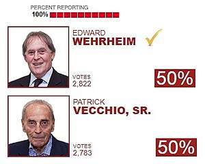
The current Supervisor is Patrick R. Vecchio, who has been Town Supervisor since 1978. Elected as a Democrat during a special election, Vecchio switched parties in 1993 in an attempt to run for County Executive. Although defeated in the primary by Robert Gaffney, Vecchio has remained a Republican to present day. At this time he is currently the longest serving town supervisor in all of New York State. Vecchio ran in 2013 against former Councilman Robert Creighton, of the Conservative Party. Supervisor Vecchio won the Republican Primary against Councilman Creighton and then later defeated the Councilman in the General Election 45-30 (A Democratic candidate, Steven Snair ran as the third party candidate, obtaining 25% of the vote). Councilman Creighton was later ousted in 2015 by Lisa Inzerillo. In the 2017 Republican primary, Councilman Ed Wehrheim received about forty votes more than Vecchio. The race was too close to call and a recount was demanded by Vecchio. Following the recount a week later, Wehrheim was declared the winner, nearly doubling his lead. Vecchio conceded the race the same day saying "“All good things come to an end."[14] On November 7, 2017, Ed Wehrheim defeated William Holst in the election for the town's next supervisor. Wehrheim will succeed Vecchio on January 1, 2018.
The Town of Smithtown has always been dominated by Republicans at all levels of government. This one-party domination has often led to infighting between factions of the Republican Party in Smithtown with the most recent between Supervisor Vecchio and Smithtown Republican Party Chairman William Ellis. The Republican party has never received less than 56% of the vote from the Town of Smithtown. The most Republican areas for Smithtown are its three incorporated villages, Nissequogue, Head of the Harbor, and the Branch, along with the hamlets of Smithtown and Kings Park. The weakest areas for the Republican party in Smithtown is the edges of the Town in the hamlets of Commack and Hauppauge. In 2016 President-elect Donald Trump defeated Hillary Clinton by 28 points, the highest performing town for him on all of Long Island.
In addition to presidential politics, the Town of Smithtown is also the power bases of many State and County elected officials. New York State Senate Majority Leader John J. Flanagan has the bulk of his district located in Smithtown. Current Republican Comptroller John M. Kennedy, Jr., along with his wife, Suffolk County Legislator Leslie Kennedy both reside in Nesconset.
| Year | Republican | Democratic |
|---|---|---|
| 2016 | 63% 35,931 | 36% 20,552 |
| 2012 | 60.17% 32,549 | 39.83% 21,544 |
| 2008 | 56.85% 34,409 | 43.15% 26,114 |
| 2004 | 56.41% 33,686 | 43.59% 26,034 |
| Year | Candidate | Vote | % | |
|---|---|---|---|---|
| 2017 | (R) | Edward Wehrheim |
16,268 | 56.8 |
| (D) | William Holst | 10,047 | 35.0 | |
| (I) | Kristen Slevin | 2,250 | 8.2 | |
| 2013 | (R) | Patrick Vecchio |
9,507 | 45.08 |
| (C) | Robert Creighton | 6,366 | 30.18 | |
| (D) | Steve Snair | 5,218 | 24.74 | |
| 2009 | (R) | Patrick Vecchio |
11,049 | 60.35 |
| (D) | Patricia Biancaniello | 7,051 | 38.51 | |
| (WF) | Deanna DeLieto | 208 | 1.14 | |
| 2005 | (R) | Patrick Vecchio |
12,370 | 55.52 |
| (D) | William Holst | 5,981 | 26.84 | |
| (I) | Jane Conway | 3,929 | 17.63 | |
Communities and locations
Villages (incorporated)
Hamlets (unincorporated)
- Commack (in part, with the Town of Huntington)
- Fort Salonga (in part, with the Town of Huntington)
- Hauppauge (in part, with the Town of Islip)
- Kings Park
- Lake Ronkonkoma (in part with the Town of Brookhaven and Town of Islip)
- Nesconset
- Smithtown
- St. James
Other communities
- North Smithtown
- San Remo
State parks
- Caleb Smith State Park Preserve, a state park southwest of Smithtown village
- Sunken Meadow State Park
- Nissequogue River State Park
- Blydenburgh Park Historic District
Notable people
- Mose Allison, American jazz and blues pianist, singer and song writer
- Cooper Andrews, actors
- Craig Biggio, former Major League baseball player
- Frank Catalanotto, former Major League baseball player
- Dan Corbett, weather broadcaster for the BBC
- Bob Costas, American sportscaster
- John Curtis, American baseball player
- John Daly, Olympic athlete
- Ken DiMaio, Live Sound Engineer and Broadway Lighting Designer
- Rhonda Findling, noted author, psychotherapist
- David DiVona, musician and television personality
- Michael J. Epstein, filmmaker, musician, artist, and writer
- Ilana Glazer, actress and comedian (Broad City)
- Andrew Gross, noted author
- John Hampson - Nine Days lead vocalist
- Emily Hart, American actress (younger sister of Melissa Joan Hart)
- Melissa Joan Hart - American actress (elder sister of Emily Hart)
- Jodi Hauptman, Senior Curator at The Museum of Modern Art, New York; organizer of landmark exhibitions Henri Matisse: The Cut-Outs and Georges Seurat - The Drawings
- Andrew Hauptman, businessman and owner of the Chicago Fire Soccer Club
- Eddie Hayes, celebrated attorney, bon vivant, and memoirist
- Chris Higgins, National Hockey League player
- Keith Law, sportswriter and blogger
- Fredric Lebow, screenwriter
- Curtis Lepore, Internet personality
- Andrew Levy, publicist and co-host of Fox News' Red Eye
- Lori Loughlin, actress
- Jim Mecir, Major League baseball player
- John Miceli, drummer for Meat Loaf
- Michael P. Murphy, Medal of Honor recipient, KIA in operation Red Wing
- Soledad O'Brien, CNN News anchor
- John Petrucci, Dream Theater guitarist
- Jodi Picoult, novelist
- Stephen Rannazzisi, American actor
- Jai Rodriguez, Queer Eye and Broadway actor
- Kevin Thoms, American actor
- Jeremy Wall, founding pianist of the jazz fusion band Spyro Gyra
- William Weld, 68th Governor of Massachusetts (1991–1997)
- Matt Yallof, SNY sports broadcaster
- Adam Conover, American Comedian, Actor, and Writer
Media
Smithtown is the city of license for two radio stations, WFRS Family Radio and WWSK "94.3 the Shark", repeater W228BI for WNYC, and the TV station WFTY-TV. Smithtown broadcasts its board meetings on SGTV, the Town of Smithtown Public service television station; Cablevision channel 18 or Verizon channel 27. Smithtown has three local newspapers, Smithtown Messenger, The Times of Smithtown, and The Smithtown News, which carry community-based articles. Websites such as SmithtownRadio.com serve as hyper-local news outlets for the community.
Emergency services
Fire Protection and Emergency Medical Services are provided by the seven Volunteer Fire Departments, and two Volunteer Ambulance Corps that cover parts of the Township. The Smithtown, Kings Park, Saint James, Nesconset, and Nissequogue Fire Departments provide both Fire Protection, as well as Emergency Medical Services to their districts. The Commack Fire Department and Commack Volunteer Ambulance Corps provide coverage for the Commack hamlet, which is divided between the Town of Smithtown, and the Town of Huntington. The Hauppauge Volunteer Fire Department and Central Islip-Hauppauge Volunteer Ambulance Corps provide coverage to the Hauppauge hamlet, which is divided between the Town of Smithtown, and the Town of Islip.
Smithtown is policed by the 4th Precinct of the Suffolk County Police Department. The Suffolk County Police are the primary law enforcement agency in Smithtown. They are responsible for responding to all 911 emergency calls. The Smithtown Department of Public Safety is an agency with limited powers. The Park Ranger Division is made up peace officers as defined in the Criminal Procedural Law of the state of New York.[16] Their enforcement powers are limited to Smithtown town property. The Department of Public Safety also has a Harbor Master division and Fire Marshall division.
Emergency medical care can be found at St. Catherine of Siena Medical Center, located in Smithtown, as well as the nearby Stony Brook University Hospital, located in Stony Brook, in the neighboring Town of Brookhaven.
Transportation
Railroad lines
The Town of Smithtown is also home to the Kings Park, Smithtown, and Saint James Stations of the Long Island Rail Road's Port Jefferson Branch.
Bus service
The Town of Smithtown is served entirely by Suffolk County Transit bus routes.
Major roads


Education
Smithtown Central School District is home of eight elementary schools, three middle schools, and two high schools.
The Town of Smithtown is also home to the Kings Park Central School District, a portion of the Commack Union-Free School District (shared with the Town of Huntington), a portion of the Hauppauge School District (shared with the Town of Islip) and a portion of the Sachem Central School District (shared with the Town of Brookhaven).
Elementary schools
- Accompsett Elementary School
- Branch Brook Elementary School
- Dogwood Elementary School
- Mills Pond Elementary School
- Mt. Pleasant Elementary School
- Smithtown Elementary School
- St. James Elementary School
- Tackan Elementary School
Middle schools
- Accompsett Middle School (formerly Smithtown High School Freshman Campus 1992-2005)
- Great Hollow Middle School
- Nessaquake Middle school
Smithtown High School
- Eastern Campus (formerly Smithtown Central High School, 1960s-1973; formerly Smithtown High School East, 1973–1992; formerly Smithtown Middle School, 1992–2005) - located in St. James
- The High School's Eastern Campus is composed of graduates of Nesaquake Middle School and those graduates of Great Hollow Middle School that reside in the Tackan and Nesconset Elementary area.
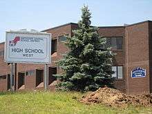
- Western Campus (formerly Smithtown High School West, 1973–1992; formerly Smithtown High School 10-12 Building, 1992–2005)- located in south of the Kings Park Hamlet and west of the Smithtown Bull
- The High School's Western Campus is composed of graduates of Accompsett Middle School and those graduates of Great Hollow Middle School that reside in the Mt. Pleasant and Branch Brook Elementary area.
Private schools
- Smithtown Christian School (pre-school to twelfth grade)
- Saint Patrick School (parochial school grades preschool through eighth)
- Holy Family Regional School (pre-school to eighth grade)
- Saints Philip and James School (parochial school grades preschool through eighth)
- The Knox School(boarding students 7th to PG, day students 6th to PG)
- Ivy League School And Summer Camp (pre-school to eighth)
Former schools (No longer used as K-12 Facilities)
- New York Avenue Junior High School- (now the Joseph M. Barton/New York Avenue Building) Currently the central office and headquarters of Smithown Central School District
- Smithtown Branch High School- Smithtown High School before the opening of Smithtown Central High School in the 1960s
See also
References
- ↑ "2016 U.S. Gazetteer Files". United States Census Bureau. Retrieved Jul 5, 2017.
- ↑ Metropolitan & Central City Population: 2000-2005. Demographia.com, accessed September 3, 2006.
- 1 2 "Population and Housing Unit Estimates". Retrieved June 9, 2017.
- ↑ "The Bull, Smithtown Long, Island". Maggie Land Blanck.
- ↑ Rediscovering Smithtown’s Golden Age of Progressive Architecture; 1911–1948 (Preservation Long Island)
- ↑ http://northporthistorical.org/documents/Brief_History.pdf
- ↑ "Archived copy". Archived from the original on 2009-04-24. Retrieved 2010-11-12.
- ↑ "US Gazetteer files: 2010, 2000, and 1990". United States Census Bureau. 2011-02-12. Retrieved 2011-04-23.
- ↑ "Census of Population and Housing". Census.gov. Retrieved June 4, 2015.
- ↑ "American FactFinder". United States Census Bureau. Retrieved 2008-01-31.
- ↑ " Income in the Past 12 Months (In 2007 Inflation-Adjusted Dollars): 2007 American Community Survey 1-Year Estimates". American Fact Finger. United States Census Bureau. Retrieved April 21, 2017.
- ↑ "Profile of Selected Social Characteristics: 2000. Census 2000 Summary File 3 (SF 3) - Sample Data". American FactFinder. U. S. Census Bureau. 2000. Retrieved 25 January 2018.
- ↑ Hampton, Deon J. (November 1, 2015). "Smithtown Town Hall renamed to honor supervisor Patrick Vecchio". Newsday.
- ↑ Walsh, Sara-Megan (2017-09-28). "Ed Wehrheim dethrones Pat Vecchio, wins Smithtown Supervisor primary - TBR News Media". TBR News Media. Retrieved 2017-10-01.
- ↑ http://uselectionatlas.org/RESULTS/
- ↑ NYS CPL Article 2 Section 2.10(9)
External links
| Wikimedia Commons has media related to Town of Smithtown, New York. |
| Wikivoyage has a travel guide for Smithtown. |
- Smithtown Central School District Website
- Town of Smithtown, NY
- Smithtown history
- Bullrider Smith's Bull "Whisper" Courtesy Maggiblanck.com
- Kings Park Heritage Museum
- Kings Park Chamber of Commerce
- Smithtown Government Television