Greater Torrington
| Greater Torrington | |
|---|---|
| Torrington | |
 | |
| Coordinates: 51°00′N 4°06′W / 51°N 4.1°W | |
| Country | United States |
| State(s) | Connecticut |
| Largest city | Torrington |
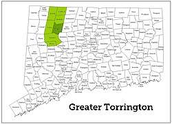
The Greater Torrington Area, as defined by the United States Census Bureau NECTA, is an area in Litchfield County, Connecticut, anchored by the city of Torrington.
New England City and Town Area
The U.S. Census Bureau defines the micropolitan statistical area of Torrington as the Torrington NECTA. This area encompasses the city of Torrington, and the towns of Colebrook and Winchester.[1]
Northwest Hills Region
The Torrington NECTA is located within the area administered by the Northwest Hills Council of Governments.[2]
References
- ↑ https://www2.census.gov/geo/maps/metroarea/us_wall/Jul2015/necta_0715.pdf NECTA Map July 2015
- ↑ http://northwesthillscog.org/ Northwest Hills Council of Governments
External links
41°29′N 73°42′W / 41.48°N 73.7°WCoordinates: 41°29′N 73°42′W / 41.48°N 73.7°W
This article is issued from
Wikipedia.
The text is licensed under Creative Commons - Attribution - Sharealike.
Additional terms may apply for the media files.