Columbia Plateau
.svg.png)
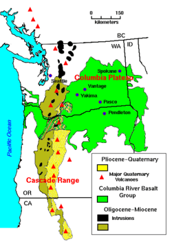
The Columbia Plateau or Columbia Basin[1][2][3] is a geographic region located almost entirely in Eastern Washington and north-central Oregon—with the eastern edge spilling over into Northern Idaho[4] The area is characterized by its mostly semi-arid climate (Bsk under the Köppen classification)—with some areas falling under the desert (BWk) and mediterranean (Csa and Csb) classifications—resulting in a shrub-steppe environment.
Geology
During late Miocene and early Pliocene times, a flood basalt engulfed about 63,000 square miles (160,000 km2) of the Pacific Northwest, forming a large igneous province.[5] Over a period of perhaps 10 to 15 million years, lava flow after lava flow poured out, ultimately accumulating to a thickness of more than 6,000 feet (1.8 km).[5] As the molten rock came to the surface, the Earth's crust gradually sank into the space left by the rising lava. The Columbia River Basalt Group consists of seven formations: The Steens Basalt, Imnaha Basalt, Grande Ronde Basalt, Picture Gorge Basalt, Prineville Basalt, Wanapum Basalt, and Saddle Mountains Basalt. Many of these formations are subdivided into formal and informal members and flows.[6][5]
The subsidence of the crust produced the large plateau—a large, slightly depressed lava plain sometimes also known as the Columbia Basin.[5] The ancient Columbia River was forced into its present course by the northwesterly advancing lava. The lava, as it flowed over the area, first filled the stream valleys, forming dams that in turn caused impoundments or lakes.[5] Entities found in these lake beds include fossil leaf impressions, petrified wood, fossil insects, and bones of vertebrate animals.[5]
Evidence suggests that some concentrated heat source is melting rock beneath the Columbia Plateau Province at the base of the lithosphere (the layer of crust and upper mantle that forms Earth's moving tectonic plates). In an effort to figure out why this area, far from a plate boundary, had such an enormous outpouring of lava, scientists established hardening dates for many of the individual lava flows. They found that the youngest volcanic rocks were clustered near the Yellowstone Plateau, and that the farther west they went, the older the lavas.[7]
Although scientists are still gathering evidence, a probable explanation is that a hot spot, an extremely hot plume of deep mantle material, is rising to the surface beneath the Columbia Plateau Province. Geologists know that beneath Hawaii and Iceland, a temperature instability develops (for reasons not yet well understood) at the boundary between the core and mantle. The concentrated heat triggers a plume hundreds of kilometers in diameter that ascends directly through to the surface of the Earth.[7]
The track of this hot spot starts in the west and sweeps up to Yellowstone National Park. The steaming fumaroles and explosive geysers are ample evidence of a concentration of heat beneath the surface. The hotspot is stationary, but the North American plate is moving over it, creating a superb record of the rate and direction of plate motion.[7]
Flora
Part of the Columbia Plateau is associated with the Columbia Plateau ecoregion, part of the 'Nearctic temperate and subtropical grasslands, savannas, and shrublands' ecoregion of the temperate grasslands, savannas, and shrublands biome.
Geography
Washington cities in the Columbia Plateau include:
Oregon cities in the Columbia Plateau include:
See also
References
- ↑ "Columbia River Basalt Group Stretches from Oregon to Idaho". United States Geological Service. Retrieved March 28, 2018.
- ↑ "Columbia Basin". Washington State Department of Natural Resources. Retrieved March 28, 2018.
- ↑ Floyd, Ben, et al. "Glossary Archived 2005-03-22 at the Wayback Machine.". (1998) Hanford Reach Protection and Management Program Interim Action Plan Archived 2007-09-27 at the Wayback Machine.. Prosser, Washington: Benton County Planning Department.
- ↑ U.S. Geological Survey Geographic Names Information System: Columbia Plateau
- 1 2 3 4 5 6 "Description: Columbia Plateau Columbia River Basalt". United States Geological Survey. Retrieved 2007-10-09.
- ↑ "Columbia River Basalt Group Stretches from Oregon to Idaho". United States Geological Survey. Retrieved 2017-12-28.
- 1 2 3

External links
| Wikivoyage has a travel guide for Columbia River Plateau. |
- USGS Page on Columbia Plateau
- Geology of Lake Roosevelt National Recreation Area (source of much of this page)
- Guide to digital documents and photographs about the Columbia River area.
- Columbia River Basin Ethnic History Archive
Olympia (capital) | |||||||
| Topics |
|  | |||||
| Society | |||||||
| Politics |
| ||||||
| Regions |
| ||||||
| Largest cities |
| ||||||
| Counties |
| ||||||
Coordinates: 45°59′58″N 119°00′05″W / 45.99944°N 119.00139°W