Whidbey Island
| Nickname: "The Rock"[1] | |
|---|---|
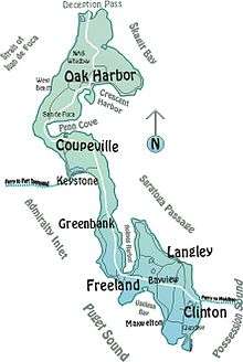 Map of Whidbey Island | |
 Whidbey Island Whidbey Island (Washington) | |
| Geography | |
| Location | Puget Sound |
| Coordinates | 48°08′11″N 122°34′57″W / 48.136389°N 122.5825°WCoordinates: 48°08′11″N 122°34′57″W / 48.136389°N 122.5825°W |
| Area | 168.67 sq mi (436.9 km2) |
| Length | 37 mi (60 km) |
| Width | 10 mi (20 km) |
| Administration | |
|
United States | |
| State | Washington |
| County | Island County |
| Largest settlement | Oak Harbor (pop. 23,204 [2]) |
| Demographics | |
| Population | 80,022 |
| Pop. density | 133.25 /km2 (345.12 /sq mi) |
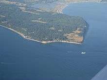
Whidbey Island (historical spellings Whidby, Whitbey,[3] or Whitby) is the largest of the islands composing Island County, Washington, in the United States. (The other large island is Camano Island, east of Whidbey.) Whidbey is about 30 miles (48 km) north of Seattle, and lies between the Olympic Peninsula and the I-5 corridor of western Washington. The island forms the northern boundary of Puget Sound. It is home to Naval Air Station Whidbey Island.
Whidbey Island is home to 80,022 residents (according to the 2000 census).[4] An estimated 29,000 of Whidbey Island residents live in rural locations.
Whidbey Island is approximately 55 miles (89 km) long (if measured along roads traveled from the extreme north to extreme south), or about 37 miles (60 km) when measured along a straight line from north to south, and 1.5 to 10 miles (2.4 to 16.1 km) wide, with a total land area of 168.67 square miles (436.9 km2),[5] making it the 40th largest island in the United States. It is ranked as the fourth longest and fourth largest island in the contiguous United States, behind Long Island, New York;[6][7] Padre Island, Texas (the world's longest barrier island);[8] and Isle Royale, Michigan.[9] In the state of Washington, it is the largest island, followed by Orcas Island.
History
Whidbey Island was inhabited by members of the Lower Skagit, Swinomish, Suquamish, Snohomish and other Native American tribes. The Salishan name for the island was Tscha-kole-chy.[10] These were peaceful groups who lived off the sea and land, with fishing, harvesting nuts, berries and roots, which they preserved over the winter.[11]
The first known European sighting of Whidbey Island was during the 1790 Spanish expedition of Manuel Quimper and Gonzalo López de Haro on the Princesa Real.[12]
Captain George Vancouver fully explored the island in 1792. In May of that year, Royal Navy officers and members of Vancouver's expedition, Joseph Whidbey (master of H. M. S. Discovery) and Peter Puget (a lieutenant on the ship), began to map and explore the areas of what would later be named Puget Sound. After Whidbey circumnavigated the island in June 1792, Vancouver named the island in his honor. By that time, Vancouver had claimed the area for Britain.[13] [14]
The first known overnight stay by a non-Native American was made on May 26, 1840 by a Catholic missionary, Father François Norbert Blanchet, during travel across Puget Sound. He had been invited by Chief Tslalakum.[15] Blanchet remained on the island for nearly a year and guided the inhabitants in building a new log church.[16][15]
Lieutenant Charles Wilkes, commander of the United States Exploring Expedition of 1838–1842, sailed the USS Vincennes into Penn Cove in 1841. By that time, the log church was already being built by the Native Americans beside a huge wooden cross (24 feet long) that they had erected. Wilkes ordered his men to use no force except in self-defense when dealing with the "savage and treacherous inhabitants". In fact, he encountered few problems with the indigenous people who had already been poorly treated by visitors and suffered from diseases they had introduced.[17]
Wilkes named the lower cove Holmes Harbor, after his assistant surgeon, Silas Holmes. During this time he charted Puget Sound.[17] Other sites in the area that were given names by Wilkes included Maury Island (Vashon), Hammersley Inlet, Totten and Budd Inlets, Agate Passage between the Kitsap Peninsula, Hale Passage and Dana Passage.[17]
Thomas W. Glasgow filed the first land claim on Whidbey Island in 1848, attempting to become the first settler. He built a small cabin near Penn Cove, planted some crops and married a local lady, Julia Pat-Ke-Nim.[18] Glasgow left in August of that year however, having been forced out by the local inhabitants.[10] Colonel Isaac N. Ebey arrived from Columbus, Ohio, in 1850 and became the first permanent white settler, claiming a square mile (2.6 km²) of prairie with a southern shoreline on Admiralty Inlet. He took advantage of the 640 acres offered free of charge to each married couple, the first to do so, on October 15, 1850. In the fall of 1851, his children, his wife, three of her brothers and the Samuel Crockett family arrived to join Ebey.[18] In addition to farming potatoes and wheat, Eby was also the postmaster for Port Townsend, Washington and rowed a boat daily across the inlet in order to work at the post office there. Colonel Ebey also served as a representative in the Oregon Territory Legislative Assembly, as Island County's first Justice of the Peace, as a probate judge and as Collector of Customs for the Puget Sound District.[10]
On August 11, 1857, at age 39, Colonel Ebey was murdered and beheaded by Native Americans, said to be Haida who had traveled to this area from the Queen Charlotte Islands. Some sources however, refer to his killers as "Russian Indians called Kakes or Kikans, [from] Kufrinoff Island, near the head of Prince Frederick's Sound.[18] Ebey was slain in proxy-retaliation for the killing of a Haida chief or Tyee and 27 other indigenous people at Port Gamble. Fort Ebey, named for the Colonel, was established in 1942 on the west side of the central part of the island, just northwest of Coupeville.[10]
Admiralty Head Lighthouse is located in this area, on the grounds of Fort Casey State Park. The area around Coupeville is the federally protected Ebey's Landing National Historical Reserve, named in honor of Isaac Ebey.
In December 1984, the island was the site of a violent encounter between law enforcement and white nationalist and organized crime leader Robert Jay Mathews of the group The Order. A large shootout occurred between Mathews and FBI agents in which Mathews was killed during a house fire. Mathews' followers have since gathered on the island at the location where he was killed by FBI agents on the anniversary of his death to commemorate it.[19]
Government
Whidbey Island, along with Camano Island, Ben Ure Island and six uninhabited islands, comprises Island County, Washington. The county seat is located in the town of Coupeville on Whidbey Island.
Population centers of Whidbey Island include the City of Oak Harbor, the Town of Coupeville, the City of Langley, the Village of Freeland, the Community of Greenbank, the Village of Clinton and the Community of Bayview. Only Oak Harbor, Coupeville and Langley are incorporated, the others (with the exception of Greenbank and Bayview) are all Census-designated places, and all but Bayview have their own post offices and ZIP codes.
Economy

Whidbey Island is divided economically into two different regions: the northern end of the island (encompassing Oak Harbor and Whidbey Island Naval Air Station), and the remainder of the island (encompassing Coupeville, Greenbank, Freeland, Langley, Clinton and the smaller communities in-between).
The economy of the northern end of Whidbey Island is strongly influenced by the presence of Whidbey Island Naval Air Station near Oak Harbor (N.A.S. Whidbey). N.A.S. Whidbey is Oak Harbor's largest employer; thus, Oak Harbor has a predominantly service-based economy and several national chain stores have been attracted to the Oak Harbor area.
The economy of Whidbey Island south of Oak Harbor relies heavily on tourism, small-scale agriculture, and the arts.
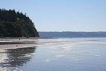
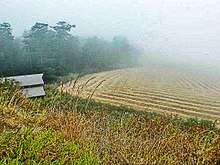
Tourism is especially important for both Whidbey and Camano Islands. On Whidbey, tourists find a wide range of amenities in the towns of Oak Harbor, Coupeville, Freeland and Langley. Coupeville's Penn Cove Mussel Farm exports large quantities of its highly renowned Penn Cove Mussels. This aquaculture facility, along with a number of small farms, reflects the rural agricultural nature of most of central Whidbey Island. Many of these small farms host farm stands onsite, where customers may buy produce, flowers, meat, eggs and other locally raised products directly from the farmers.[20]
Often referred to as Puget Sound's Largest Artist's Colony, Whidbey is home to numerous working artists, writers, and performers. These include many well-known painters, sculptors, glass artists, wood workers, metal workers, mixed media artists, photographers, authors, poets, actors, and musicians.
In addition to being a haven for artists, the southern end of Whidbey Island also serves as a minor bedroom community for the nearby cities of Everett, where the Boeing Everett Factory is located, and Seattle. Commuters to and from those areas use the Washington State Ferries system's run between Clinton and Mukilteo.
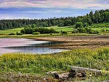
Geography
Whidbey Island is often claimed to be the longest island in the continental United States (or another similar claim), but according to the Seattle Times it cannot be correctly considered so.[21] Whidbey Island has four lakes that are part of its interior hydrology: Cranberry Lake (inside Deception Pass State Park), Deer Lake, Goss Lake and Lone Lake (both near the town of Langley).[22]
Parks and reserve areas
Whidbey Island contains Ebey's Landing National Historical Reserve, the first national historic reserve in the US created by the National Park Service to preserve the rural history and culture of the island and to protect the area's rare and sensitive plants.
Washington State Parks located on the island include Deception Pass State Park (the most visited state park in Washington), Joseph Whidbey State Park, Fort Ebey State Park, Fort Casey State Park, Possession Point State Park, and South Whidbey Island State Park. There is also a series of county operated parks throughout the Island.
Earth Sanctuary is a nature reserve, sculpture garden and retreat center on Whidbey Island. The ponds and bog fen complex have been designated as a "habitat of local importance" by the Whidbey Audubon Society and Island County Critical Areas program.[23][24]
Festivals
Whidbey Island hosts many festivals and celebrations throughout the year.
- Whidbey Island Area Fair ("Island County Fair" until 2012[25]), on the third weekend of August, includes rides, food, and animal shows.
- Wag'n'Walk, which takes place towards the end of August, is Western Washington's premier celebration of dogs and things dog-related. It includes vendors, games, competition, demonstrations and the Wag'n'Walk itself.
- Whidbey Island Kite Festival, in September
- Langley's Mystery Weekend in March or February. For the weekend the Town of Langley turns into the setting of a fictional murder mystery.
- Penn Cove Mussel Festival, in March, celebrates the bounty of the sea, especially the mussel.
- Loganberry Festival at the Greenbank Farm in July (This was discontinued after the 2016 festival.)
- Maxwelton Beach Fourth of July Parade and fireworks show, which takes place at the southern end of Maxwelton Road at Dave Mackie Park. After the parade, there are events for all ages, including three-legged races, divided into age groups, and the most popular event, the egg toss.
- Choochokam is the annual street fair and arts festival, held in downtown Langley during the second weekend of July, detailed schedules and other information is generally available on the festival website. (This was discontinued after the 2016 festival.)
- Tour de Whidbey, in September, is a bike race spanning the length of Whidbey Island.
- The Whidbey Island Marathon and Half Marathon, in April since 2002.[26]
- Whidbey Island Race Week: a week-long sailing regatta every summer based out of Oak Harbor with daily racing in Penn Cove and/or Saratoga Passage (depending on wind conditions). Usually held third week of July, varies slightly due to tidal conditions.
- Whidbey Island Highland Games - 2nd Saturday in August. Competitions in Scottish Heavy Athletics, Highland Dancing, Pipe and drum bands.
- Whidbey Island Zucchini Festival - An annual festival hosted by residents of Whidbey island brought about by an excess of home-grown zucchini. The festival includes zucchini based musical performances, various types of zucchini based or themed visual art, all types of foods that feature zucchini, outdoor games and competitions using zucchini, and a giant zucchini slingshot.
- Oak Harbor Music Festival - An annual music festival held in the biggest city on the island, Oak Harbor. It is held over Labor Day Weekend, and consists of a wide variety of musical acts.
- DjangoFestNW - An annual 5-day music festival held in mid-September that celebrates the music of Django Reinhardt at Whidbey Island Center for the Arts[27]
Climate
Whidbey Island lies partially in the rain shadow of the Olympic Mountain Range to the west, and has a variety of climate zones. This can be observed by rainfall amounts – wettest in the south with average rainfall of 36 inches (910 mm), driest in the central district of Coupeville with average rainfall of 20 to 22 inches (510 to 560 mm), and turning moister again farther north with average rainfall of 32 inches (810 mm). Microclimates abound, determined by proximity to water, elevation and prevailing winds.
| Climate data for Whidbey Island NAS (1981−2010 normals) | |||||||||||||
|---|---|---|---|---|---|---|---|---|---|---|---|---|---|
| Month | Jan | Feb | Mar | Apr | May | Jun | Jul | Aug | Sep | Oct | Nov | Dec | Year |
| Average high °F (°C) | 46.8 (8.2) |
48.9 (9.4) |
52.2 (11.2) |
55.6 (13.1) |
59.5 (15.3) |
63.6 (17.6) |
66.5 (19.2) |
67.3 (19.6) |
64.0 (17.8) |
57.2 (14) |
50.3 (10.2) |
45.5 (7.5) |
56.5 (13.6) |
| Average low °F (°C) | 36.2 (2.3) |
35.4 (1.9) |
38.4 (3.6) |
41.5 (5.3) |
46.1 (7.8) |
50.0 (10) |
52.1 (11.2) |
51.8 (11) |
48.0 (8.9) |
43.2 (6.2) |
39.2 (4) |
35.1 (1.7) |
43.1 (6.2) |
| Average precipitation inches (mm) | 2.23 (56.6) |
1.47 (37.3) |
1.67 (42.4) |
1.65 (41.9) |
1.56 (39.6) |
1.28 (32.5) |
0.74 (18.8) |
0.96 (24.4) |
1.15 (29.2) |
2.07 (52.6) |
3.40 (86.4) |
2.11 (53.6) |
20.29 (515.4) |
| Average snowfall inches (cm) | 0.9 (2.3) |
1.5 (3.8) |
0.1 (0.3) |
0.1 (0.3) |
0.0 (0) |
0.0 (0) |
0.0 (0) |
0.0 (0) |
0.0 (0) |
0.0 (0) |
0.9 (2.3) |
1.7 (4.3) |
5.2 (13.2) |
| Average precipitation days (≥ 0.01 in) | 16.4 | 10.7 | 11.5 | 11.9 | 10.0 | 5.9 | 3.7 | 3.8 | 4.1 | 12.6 | 20.7 | 17.3 | 144.7 |
| Average snowy days (≥ 0.1 in) | 1.0 | 0.5 | 0.1 | 0.0 | 0.0 | 0.0 | 0.0 | 0.0 | 0.0 | 0.0 | 0.4 | 0.9 | 2.9 |
| Source: NOAA[28] | |||||||||||||
Ecology
Flora
Vegetation varies greatly from one end of the island to the other. Vegetation in the south is more similar to that of mainland Washington. The principal trees are Douglas fir, red alder, bigleaf maple, western red cedar, and western hemlock. Compared to the rest of western Washington state, vine maple is notably absent, except where they have been planted. Other under-story plants include the evergreen huckleberry, lower longleaf Oregon grape, elderberry, salal, oceanspray, and varieties of nettle. Non-native introduced plants such as foxglove, ivy and holly are also evident.
Farther up the island, however, the shorter Oregon-Grape and the blue Evergreen Huckleberry is seen less, while tall Oregon-grape and Red Huckleberry predominate. The native Pacific rhododendron is much more visible. Amongst the deciduous varieties, Garry oak (from which Oak Harbor takes its name) are seen more frequently in the northern portion of the island and Pacific madrone is also notably present. In the conifer classification, grand fir is found more in the northern part of Whidbey Island along with Sitka spruce and shore pine. There are three open prairie areas on Whidbey Island – Smith Prairie, Crockett Prairie and Ebey Prairie. Some patches of prickly pear cactus are found along the slopes near Partridge Point.
Fauna
Gray whales migrate between Whidbey and Camano Islands during March and April and can be seen from both ship and shore.[29] Orca also make use of the waters surrounding Whidbey Island.
Clams and Oysters are abundant locally and may be harvested from some public beaches.[30] The Washington State Department of Health provides an online guide to assist in identifying shellfish varieties as well as providing guidance about where to find specific varieties.[31]
Education
Public school districts
Whidbey Island is served by three public school districts.
Oak Harbor School District operates in Oak Harbor. Within the district, there is one high school, one alternative high school, two middle schools, and five elementary schools. Within the Washington Interscholastic Activities Association, Oak Harbor High is listed as a 3-A school.
Coupeville School District operates in Coupeville, Washington and Greenbank, Washington. Within the district, there is one high school, one middle school, and one elementary school. Within the Washington Interscholastic Activities Association, Coupeville High is listed as a 1-A school.
South Whidbey School District serves the southern end of the island, including Freeland, Langley, and Clinton. Within the district, there is one high school (grades 9–12), one alternative school (grades K–12), one middle school (grades 5-8) split between 2 campuses, and one elementary school (grades K–4). Within the Washington Interscholastic Activities Association, South Whidbey High is listed as a 1-A school.
Colleges
Skagit Valley College has a campus located in Oak Harbor, and a limited service campus in South Whidbey.
Seattle Pacific University owns Camp Casey, a retreat center near Coupeville, which was once the barracks for the adjacent Fort Casey.
Notable people
Politicians
- Jack Metcalf (1927-2007), United States House of Representatives, grew up on Whidbey Island in the 1930s.[32]
Writers and artists
- Shayla Beesley, actress, grew up in Oak Harbor
- Juliet Winters Carpenter, prize-winning translator of Japanese literature and author
- Aleah Chapin, painter, grew up on Whidbey Island
- Pete Dexter, National Book Award fiction writer
- Elizabeth George, mystery author.
- Aaron Parks, jazz pianist.
- David Ossman, founder of Firesign Theater
- Nancy Horan, best selling author
- Jeff Alexander, conductor and arranger
- Eli Moore and Ashley Eriksson of Lake
- David Whyte, poet
Other
- Robert Jay Mathews, American neo-Nazi terrorist and the leader of The Order (white supremacist group), an American white supremacist militant group, died on Whidbey Island during a shoot-out with federal law enforcement agents.
- Bruce Bochte, American baseball player. Bochte lived on Whidbey Island for over three years after his baseball playing days were over.[33]
- Marti Malloy, London 2012 Olympic Bronze medalist, Judo women's 57 kg
Infrastructure
Transportation
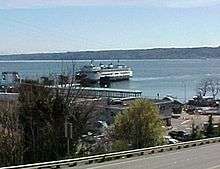
The only bridge that reaches Whidbey Island is the Deception Pass Bridge, State Route 20, which connects the north end of Whidbey to the mainland via Fidalgo Island. Prior to the completion of the bridge in 1935, Whidbey Island was linked to Fidalgo Island by the Deception Pass ferry, which ran from 1924 to 1935. Modern ferry service is available via State Route 20 on the Coupeville to Port Townsend ferry, and via State Route 525 on the Clinton to Mukilteo ferry service on the southern east coast.
Travel on the island involves use of an extensive county road system, or city infrastructure depending on location, all of which act as feeders to the two state highways State Route 525 and State Route 20.
Whidbey Island's State Routes 525/20 is the only nationally designated Scenic Byway on an island. It is appropriately named the "Whidbey Island Scenic Isle Way."
Public transportation is provided by Island Transit, which provides a zero-fare bus service paid for by a 6/10th of 1% sales tax within the county. There are currently 11 bus routes serving Whidbey Island. No service is available on Sundays or major holidays.
Two public airports provide service to Whidbey Island. Whidbey Air Park is located 2 miles (3.2 km) southwest of Langley with a 2,470 feet (750 m) long runway. Wes Lupien Airport is located 3 miles (4.8 km) southwest of Oak Harbor with a 3,265 ft (995 m) long runway. In addition, there are approximately half dozen private dirt strips on the island. Kenmore Air Express ran a scheduled airline service to Whidbey Island serving the Oak Harbor airport from 2006 to 2009.[34]
The United States Navy operates two airports on Whidbey Island. The largest is a two-runway airport located at Whidbey Island Naval Air Station north of Oak Harbor. In addition, the Navy also operates a flight training facility named Coupeville Outlying Landing Field (Coupeville OLF) located just southeast of Coupeville. The Navy named USS Whidbey Island (LSD-41) in honor of the island.
Health systems
Whidbey Health is the regional, county-run hospital. Located in Coupeville, the hospital has an extension clinic in Oak Harbor. The Naval Air Station in Oak Harbor has a limited service hospital for military personnel, veteran retirees, and their dependents.
Communities
North to south:
- Deception Pass
- Oak Harbor - Largest city
- West Beach
- San De Fuca
- Coupeville – County Seat
- Keystone
- Admiral's Cove
- Lagoon Point
- Greenbank
- Langley
- Freeland
- Bayview
- Clinton
- Maxwelton
- Glendale
See also
References
- ↑ "Whidbey Island has a terrain that's set in stone". Whidbey News-Times. July 3, 2008. Archived from the original on September 19, 2015. Retrieved February 10, 2012.
- ↑ United States Census Bureau
- ↑ "Whidbey Island". Geographic Names Information System. United States Geological Survey.
- ↑ Island County, Washington and its subdivisions United States Census Bureau
- ↑ "Island County Assessor". Island County Assessor. Retrieved February 16, 2015.
- ↑ John Burbidge (November 21, 2004). "Long Island at its Best; Who's the Longest of Them All?". The New York Times. Retrieved 2008-10-16.
- ↑ "The Longest Islands in the United States - Peakbagger.com". www.peakbagger.com.
- ↑ "Padre Island National Seashore (U.S. National Park Service)". www.nps.gov.
- ↑ "Isle Royale National Park - National Geographic". nationalgeographic.com. November 5, 2009.
- 1 2 3 4 "Island County -- Thumbnail History". historylink.org.
- ↑ "Tschakolecy - Whidbey Island History: Tschakolecy". whidbeyhistory.historywiz.org.
- ↑ Hayes, Derek (1999). Historical Atlas of the Pacific Northwest: Maps of exploration and Discovery. Sasquatch Books. pp. 70–71. ISBN 1-57061-215-3.
- ↑ "Archived copy". Archived from the original on August 18, 2017. Retrieved August 23, 2017.
- ↑ "Joseph Whidbey circumnavigates Whidbey Island in June 1792. - HistoryLink.org". www.historylink.org.
- 1 2 "Father Francis (or Francois) N. Blanchet visits Whidbey Island on May 26, 1840. - HistoryLink.org". www.historylink.org.
- ↑ 40220Olympia, Contact Us Washington Secretary of StateLegacy WashingtonLegislative Building · PO Box; Policy, WA 98504-0220Phone Numbers Privacy. "Legacy Washington - WA Secretary of State". wa.gov.
- 1 2 3 "Wilkes, Charles (1798-1877)". historylink.org.
- 1 2 3 "Archived copy". Archived from the original on April 25, 2017. Retrieved August 23, 2017.
- ↑ "Robert Jay Mathews, founder of the white-supremacist group The Order, is killed during an FBI siege on Whidbey Island on December 8, 1984". historylink.org.
- ↑ "Archived copy" (PDF). Archived from the original (PDF) on July 1, 2015. Retrieved January 19, 2016.
- ↑ Johnston, Steve (January 5, 2000). "Whidbey is long, but let's not stretch it". The Seattle Times. Retrieved August 25, 2011.
- ↑ "Lakes Monitored by Ecology's Lake Water Quality Monitoring Program From 1989 through 1997". Department of Ecology, State of Washington. Retrieved August 25, 2011.
- ↑ "ISLAND BIRDING - Islanders should speak up now to protect important bird habitat areas". South Whidbey Record. Retrieved February 16, 2015.
- ↑ "Newman Ponds to become 'Earth Sanctuary'". South Whidbey Record. Retrieved February 16, 2015.
- ↑ "Welcome to the new Whidbey Island Fair - South Whidbey Record". southwhidbeyrecord.com. April 27, 2012.
- ↑ "Archived copy". Archived from the original on November 23, 2002. Retrieved February 25, 2008.
- ↑ "Welcome". DjangofestNW.com.
- ↑ "WA Whidbey Island NAS". National Oceanic and Atmospheric Administration. Retrieved 28 May 2014.
- ↑ "Whale Watching around Whidbey and Camano Islands". Whidbey and Camano Islands. Retrieved 2018-03-08.
- ↑ "Map data". wdfw.wa.gov.
- ↑ "Shellfish Identification :: Washington State Department of Health" (PDF). www.doh.wa.gov.
- ↑ Jack Metcalf obituary Archived March 19, 2007, at the Wayback Machine., Seattle Times, March 16, 2007
- ↑ "Bochte has moved a long way from baseball". seattlepi.com.
- ↑ "Archived copy". Archived from the original on October 7, 2008. Retrieved August 4, 2009.
External links
| Wikimedia Commons has media related to Whidbey Island. |
| Wikivoyage has a travel guide for Whidbey Island. |
- Whidbey Island & Camano Island Official Tourism Website
- University of Washington Libraries Digital Collections – Oliver S. Van Olinda Photographs A collection of 420 photographs depicting life on Vashon Island, Whidbey Island, Seattle and other communities of Washington State's Puget Sound from the 1880s to the 1930s.
