Yakima, Washington
| Yakima | ||
|---|---|---|
| City | ||
| City of Yakima | ||
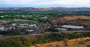 Yakima as viewed from Lookout Point | ||
| ||
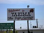
| Nickname(s): The Palm Springs of Washington; The Heart of Central Washington | ||
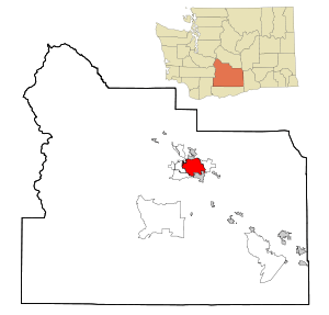 Location of Yakima in Washington | ||
 Yakima Location in the United States | ||
| Coordinates: 46°36′N 120°30′W / 46.600°N 120.500°W | ||
| Country |
| |
| State |
| |
| County | Yakima | |
| Incorporated | December 10, 1883 | |
| Government | ||
| • Type | Council-Manager | |
| • Manager | Cliff Moore | |
| • Mayor | Kathy Coffey | |
| Area[1] | ||
| • City | 71.72 km2 (27.69 sq mi) | |
| • Land | 70.40 km2 (27.18 sq mi) | |
| • Water | 1.32 km2 (0.51 sq mi) 1.84% | |
| Elevation | 325 m (1,066 ft) | |
| Population (2010)[2] | ||
| • City | 91,067 | |
| • Estimate (2015)[3] | 93,701 | |
| • Rank | US: 331st | |
| • Density | 1,293.6/km2 (3,350.5/sq mi) | |
| • Urban | 129,534 (US: 248th) | |
| • Metro | 248,830 (US: 188th) | |
| Time zone | UTC−8 (PST) | |
| • Summer (DST) | UTC−7 (PDT) | |
| Zip Code | 98901, 98902, 98903, 98904, 98907, 98908, 98909 | |
| Area code(s) | 509 | |
| FIPS code | 53-80010 | |
| GNIS feature ID | 1509643[4] | |
| Website | www.yakimawa.gov | |
Yakima (/ˈjækɪmɑː/ or /ˈjækɪmə/) is a city in and the county seat of Yakima County, Washington, and the state's eleventh-largest city by population. As of the 2010 census, the city had a total population of 91,067 and a metropolitan population of 243,231.[5] The unincorporated suburban areas of West Valley and Terrace Heights are considered a part of greater Yakima.[6]
Yakima is about 60 miles (100 kilometers) southeast of Mount Rainier in Washington. It is situated in the Yakima Valley, a productive agricultural region noted for apple, wine and hop production. As of 2011, the Yakima Valley produces 77% of all hops grown in the United States.[7] The name Yakima originates from the Yakama Nation Native American tribe, whose reservation is located south of the city.
History
The Yakama people were the first known inhabitants of the Yakima Valley. In 1805, the Lewis and Clark Expedition came to the area and discovered abundant wildlife and rich soil, prompting the settlement of homesteaders.[8] A Catholic Mission was established in Ahtanum, southwest of present-day Yakima, in 1847.[9] The arrival of settlers and their conflicts with the natives resulted in the Yakima War. The U.S. Army established Fort Simcoe in 1856 near present-day White Swan as a response to the uprising. The Yakamas were defeated and forced to relocate to the Yakama Indian Reservation.
Yakima County was created in 1865. When bypassed by the Northern Pacific Railroad in December 1884, over 100 buildings were moved with rollers and horse teams to the nearby site of the depot. The new city was dubbed North Yakima and was officially incorporated and named the county seat on January 27, 1886. The name was changed to Yakima in 1918. Union Gap was the new name given to the original site of Yakima.
Geography
According to the United States Census Bureau, the city has a total area of 27.69 square miles (71.72 km2), of which, 27.18 square miles (70.40 km2) is land and 0.51 square miles (1.32 km2) is water.[1] Yakima is 1095 feet above mean sea level.
Yakima region
The city of Yakima is located in the Upper Valley of Yakima County. The county is geographically divided by Ahtanum Ridge and Rattlesnake Ridge into two regions: the Upper (northern) and Lower (southern) valleys. Yakima is located in the more urbanized Upper Valley, and is the central city of the Yakima Metropolitan Statistical Area.
Surrounding municipalities | |
|---|---|
The unincorporated suburban areas of West Valley and Terrace Heights are considered a part of greater Yakima. Other nearby cities include Moxee, Tieton, Cowiche, Wiley City, Tampico, Gleed, and Naches in the Upper Valley, as well as Wapato, Toppenish, Zillah, Harrah, White Swan, Parker, Buena, Outlook, Granger, Mabton, Sunnyside, and Grandview in the Lower Valley.
Bodies of water
The primary irrigation source for the Yakima Valley, the Yakima River, runs through Yakima from its source at Lake Keechelus in the Cascade Range to the Columbia River at Richland. In Yakima, the river is used for both fishing and recreation. A 10-mile (16 km) walking and cycling trail, a park, and a wildlife sanctuary are located at the river's edge.
The Naches River forms the northern border of the city. Several small lakes flank the northern edge of the city, including Myron Lake, Lake Aspen, Bergland Lake (private) and Rotary Lake (also known as Freeway Lake). These lakes are popular with fishermen and swimmers during the summer.
Climate
Yakima has a semi-arid climate (Köppen BSk) with a Mediterranean precipitation pattern. Winters are cold, with December the coolest month, with a mean temperature of 28.5 °F (−1.9 °C).[10] Annual average snowfall is 21.7 inches or 0.55 metres,[10] with most occurring in December and January, when the snow depth averages 2 to 3 inches or 0.051 to 0.076 metres. There are 22 afternoons per year in which the high does not surpass freezing, and 2.3 mornings where the low is 0 °F (−17.8 °C) or lower.[10] Springtime warming is very gradual, with the average last freeze of the season May 13. Summer days are hot, but the diurnal temperature variation is large, exceeding 35 °F (19.4 °C), sometimes reaching as high as 50 °F (27.8 °C) during that season; there are 34 afternoons of 90 °F (32.2 °C)+ highs annually and 3.2 afternoons of 100 °F (37.8 °C)+ highs. Autumn cooling is very rapid, with the average first freeze of the season occurring on September 30. Due to the city's location in a rain shadow, precipitation, at an average of 8.22 inches or 209 millimetres annually, is low year-round,[10] but especially during summer. Extreme temperatures have ranged from −25 °F (−31.7 °C) on February 1, 1950, to 110 °F (43.3 °C) on August 10, 1971.[11]
| Climate data for Yakima, Washington (1981–2010 normals) | |||||||||||||
|---|---|---|---|---|---|---|---|---|---|---|---|---|---|
| Month | Jan | Feb | Mar | Apr | May | Jun | Jul | Aug | Sep | Oct | Nov | Dec | Year |
| Record high °F (°C) | 68 (20) |
69 (21) |
80 (27) |
92 (33) |
102 (39) |
108 (42) |
109 (43) |
110 (43) |
100 (38) |
91 (33) |
73 (23) |
67 (19) |
110 (43) |
| Average high °F (°C) | 38.6 (3.7) |
46.3 (7.9) |
56.2 (13.4) |
63.8 (17.7) |
72.4 (22.4) |
79.5 (26.4) |
87.9 (31.1) |
86.8 (30.4) |
78.0 (25.6) |
63.9 (17.7) |
47.9 (8.8) |
35.8 (2.1) |
63.1 (17.3) |
| Average low °F (°C) | 23.3 (−4.8) |
25.9 (−3.4) |
30.1 (−1.1) |
34.4 (1.3) |
41.9 (5.5) |
48.3 (9.1) |
53.3 (11.8) |
51.8 (11) |
43.5 (6.4) |
34.1 (1.2) |
26.8 (−2.9) |
21.3 (−5.9) |
36.2 (2.3) |
| Record low °F (°C) | −21 (−29) |
−25 (−32) |
−1 (−18) |
18 (−8) |
25 (−4) |
30 (−1) |
34 (1) |
35 (2) |
24 (−4) |
4 (−16) |
−13 (−25) |
−17 (−27) |
−25 (−32) |
| Average precipitation inches (mm) | 1.13 (28.7) |
.78 (19.8) |
.62 (15.7) |
.55 (14) |
.58 (14.7) |
.62 (15.7) |
.21 (5.3) |
.26 (6.6) |
.36 (9.1) |
.53 (13.5) |
1.05 (26.7) |
1.53 (38.9) |
8.22 (208.7) |
| Average snowfall inches (cm) | 5.5 (14) |
2.5 (6.4) |
.7 (1.8) |
0 (0) |
0 (0) |
0 (0) |
0 (0) |
0 (0) |
0 (0) |
.1 (0.3) |
3.4 (8.6) |
9.4 (23.9) |
21.7 (55.1) |
| Average precipitation days | 9.5 | 7.5 | 6.4 | 5.8 | 6.2 | 5.2 | 2.4 | 2.3 | 3.2 | 4.7 | 8.6 | 10.1 | 71.9 |
| Average snowy days | 4.3 | 2.2 | .7 | .1 | 0 | 0 | 0 | 0 | 0 | .1 | 1.7 | 6.2 | 15.3 |
| Source: NOAA (extremes 1946–present)[10] | |||||||||||||
Demographics
| Historical population | |||
|---|---|---|---|
| Census | Pop. | %± | |
| 1890 | 1,535 | — | |
| 1900 | 3,154 | 105.5% | |
| 1910 | 14,082 | 346.5% | |
| 1920 | 18,539 | 31.7% | |
| 1930 | 22,101 | 19.2% | |
| 1940 | 27,221 | 23.2% | |
| 1950 | 38,486 | 41.4% | |
| 1960 | 43,284 | 12.5% | |
| 1970 | 45,588 | 5.3% | |
| 1980 | 49,826 | 9.3% | |
| 1990 | 54,827 | 10.0% | |
| 2000 | 71,845 | 31.0% | |
| 2010 | 91,067 | 26.8% | |
| Est. 2016 | 93,986 | [12] | 3.2% |
| U.S. Decennial Census[13] 2015 Estimate[3] | |||
2010 census
As of the census of 2010, there were 91,067 people with 33,074 households, and 21,411 families residing in the city. The population density was 3,350.5 people per square mile. There were 34,829 housing units at an average density of 1,281.4 per square mile. The racial makeup of the city was 67.1% Caucasian, 1.7% African American, 2.0% Native American, 1.5% Asian, 0.1% Pacific Islander, 23.3% from other races, and 4.4% from two or more races. 41.3% were Hispanic or Latino, of any race.[14][15] 19.1% of the population had a bachelor's degree or higher.[16]
There were 33,074 households of which 33.2% had children under the age of 18 living with them, 44.7% were married couples living together, 15.7% had a female householder with no husband present, 6.3% had a male householder with no wife present, and 35.3% were non-families. 28.7% of all households were made up of individuals and 11.9% had someone living alone who was 65 years of age or older. The average household size was 2.68 and the average family size was 3.3.
28.3% of the population was under the age of 18 and 13.1% were 65 years or older. The median age was 33.9 years. 50.7% of the population was female.
The median household income was $39,706. The per capita income was $20,771. 21.3% of the population were below the poverty line.
Government
Yakima is one of the ten First Class Cities, those with a population over 10,000 at the time of reorganization and operating under a home rule charter. They are permitted to perform any function specifically granted them by Title 35 RCW (Revised Code of Washington).
Local government
The Yakima City Council operates under the council-manager form of government. The city council has seven members, elected by district and the mayor is elected by the council members. Yakima's City Manager serves under the direction of the City Council, and administers and coordinates the delivery of municipal services. The city of Yakima is a full-service city, providing police, fire, water and wastewater treatment, parks, public works, planning, street maintenance, code enforcement, airport and transit to residents.
- All-America City Award. In 1994 and 2015, the City of Yakima received the All-America City Award, given by the National Civic League. Ten U.S. cities receive this award per year.
State government
The citizens of Yakima are represented in the Washington Senate by Republicans Curtis King in District 14, and Jim Honeyford in District 15, and in the Washington House of Representatives by Republicans Norm Johnson and Gina Mosbrucker in District 14, and Republicans Bruce Chandler and David Taylor in District 15.
National government
At the national level, the two U.S. senators from Washington are Democrats Patty Murray and Maria Cantwell; Yakima is part of Washington's US Congressional 4th District, currently represented by Republican Dan Newhouse.
Culture
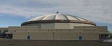
Cultural activities and events take place throughout the year. The Yakima Valley Museum houses exhibits related to the region's natural and cultural history, a restored soda fountain, and periodic special exhibitions. Downtown Yakima's historic Capitol Theatre and Seasons Performance Hall, as well as the West-side's Allied Arts Center, present numerous musical and stage productions. Larson Gallery housed at Yakima Valley Community College present six diverse art exhibitions each year. The city is home to the Yakima Symphony Orchestra. The Yakima Area Arboretum is a botanical garden featuring species of both native and adapted non-native plants. Popular music tours, trade shows, and other large events are hosted at the Yakima SunDome in State Fair Park.
The film The Hanging Tree (1959) was shot entirely in and around Yakima.[17]
Festivals and fairs
- Central Washington State Fair, held each year in late September at State Fair Park.
- Yakima Folklife Festival,[18] held the second week of July at Franklin Park.
- Fresh Hop Ale Festival,[19] held each October in Downtown Yakima.
- A Case of the Blues and All That Jazz,[20] held in August in Sarg Hubbard Park.
Sports
- The Yakima Mavericks are a Minor League football team in the Pacific Football League and plays at Marquette Stadium.
- The Yakima Beetles American Legion baseball team, 3-time World Champions.
- The Yakima Valley Pippins are a collegiate wood bat baseball team that play in the West Coast League.
- Former professional teams
- The Yakima Valley Warriors were an indoor football team. Play ended 2010
- The Yakima Sun Kings was a Continental Basketball Association franchise that won 5 CBA championships and disbanded in 2008. The team was reinstituted in 2018 as part of the North American Premier Basketball league.
- The Yakima Bears minor league baseball team, moved to Oregon after the 2011 season.
- The Yakima Reds American soccer team played in the USL Premier Development League disbanded in 2010.
Transportation
Roads and highways
Interstate 82 is the main highway through Yakima. The highway runs north and south, but is sign-posted east and west. Northbound traffic is posted west, since this heads towards Seattle, and southbound traffic is posted east since this heads towards Salt Lake City. U.S. Route 12 crosses through the city from White Pass. U.S. Route 97 joins I-82 from Yakima for approximately 40 miles (64 km) north to Ellensburg. State Route 24 terminates at Yakima and is the primary means of reaching Moxee City and many of the area's agricultural areas to the east. State Route 821 terminates near Yakima and is also called Canyon Road because it passes through the Yakima River canyon. It is an alternate route to Ellensburg which bypasses the I-82 summit at Manastash Ridge.
Public transport
City-owned Yakima Transit serves Yakima, Selah, West Valley and Terrace Heights, as well as several daily trips to Ellensburg. There are also free intercity bus systems between adjacent Union Gap and nearby Toppenish, Wapato, White Swan, and Ellensburg.[21]
Airport
Yakima is served by the Yakima Air Terminal, a municipal airport located on the southern edge of the city and is used for general aviation and commercial air service. The FAA identifier is YKM. It has two asphalt runways: 9/27 is 7,604 by 150 feet (2,318 x 46 m) and 4/22 is 3,835 by 150 feet (1,169 x 46 m). Yakima Air Terminal is owned and operated by the city.
Yakima is served by one scheduled air carrier (Alaska Airlines) and two non-scheduled carriers (Sun Country Airlines and Xtra Airways). Alaska Airlines provides multiple daily flights to and from Seattle-Tacoma International Airport, Sun Country Airlines provide charter flights to Laughlin, NV and Xtra Airways provide charter flights to Wendover, NV. During World War II the airfield was used by the United States Army Air Forces.
The airport at is home to numerous private aircraft, and is a popular test site for military jets and Boeing test flights. Several businesses are located at the airport including Hertz Car Rental, Budget Rent a Car, Airporter Shuttle, Cub Crafters and several freight companies.
Economy
Yakima's growth in the 20th century was fueled primarily by agriculture. The Yakima Valley produces many fruit crops, including apples, peaches, pears, cherries, and melons. Many vegetables are also produced, including peppers, corn and beans. Most of the nation's hops, a key ingredient in the production of beer, are also grown in the Yakima Valley. Many of the city's residents have come to the valley out of economic necessity and to participate in the picking, processing, marketing and support services for the agricultural economy.
| Largest employers in the Yakima area[22] | |||
|---|---|---|---|
| Employer | Type | Persons employed | |
| 1. Yakima Valley Memorial Hospital | Hospital | 2,200 | |
| 2. Yakima School District | School district (Education) | 1,736 | |
| 3. Walmart | Department store | 1,587 | |
| 4. Washington State Department of Social and Health Services | State government (Social services) | 1,400 | |
| 5. Yakima County | County government | 1,213 | |
| 6. Del Monte Foods | Fruit processing | 1,200 | |
| 7. Yakima Valley Farm Workers Clinic | Hospital | 1,181 | |
| 8. Yakima Regional Medical & Cardiac Center | Hospital | 942 | |
| 9. Yakima Training Center | United States Army (Military) | 850 | |
| 10. AB Foods | Beef processing | 850 | |
| 11. Yakima Valley College | Education | 761 | |
| 12. City of Yakima | City government | 711 | |
| 13. Yakama Legends Casino | Casino | 634 | |
| 14. Washington State Department of Transportation | State government | 555 | |
| 15. Tree Top, Inc. | Fruit processing | 540 | |
Downtown Yakima, long the retail hub of the region, has undergone many changes since the late 1990s. Three major department stores, and an entire shopping mall that is now closed, have been replaced by a Whirlpool Corporation facility, an Adaptis call center, and several hotels.
The region's retail core has shifted to the town of Union Gap, where a renovated shopping mall and other new retail businesses are flourishing. While some see big-box retail leaving the downtown area as a loss, others see it as an opportunity to recast the downtown area as a center for events, services, entertainment, and smaller, more personal shopping experiences. One part of this effort has been the Downtown Futures Initiative.[23] The DFI has provided for street-to-storefront remodeling along Yakima Avenue throughout the entire downtown core, and includes new pedestrian-friendly lighting, water fountains, planters, banner poles and new trees and hanging baskets, all of which complement the new paver-inlaid sidewalks.
Events held downtown include Yakima Downtown New Year's Eve, a Cinco de Mayo celebration, Yakima Live music festival, Yakima Summer Kickoff Party, Fresh Hop Ale Fest,[19] a weekly Farmers' Market,[24] and the Hot Shots 3-on-3 Basketball Tournament.[25]
A bright spot in the economy of the Yakima Valley is the burgeoning wine industry, due in part to the Yakima Valley soil, which is very similar to the soil conditions of France. Over fifty wineries dot the Yakima Valley, covering more than 11,000 acres (45 km2).
The Yakima Training Center, between Yakima and Ellensburg, is a United States Army training center. It is used primarily for maneuver training and land warrior system testing, and has a live-fire area. Artillery units from the Canadian Armed Forces based in British Columbia, as well as the Japan Ground Self Defense Force, conduct annual training in Yakima. Japanese soldiers train there because it allows for large-scale live-fire maneuvers not available in Japan. Similarly, it is the closest impact area for the Canadian Gunners, the next closest being in Wainwright, Alberta.
Tourism
In the early 2000s, the city of Yakima, in conjunction with multiple city organizations, began revitalization and preservation efforts in its historic downtown area. The Downtown Yakima Futures Initiative was created to make strategic public investments in sidewalks, lighting and landscaping to encourage further development. As a result, local businesses featuring regional produce, wines, and beers, among other products, have returned to the downtown area. Many of these business are located on Front Street, Yakima Avenue and 1st Street.
During the summer, a pair of historic trolleys operate along five miles (8 km) of track of the former Yakima Valley Transportation Company through the Yakima Gap connecting Yakima and Selah. The Yakima Valley Trolleys organization, incorporated in 2001, operates the trolleys and a museum for the City of Yakima.
Education
The city of Yakima has three K–12 public school districts, several private schools, and three post-secondary schools.
High schools
Public schools
There are five high schools in the Yakima School District:
- Davis High School, a 4A high school with about 2,100 students
- Eisenhower High School, a 4A high school with about 1,900 students
- Stanton Academy
- Yakima Online High School
- Yakima has a branch of the Christa McAuliffe Academy, a Washington ALE Public School ACHIEVE Online, offering worldwide K–12 online education from its offices in Yakima. Christa McAuliffe Academy was founded to honor the "first teacher in space", who perished in the tragic loss of the Space Shuttle Challenger in 1986. (This school is now closed in June 2009.)[26]
Outside the city:
- West Valley High School, in the West Valley School District, is a division 4A school with a student population of around 1,500.
- East Valley High School, just east of Terrace Heights on the city's eastern side, is in the East Valley School District. It is a 2A school with about 1,000 students.
Private schools
- La Salle High School in Union Gap is a Catholic high school in the 1A division and enrolls about 200 students.
- Riverside Christian School, near East Valley High School, is a private K–12 Christian school. Riverside Christian is a 2B school with around 200 students in grades 9–12.
- Yakima Adventist Christian School serves Kindergarten through 10th grade.
- St. Paul Cathedral School is a private K–8 school with about 250 students.
- St. Joseph Marquette is a private school for preschool through grade 8 students. It has about the same number of students as St. Paul's.
- Homelink is a homeschooling co-op near Davis High School with about 150 students.
- St. John of Kronstadt Orthodox School is a private school.
- Oakridge Montessori school serves students from 18 months to grade 8.
- Westpark Christian Academy, serves preschool through grade 12, with around 80 students.
- Selah Covenant Christian School and Agapeland Preschool serves preschool through grade 4, with around 100 students.
- Grace Lutheran School serves preschool to grade 8.
Post-secondary schools
Yakima Valley College (YVC) is one of the oldest community colleges in the state of Washington. Founded in 1928, YVC is a public, four-year institution of higher education, and part of one of the most comprehensive community college systems in the nation. It offers programs in adult basic education, English as a Second Language, lower-division arts and sciences, professional and technical education, transfer degrees to in-state universities, and community services.[27]
Perry Technical Institute is a private, nonprofit school of higher learning located in the city since 1939. Perry students learn trades such as automotive technology, instrumentation, information technology, HVAC, electrical, machining, office administration, medical coding, and legal assistant/paralegal.
Pacific Northwest University of Health Sciences opened in the fall of 2008,[28] and graduated its first class of osteopathic physicians (D.O.) in 2012. The university has plans to open a PsyD program (clinical psychology) and a masters program in physician assistant studies.[29] The first college on the 42.5-acre (172,000 m2) campus is home to the first medical school approved in the Pacific Northwest in over 60 years, and trains physicians with an osteopathic emphasis. The school's mission is to train primary-care physicians committed to serving rural and underserved communities throughout the Pacific Northwest. It is housed in a state-of-the-art 45,000-square-foot (4,200 m2) facility.[30]
Media
Yakima is served by a diverse variety of print and broadcast media. The Yakima Herald-Republic is the primary daily newspaper in the area.
According to Arbitron, the Yakima metropolitan area is the 197th largest radio market in the US, serving 196,500 people.[31]
Yakima is part of the U.S.'s 123rd largest television viewing market, which includes viewers in Pasco, Richland and Kennewick.[32]
Notable people
- Oleta Adams, singer[33]
- Jamie Allen, Seattle Mariners Major League Baseball player[34]
- Colleen Atwood, Academy Award-winning costume designer
- Mario Batali, celebrity chef[35]
- Wanda E. Brunstetter, author
- Bryan Caraway, mixed martial artist
- Raymond Carver, author, poet and screenwriter
- William Charbonneau, founder of Tree Top Apple Juice
- Beverly Cleary, author
- Harlond Clift, Major League Baseball player
- Cary Conklin, NFL football player
- Garret Dillahunt, actor[36]
- Dan Doornink, NFL football player
- William O. Douglas, U.S. Supreme Court Associate Justice[35]
- Dave Edler, Major League Baseball player, Yakima Mayor
- Mary Jo Estep, teacher, last survivor of the Battle of Kelley Creek
- Gabriel E. Gomez, politician and former Navy SEAL
- Kathryn Gustafson, artist
- Gordon Haines, NASCAR driver
- Scott Hatteberg, Major League Baseball player
- Joe Hipp, professional boxer
- Al Hoptowit, NFL football player
- Damon Huard, NFL football player
- Robert Ivers, actor
- Harry Jefferson, NASCAR driver
- Marshall Kent, professional ten-pin bowler
- Sam Kinison, actor and comedian[37]
- Larry Knechtel, Grammy Award-winning musician[38]
- Cooper Kupp, Wide Receiver for the LA Rams
- Craig Kupp, NFL football player
- Jake Kupp, NFL football player
- Mark Labberton, seminary president
- Donald A. Larson, World War II flying ace
- Robert Lucas, Jr., Nobel prize-winning economist
- Paige Mackenzie, professional golfer
- Kyle MacLachlan, film and television actor[37]
- Debbie Macomber, author
- Phil Mahre, Olympic gold medalist and world champion skier
- Steve Mahre, Olympic silver medalist and world champion skier
- Barbara La Marr, actress and writer[37]
- Mitch Meluskey, Major League Baseball player
- Colleen Miller, actress
- Don Mosebar, NFL football player
- James "Jimmy" Nolan, Jr., former host of Uncle Jimmy's Clubhouse[39]
- Arvo Ojala, actor and artist
- Joe Parsons, snowmobiler
- Floyd Paxton, inventor of the Kwik Lok bread clip
- Jim Pomeroy, Motocross racer
- Gary Puckett, singer, 1960s pop artist of Gary Puckett & The Union Gap
- Pete Rademacher, Olympic and professional boxer
- Monte Rawlins, actor
- Jim Rohn, entrepreneur
- Will Sampson, actor and artist[40]
- Kurt Schulz, NFL football player
- Mel Stottlemyre, Major League Baseball player and coach
- Mel Stottlemyre, Jr., Major League Baseball player
- Todd Stottlemyre, Major League Baseball player
- Thelma Johnson Streat, artist
- Taylor Stubblefield, football player
- Miesha Tate, mixed martial artist
- Willie Turner, sprinter
- Janet Waldo, actress
- Bob Wells, Major League Baseball player
- Christopher Wiehl, actor[37]
- Lis Wiehl, author and legal analyst[37]
- Chief Yowlachie, Native American actor[37]
Sister cities
Yakima's sister cities are:


See also
References
- 1 2 "US Gazetteer files 2010". United States Census Bureau. Archived from the original on 2012-07-14. Retrieved 2012-12-19.
- ↑ "American FactFinder". United States Census Bureau. Retrieved 2012-12-19.
- 1 2 "Population Estimates". United States Census Bureau. Archived from the original on October 19, 2016. Retrieved June 15, 2016.
- ↑ "US Board on Geographic Names". United States Geological Survey. 2007-10-25. Retrieved 2008-01-31.
- ↑ "U.S. Census Bureau Delivers Washington's 2010 Census Population Totals, Including First Look at Race and Hispanic Origin Data for Legislative Redistricting" (.XLS). U.S. Census Bureau. 2011-02-23. Retrieved 2011-03-26.
- ↑ "State and City Quickfacts". U.S. Census Bureau. Retrieved 2006-11-13.
- ↑ "Hop Economics Working Group". Retrieved 2013-10-19.
- ↑ "City of Yakima History". City of Yakima. Retrieved 2006-12-28.
- ↑ "St. Joseph's Mission, Ahtanum Valley, Tampico vicinity, Yakima County, WA". Historic American Buildings Survey/Historic American Engineering Record. Retrieved 2007-01-11.
- 1 2 3 4 5 "NowData - NOAA Online Weather Data". National Oceanic and Atmospheric Administration. Retrieved 2013-07-01.
- ↑ "Average Weather for Yakima, WA - Temperature and Precipitation". The Weather Channel. Retrieved 2010-05-15.
- ↑ "Population and Housing Unit Estimates". Retrieved June 9, 2017.
- ↑ United States Census Bureau. "Census of Population and Housing". Archived from the original on May 12, 2015. Retrieved June 14, 2014.
- ↑ "2010 Demographic Profile Data". Profile of General Population and Housing Characteristics: 2010. US Census Bureau. Retrieved 20 July 2012.
- ↑ La Ganga, Maria L. (September 25, 2014) "Yakima Valley Latinos Getting a Voice, With Court's Help" Los Angeles Times
- ↑ "State & County QuickFacts - Yakima (city), WA". US Census Bureau State & County QuickFacts. US Census Bureau. Retrieved 20 July 2012.
- ↑ Maddrey, Joseph (2016). The Quick, the Dead and the Revived: The Many Lives of the Western Film. McFarland. Page 184. ISBN 9781476625492.
- ↑ "Yakima Folklife Festival". Yakimafolklife.org. Retrieved 2009-03-05.
- 1 2 "Fresh Hop Ale Festival". Freshopalefestival.com. Retrieved 2009-03-05.
- ↑ "A Case of the Blues and All That Jazz". Festivalnet.com. Retrieved 2014-05-12.
- ↑ "Pahto Public Passage". Yakama Nation Tribal Transit. Retrieved 2012-01-27.
- ↑ "Yakima Valley Major Employers". Greater Yakima Chamber of Commerce. Retrieved 2012-10-07.
- ↑ "Downtown Futures Initiative". Retrieved 2009-03-05.
- ↑ "Farmers' Market". Yakimafarmersmarket.org. Archived from the original on 2009-03-04. Retrieved 2009-03-05.
- ↑ "Hot Shots 3-on-3 Basketball Tournament". Yakimahotshots.org. Archived from the original on 2009-02-27. Retrieved 2009-03-05.
- ↑ "CMA of Washington". Cmacademy.org. Retrieved 2016-08-03.
- ↑ "Yakima Valley Community College Degrees and Certificates". Retrieved 2017-01-05.
- ↑ "Pacific Northwest University of Health Sciences". Retrieved 2007-12-08.
- ↑ Ward, Leah Beth (August 8, 2008). "Pacific NW University Will Add Two Colleges". Yakima Herald-Republic. Retrieved December 27, 2011.
- ↑ "New osteopathic school planned for Yakima". Puget Sound Business Journal. April 14, 2005. Retrieved 2007-02-03.
- ↑ "Arbitron Radio Market Rankings: Spring 2012". Arbotron. Retrieved 20 July 2012.
- ↑ "Local Television Market Universe Estimates" (PDF). Nielson. Retrieved 20 July 2012.
- ↑ "Oleta Adams Biography". Retrieved 19 July 2012.
- ↑ "Jamie Allen Stats". Baseball Almanac. Baseball Almanac. Retrieved 19 July 2012.
- 1 2 Jenkins, Sarah (2 April 2006). "Their claim is fame - and a link to the Valley". Yakima Herald-Republic. Retrieved 19 July 2012.
- ↑ Muir, Pat (17 September 2010). "Outtakes from the Garret Dillahunt interview". Yakima Herald Republic. Retrieved 19 July 2012.
- 1 2 3 4 5 6 "Most Popular People Born In Yakima, Washington, USA". Internet Movie Data Base (IMDb). Amazon.com. Retrieved 19 July 2012.
- ↑ Ward, Leah (23 August 2009). "Larry Knechtel, a music legend, dies at 69". Yakima Herald Republic. Retrieved 19 July 2012.
- ↑ "James Walter Nolan, Jr. (Obituary)". Yakima Herald-Republic. 24 March 2004. Retrieved 19 July 2012.
- ↑ "Creek actor Will Sampson honored with spot on Oklahoma Walk of Fame". Muscogee (Creek) Nation. Muscogee (Creek) Nation. Archived from the original on 1 March 2012. Retrieved 19 July 2012.
- ↑ "US-Japan Sister Cities by State". Asia Matters for America. Honolulu, HI: East-West Center. Retrieved 20 November 2015.
Further reading
- Lyman, William Denison (1919). History of the Yakima Valley, Washington: Comprising Yakima, Kittitas, and Benton Counties. S. J. Clarke. Available online through the Washington State Library's Classics in Washington History collection
External links
| Wikimedia Commons has media related to Yakima, Washington. |
| Wikivoyage has a travel guide for Yakima. |
- Official City Website
- Official Visitors and Convention Bureau
- Committee for Downtown Yakima
- Yakima, Washington at Curlie (based on DMOZ)
Coordinates: 46°36′N 120°30′W / 46.600°N 120.500°W
Municipalities and communities of Yakima County, Washington, United States | ||
|---|---|---|
| Cities | 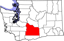 | |
| Towns | ||
| CDPs | ||
| Other unincorporated communities | ||
| Indian reservation | ||
| Footnotes | ‡This populated place also has portions in an adjacent county or counties | |
