Lincoln County, Washington
| Lincoln County, Washington | |
|---|---|
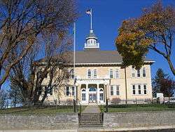 Lincoln County Courthouse | |
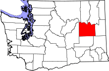 Location in the U.S. state of Washington | |
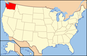 Washington's location in the U.S. | |
| Founded | 24 November, 1883 |
| Named for | Abraham Lincoln |
| Seat | Davenport |
| Largest city | Davenport |
| Area | |
| • Total | 2,339 sq mi (6,058 km2) |
| • Land | 2,310 sq mi (5,983 km2) |
| • Water | 29 sq mi (75 km2), 1.2% |
| Population (est.) | |
| • (2017) | 10,579 |
| • Density | 4.4/sq mi (1.7/km2) |
| Congressional district | 5th |
| Time zone | Pacific: UTC−8/−7 |
| Website |
www |
Lincoln County is a county located in the U.S. state of Washington. As of the 2010 census, the population was 10,570,[1] making it the fifth-least populous county in Washington.[2] The county seat and largest city is Davenport.[3] The county was created out of Whitman County in November 1883[4] and is named for Abraham Lincoln, 16th President of the United States.[5]
History
In 1883, Lincoln County was created from a portion of Spokane County, and four days later a portion of its area was peeled off to create Douglas County. There have been no further alterations to its boundary since that time.[6]. Its 2,317 square miles make it #8 in size in the state.
Centuries ago, the area now covered by Lincoln County contained an east-west passageway used by indigenous peoples. A spring near the present-day Davenport created a large overnight camping place.
The early exploration of the Northwest Territory by Lewis and Clark did not reach as far north as the Lincoln County expanses. The first recorded entry by European explorers was of David Thompson, a scout for the North West Company, who traversed the area in 1811. He noted physical locations in present-day Lincoln County. He described Hell Gate Rapid (calling it 'Strong Rapid'). That stretch of the Columbia River is now tame, because of the presence of Grand Coulee Dam.[6] After this, there was considerable exploration by fur trappers and others, including famed Scotch botanist David Douglas in 1826.[6]
Possibly the first permanent non-indigenous resident of the area was R.M. Bacon, originally from Boston, who began raising cattle around Crab Creek in 1871. When the first post office was established in the county, Bacon was its postmaster.[6]
Emigration into the area accelerated in the late 1870s. Completion of the Northern Pacific Railway in 1883, and construction of Fort Spokane (1880-1882) hastened settlement.
Geography and climate
Lincoln County lies on the channelled Scablands, known as the Big Bend Plateau. It lies 1,500-2,500 feet above sea level, with a system of channels eroded into bedrock by glacial rivers and streams, flowing from northeastern Washington.
Lincoln County climate is hot/dry in the summer, cold/moderately humid in the winter. Due to the relatively level terrain (about 1,200 feet difference from lowest to highest elevations), temperatures tend to vary little from east to west. Precipitation varies from an arid condition in the western part of the county to semi-arid in the northeast. The entire area lies in the dry intermontane basin between the Cascades and the Rocky Mountain System. Precipitation (10-20 inches annual rainfall) is a major controlling factor in agriculture. Precipitation in the Big Bend region is highly variable; from 8 inches in the west to 20 inches in the northeast.
Monthly temperature averages range from below freezing in mid-winter to high of 65-71°F in mid-summer.[6]
According to the U.S. Census Bureau, the county has a total area of 2,339 square miles (6,060 km2), of which 2,310 square miles (6,000 km2) is land and 29 square miles (75 km2) (1.2%) is water.[7]
Geographic features
- Columbia River
- Lilienthal Mountain, county high point
Major highways
Adjacent counties
- Ferry County – north
- Stevens County – northeast
- Spokane County – east
- Whitman County – southeast
- Adams County – south
- Grant County – west
- Okanogan County – northwest
National protected area
Demographics
| Historical population | |||
|---|---|---|---|
| Census | Pop. | %± | |
| 1890 | 9,312 | — | |
| 1900 | 11,969 | 28.5% | |
| 1910 | 17,539 | 46.5% | |
| 1920 | 15,141 | −13.7% | |
| 1930 | 11,876 | −21.6% | |
| 1940 | 11,361 | −4.3% | |
| 1950 | 10,970 | −3.4% | |
| 1960 | 10,919 | −0.5% | |
| 1970 | 9,572 | −12.3% | |
| 1980 | 9,604 | 0.3% | |
| 1990 | 8,864 | −7.7% | |
| 2000 | 10,184 | 14.9% | |
| 2010 | 10,570 | 3.8% | |
| Est. 2017 | 10,579 | [8] | 0.1% |
| U.S. Decennial Census[9] 1790–1960[10] 1900–1990[11] 1990–2000[12] 2010–2016[1] | |||
2000 census
As of the census[13] of 2000, there were 10,184 people, 4,151 households, and 2,914 families in the county. The population density was 4 people per square mile (2/km²). There were 5,298 housing units at an average density of 2 per square mile (1/km²). The racial makeup of the county was 95.64% White, 0.23% Black or African American, 1.63% Native American, 0.25% Asian, 0.07% Pacific Islander, 0.58% from other races, and 1.61% from two or more races. 1.88% of the population were Hispanic or Latino of any race. 36.6% were of German, 10.5% English, 9.3% United States or American and 5.8% Irish ancestry.
There were 4,151 households out of which 29.30% had children under the age of 18 living with them, 60.90% were married couples living together, 6.40% had a female householder with no husband present, and 29.80% were non-families. 26.00% of all households were made up of individuals and 12.30% had someone living alone who was 65 years of age or older. The average household size was 2.42 and the average family size was 2.91.
In the county, the population was spread out with 25.30% under the age of 18, 5.20% from 18 to 24, 23.20% from 25 to 44, 27.40% from 45 to 64, and 19.00% who were 65 years of age or older. The median age was 43 years. For every 100 females there were 98.40 males. For every 100 females age 18 and over, there were 94.70 males.
The median income for a household in the county was $35,255, and the median income for a family was $41,269. Males had a median income of $31,086 versus $22,444 for females. The per capita income for the county was $17,888. About 8.40% of families and 12.60% of the population were below the poverty line, including 17.60% of those under age 18 and 7.70% of those age 65 or over.
2010 census
As of the 2010 United States Census, there were 10,570 people, 4,422 households, and 3,059 families residing in the county.[14] The population density was 4.6 inhabitants per square mile (1.8/km2). There were 5,776 housing units at an average density of 2.5 per square mile (0.97/km2).[15] The racial makeup of the county was 95.0% white, 1.6% American Indian, 0.4% Asian, 0.3% black or African American, 0.5% from other races, and 2.2% from two or more races. Those of Hispanic or Latino origin made up 2.3% of the population.[14] In terms of ancestry, 42.3% were German, 14.6% were Irish, 13.9% were English, 5.5% were Norwegian, 5.3% were Scotch-Irish, and 3.6% were American.[16]
Of the 4,422 households, 25.9% had children under the age of 18 living with them, 57.3% were married couples living together, 7.7% had a female householder with no husband present, 30.8% were non-families, and 27.1% of all households were made up of individuals. The average household size was 2.37 and the average family size was 2.85. The median age was 47.6 years.[14]
The median income for a household in the county was $45,582 and the median income for a family was $52,083. Males had a median income of $44,491 versus $30,617 for females. The per capita income for the county was $24,757. About 7.1% of families and 12.1% of the population were below the poverty line, including 21.5% of those under age 18 and 6.0% of those age 65 or over.[17]
Government and politics
The county is administered by a three-member Board of Commissioners.
Like neighbouring Adams County, Lincoln County is one of the most conservative counties in Washington; the last Democrat to win a majority in the county was Harry Truman in 1948. In 1964 it was one of only three counties in the state to be carried by Barry Goldwater, and was the nation's northernmost county or equivalent to vote for Goldwater.[18] In the last seven elections no Democratic candidate for President has received more than 36 percent of the county's vote. In 2016 Donald Trump carried the county with over 70 percent of the vote;[19] in 2012 Mitt Romney carried the county with 68.7 percent,[20] and in 2008 John McCain won the county with 63.3 percent of votes.[21]
In the 2008 elections, Republicans carried the county in all races where party affiliation was listed. In many cases they did so with over 65 percent of the vote. Hence Dino Rossi received 65 percent to Governor Christine Gregoire's 35 percent; Representative Cathy McMorris Rodgers received 78.1% of the county's vote; Sam Reed received 74.64% for Washington state Secretary of State; and Rob McKenna received 75.43% for Attorney General.[22]
| Year | Republican | Democratic | Third parties |
|---|---|---|---|
| 2016 | 70.1% 4,108 | 21.2% 1,244 | 8.7% 509 |
| 2012 | 68.7% 4,063 | 28.3% 1,673 | 3.0% 175 |
| 2008 | 63.3% 3,803 | 33.8% 2,032 | 2.9% 173 |
| 2004 | 69.1% 4,015 | 29.4% 1,706 | 1.6% 90 |
| 2000 | 68.2% 3,546 | 27.3% 1,417 | 4.5% 234 |
| 1996 | 51.4% 2,587 | 35.9% 1,806 | 12.7% 640 |
| 1992 | 43.6% 2,152 | 33.5% 1,653 | 22.9% 1,132 |
| 1988 | 57.9% 2,689 | 40.6% 1,884 | 1.6% 72 |
| 1984 | 66.9% 3,474 | 32.2% 1,671 | 0.9% 48 |
| 1980 | 62.3% 3,324 | 29.9% 1,597 | 7.8% 416 |
| 1976 | 57.6% 2,925 | 38.9% 1,978 | 3.5% 178 |
| 1972 | 69.1% 3,647 | 27.6% 1,453 | 3.3% 175 |
| 1968 | 59.3% 2,994 | 34.1% 1,721 | 6.7% 338 |
| 1964 | 55.8% 2,911 | 44.1% 2,299 | 0.1% 3 |
| 1960 | 58.8% 3,211 | 41.1% 2,248 | 0.1% 5 |
| 1956 | 57.8% 3,114 | 42.2% 2,273 | 0.1% 3 |
| 1952 | 63.3% 3,422 | 36.5% 1,974 | 0.2% 9 |
| 1948 | 47.7% 2,348 | 51.1% 2,518 | 1.2% 58 |
| 1944 | 53.8% 2,723 | 46.0% 2,328 | 0.3% 15 |
| 1940 | 47.3% 2,627 | 52.2% 2,896 | 0.5% 29 |
| 1936 | 26.1% 1,325 | 71.6% 3,627 | 2.3% 117 |
| 1932 | 38.0% 1,748 | 59.3% 2,725 | 2.7% 122 |
| 1928 | 59.6% 2,718 | 39.6% 1,807 | 0.8% 34 |
| 1924 | 46.2% 2,042 | 16.8% 743 | 37.1% 1,639 |
| 1920 | 65.0% 3,038 | 29.9% 1,395 | 5.1% 238 |
| 1916 | 43.1% 2,356 | 51.7% 2,827 | 5.3% 288 |
| 1912 | 14.5% 691 | 38.3% 1,829 | 47.3% 2,260 |
| 1908 | 55.2% 2,025 | 39.3% 1,443 | 5.5% 201 |
| 1904 | 67.4% 2,472 | 27.4% 1,004 | 5.2% 191 |
| 1900 | 45.6% 1,414 | 51.1% 1,585 | 3.3% 103 |
| 1896 | 30.2% 781 | 68.4% 1,771 | 1.4% 36 |
| 1892 | 39.2% 915 | 35.6% 831 | 25.2% 589 |
Economy
The county is dependent on agriculture, primarily wheat farming. Lincoln County is generally considered the second-largest producer of wheat in the United States (following Whitman County, Washington), sometimes producing 25 million bushels (680,000 t) per year.[24] Only about 500,000 of 900,000 acres (2,000 of 3,600 km2 (1,390 sq mi)) of farmland in the county are planted in any given year due to the practice of typically harvesting one crop every two years ("summer-fallow"), a necessity in a region with only 12 inches (300 mm) of precipitation annually.
Livestock husbandry is also a significant county activity, although to a significantly lower degree. For example, in 1954 the county was #3 in the state for crop income, but was only #21 in the state for income from livestock and livestock products.[6] Raising beef Raising beef cattle is the major type of livestock farming.
Communities
Cities
- Davenport (county seat)
- Harrington
- Sprague
Towns
Unincorporated communities
Ghost towns
See also
Further reading
- An illustrated history of the Big Bend country : embracing Lincoln, Douglas, Adams, and Franklin counties, state of Washington. Western Historical Pub. Co. 1904. Available online through the Washington State Library's Classics in Washington History collection
References
- 1 2 "State & County QuickFacts". United States Census Bureau. Archived from the original on 14 July 2011. Retrieved 7 January 2014.
- ↑ Ahead of Ferry County (7,551), Columbia County (4,078), Wahkiakum County (3,978), and Garfield County (2,266).
- ↑ "Find a County". National Association of Counties. Retrieved 7 June 2011.
- ↑ "Milestones for Washington State History — Part 2: 1851 to 1900". HistoryLink.org. 6 March 2003.
- ↑ Gannett, Henry (1905). The Origin of Certain Place Names in the United States. U.S. Government Printing Office. p. 187.
- 1 2 3 4 5 6 Lincoln County History
- ↑ "2010 Census Gazetteer Files". United States Census Bureau. 22 August 2012. Retrieved 7 July 2015.
- ↑ "Population and Housing Unit Estimates". Retrieved 4 April 2018.
- ↑ "U.S. Decennial Census". United States Census Bureau. Retrieved 7 January 2014.
- ↑ "Historical Census Browser". University of Virginia Library. Retrieved 7 January 2014.
- ↑ "Population of Counties by Decennial Census: 1900 to 1990". United States Census Bureau. Retrieved 7 January 2014.
- ↑ "Census 2000 PHC-T-4. Ranking Tables for Counties: 1990 and 2000" (PDF). United States Census Bureau. Retrieved 7 January 2014.
- ↑ "American FactFinder". United States Census Bureau. Retrieved 14 May 2011.
- 1 2 3 "DP-1 Profile of General Population and Housing Characteristics: 2010 Demographic Profile Data". United States Census Bureau. Retrieved 6 March 2016.
- ↑ "Population, Housing Units, Area, and Density: 2010 – County". United States Census Bureau. Retrieved 6 March 2016.
- ↑ "Selected Social Characteristics in the United States – 2006–2010 American Community Survey 5-Year Estimates". United States Census Bureau. Retrieved 6 March 2016.
- ↑ "Selected Economic Characteristics - 2006–2010 American Community Survey 5-Year Estimates". United States Census Bureau. Retrieved 6 March 2016.
- ↑ David Leip's Presidential Atlas Map for Washington by election
- ↑ David Leip's Presidential Atlas Map for Washington, 2016
- ↑ David Leip's Presidential Atlas Map for Washington, 2012
- ↑ David Leip's Presidential Atlas Map for Washington, 2008
- ↑ Washington Government site on election results for Lincoln County Archived 10 May 2009 at the Wayback Machine.
- ↑ Leip, David. "Dave Leip's Atlas of U.S. Presidential Elections". uselectionatlas.org. Retrieved 10 April 2018.
- ↑ United States Dept. of Agriculture
Places adjacent to Lincoln County, Washington | ||||||||||
|---|---|---|---|---|---|---|---|---|---|---|
| ||||||||||
Municipalities and communities of Lincoln County, Washington, United States | ||
|---|---|---|
| Cities | | |
| Towns | ||
| Unincorporated communities | ||
| Ghost town | ||
