Quillehuyte County
Quillehuyte County was one of the Washington Territory's counties from January 29, 1868 until 1869.[1] It and Ferguson County[2] are the only two counties of the territory (now the State of Washington) to have become extinct, although the Washington Territorial Legislature attempted to dissolve Skamania County in January, 1865 but was overruled by the United States Congress.[3] Additionally, some Washington counties have been renamed since their formation; Sawamish County (from a Salish people's name) was renamed to Mason in 1864 for example.[3]
The county was probably named for the Quileute people, also taken for the Quillayute River, airport, etc. with varying spellings due to transliteration of their name from the Chimakuan language. Creation of the county from the western half of Jefferson and a portion of Clallam county (also formed from Jefferson County in 1854) may have been intended to strengthen non-Native land claims and to encourage the indigenous Quileute people to vacate to newly established (1855) Quinault reservation.[4]
Because it was never organized,[4] it is impossible to say what the county seat was intended to be. The largest populated place in the former county is Forks, population c. 3,532 in 2010.[5]
Boundaries
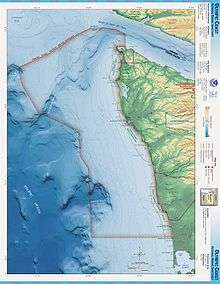
Boundaries were set forth by the Territorial Legislature as follows: from the mouth of Wyatch River (modern spelling Waatch) on Makah Bay (48°20′37″N 124°40′31″W / 48.3437°N 124.6752°W), southeast through Olympic Mountains "along the summit" to 48°N 124°W / 48°N 124°W, south to Chehalis County boundary (now Grays Harbor County) (47°31′04″N 124°00′00″W / 47.5178°N 124°W), west along Chehalis County boundary to Pacific coast at Queets (47°32′00″N 124°21′16″W / 47.5334°N 124.3545°W), north along Pacific coast to origin.[6]
References
- ↑ Smith 1913, p. 11.
- ↑ Paula Becker (September 20, 2005), Ferguson County is established on January 23, 1863, HistoryLink
- 1 2 Smith 1913, p. 5.
- 1 2 Kit Oldham (December 27, 2005), Clallam County — Thumbnail History, HistoryLink
- ↑ United States Census Bureau. "Census of Population and Housing". Archived from the original on May 12, 2015. Retrieved July 21, 2014.
- ↑ Laws of Washington 1896, p. 438.
Sources
- Smith, C.W. (1913). The Naming of Counties in the State of Washington. Bulletin of the University of Washington: University studies. University of Washington. Retrieved 2018-03-14.
- Laws of Washington: A Publication of the Session Laws of Washington Territory, Including the General Laws and Resolutions of the Years 1854 to 1888 Inclusive. The Federal and Colonial Orders, Treaties, Acts and Ordinances Affecting Land Titles in Washington. From the Original Rolls. Laws of Washington: A Publication of the Session Laws of Washington Territory, Including the General Laws and Resolutions of the Years 1854 to 1888 Inclusive. The Federal and Colonial Orders, Treaties, Acts and Ordinances Affecting Land Titles in Washington. From the Original Rolls. Tribune Prtg. Company. 1896. Retrieved 2018-03-14.