Bellevue, Washington
| Bellevue, Washington | ||
|---|---|---|
| City | ||
| City of Bellevue | ||
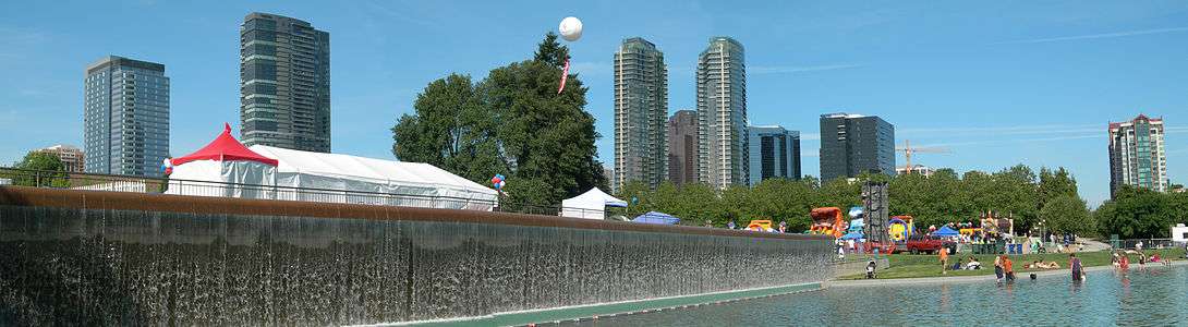
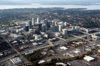 Downtown Bellevue seen in 2011 against the backdrop of Lake Washington | ||
| ||
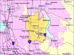
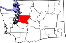
 Location of Bellevue within King County, Washington, and King County within Washington. | ||
 U.S. Census Map | ||
 Bellevue, Washington Location in the United States | ||
| Coordinates: 47°36′N 122°10′W / 47.600°N 122.167°WCoordinates: 47°36′N 122°10′W / 47.600°N 122.167°W | ||
| Country | United States | |
| State | Washington | |
| County | King | |
| Incorporated | March 21, 1953 | |
| Government | ||
| • Mayor | John Chelminiak | |
| Area[1] | ||
| • City | 36.47 sq mi (94.46 km2) | |
| • Land | 31.97 sq mi (82.80 km2) | |
| • Water | 4.50 sq mi (11.65 km2) | |
| Elevation | 85 ft (26 m) | |
| Population (2010)[2] | ||
| • City | 122,363 | |
| • Estimate (2017) | 144,444 | |
| • Rank | US: 186th | |
| • Density | 3,827.4/sq mi (1,477.8/km2) | |
| • Metro | 3,733,580 (US: 15th) | |
| Time zone | UTC−8 (PST) | |
| • Summer (DST) | UTC−7 (PDT) | |
| ZIP Codes | 98004-98009 | |
| Area code | 425 | |
| FIPS code | 53-05210 | |
| GNIS ID | 1512000[3] | |
| Website | www.bellevuewa.gov | |

Bellevue (/ˈbɛlvjuː/ BEL-vyoo) is a city in the Eastside region of King County, Washington, United States, across Lake Washington from Seattle. As the third-largest city in the Seattle metropolitan area, Bellevue has variously been characterized as an edge city, a suburb, boomburb, or satellite city.[4][5] Its population was 144,444 in a 2017 census estimate.
Prior to 2008, downtown Bellevue underwent rapid change, with many high rise projects under construction, and was relatively unaffected by the economic downturn. The downtown area is currently the second largest city center in Washington state with 1,300 businesses, 45,000 employees and 10,200 residents.[6] Based on per capita income, Bellevue is the 6th wealthiest of 522 communities in the state of Washington.[7] In 2008, Bellevue was named number 1 in CNNMoney's list of the best places to live and launch a business,[8] and in 2010 was again ranked as the 4th best place to live in America.[9] In 2014, Bellevue was ranked as the 2nd best place to live by USA Today.[10] More than 145 companies have been located in Bellevue. Current companies with headquarters in Bellevue include Expedia, T-Mobile and Valve Corporation.
The name "Bellevue" is derived from the French words for "beautiful view".[11]
History
Bellevue was settled in 1869 by William Meydenbauer and Aaron Mercer, who claimed homestead tracts several miles apart. Prior to the opening of the Lake Washington Floating Bridge in 1940, Bellevue was a rural area with little development. Although it was small, developers were pushing to change that; in the 1920s, James S. Ditty predicted that it would become a city with a population of 200,000.[12] He envisioned plans that included the bridging of Lake Washington and an area filled with golf courses and airports.[13] His map with these visions was published in 1928.[13]
Once the Murrow Memorial Bridge opened, access from Seattle improved, and the area gradually grew into a bedroom community.[11] After the Japanese Internment began in 1942 a large quantity of farm land was available for development.[14] This made way for the initial development of the Bellevue downtown area.
Bellevue incorporated a third class city on the March 21, 1953. Following the 1963 opening of a second bridge across the lake, the Evergreen Point Floating Bridge, the city began to grow more rapidly. It has since become one of the largest cities in the state, with several high-rise structures in its core and a burgeoning business community. The city experienced a building boom during the mid 2000s, with the building of developments such as Lincoln Square and the Bravern.[11]
Reflective of Bellevue's growth over the years is Bellevue Square, now one of the largest shopping centers in the region. Opened in 1946,[11] the mall underwent a significant expansion in the 1980s. More recently, an expansion along Bellevue Way called "The Lodge" and the new One Lincoln Tower promise to strengthen downtown Bellevue's role as the largest Seattle Eastside shopping and dining destination.
The city's long-term plans include the Bel-Red Corridor Project, a large-scale planning effort to encourage the redevelopment of a large northern section of the city bordering the adjacent town of Redmond which is a major employment area in the city.[15] Patterned after what many civic leaders consider the successful redevelopment of the downtown core, early plans include "superblock" mixed use projects similar to Lincoln Square. Premised on the 2008 approval of the extension of Link Light Rail to the Eastside, the city hopes to mitigate transportation problems impeding earlier efforts in redeveloping the downtown core; viewed as an economic development opportunity by many in the business and building development community, the process has focused on infrastructure and the encouragement of private construction in a large-scale urban renewal effort.
Geography
Bellevue is located at 47°36′N 122°12′W / 47.6°N 122.2°W (47.5976, −122.1592).[16]
According to the United States Census Bureau, the city has a total area of 36.47 square miles (94.46 km2), of which, 31.97 square miles (82.80 km2) is land and 4.50 square miles (11.65 km2) is water.[1]
The city's name is derived from a French term for "beautiful view". Under favorable weather conditions, scenic vistas of the Olympic Mountains and Cascade Mountains can be viewed from hilltops (and strategically positioned high-rise buildings) within the incorporated city.
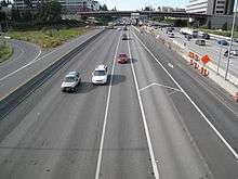
The city lies between Lake Washington to the west and the smaller Lake Sammamish to the east. Much of Bellevue is drained by the Kelsey Creek watershed, whose source is located in the Larsen and Phantom Lake green belt and whose outlet is near where Interstate 90 meets Lake Washington's eastern shore. The city is bisected by Interstate 405 running north-south, and the southern portion is crossed from west to east by Interstate 90. The State Route 520 freeway roughly delineates the upper reaches of Bellevue.
South of I-90, the city continues up Cougar Mountain, at the top of which lies is an unincorporated King County location called Hilltop. To the west of Cougar Mountain, Bellevue includes the Coal Creek, Somerset, and Factoria neighborhoods.
Bellevue is bordered by the cities of Kirkland to the north and Redmond to the northeast along the Overlake and Crossroads neighborhoods. Across the short East Channel Bridge, I-90 connects Bellevue to Mercer Island to the southwest. Issaquah is to the east, down I-90 at the south end of Lake Sammamish. The city is also bordered to the west by many affluent suburbs such as Medina, Clyde Hill, Hunts Point and Yarrow Point. The south end of Bellevue is bordered by the city of Renton, and to the southeast, the relatively recently incorporated city of Newcastle.
Cityscape
Communities within Bellevue include Bellecrest, Bridle Trails, Crossroads, Eastgate/Cougar Mountain, Enatai, Factoria, Newport, Northeast Bellevue, Northwest Bellevue, Sammamish/East Bellevue, Somerset, Sunset, Tam o'shanter, West Bellevue, West Lake Hills, Wilburton, and Woodridge.[17]
 Bellevue, Washington aerial with Seattle seen across Lake Washington, 2013
 Skyline from Lake Washington, 2015
Climate
Like much of the Puget Sound lowland, Bellevue has a mild oceanic climate. It also has frequent rain showers from October to May, with precipitation levels typically being over 2 inches.[18] On average, the hottest month is July, while January is the coldest.[18]
| Bellevue | ||||||||||||||||||||||||||||||||||||||||||||||||||||||||||||
|---|---|---|---|---|---|---|---|---|---|---|---|---|---|---|---|---|---|---|---|---|---|---|---|---|---|---|---|---|---|---|---|---|---|---|---|---|---|---|---|---|---|---|---|---|---|---|---|---|---|---|---|---|---|---|---|---|---|---|---|---|
| Climate chart (explanation) | ||||||||||||||||||||||||||||||||||||||||||||||||||||||||||||
| ||||||||||||||||||||||||||||||||||||||||||||||||||||||||||||
| ||||||||||||||||||||||||||||||||||||||||||||||||||||||||||||
| Climate data for Bellevue, Washington | |||||||||||||
|---|---|---|---|---|---|---|---|---|---|---|---|---|---|
| Month | Jan | Feb | Mar | Apr | May | Jun | Jul | Aug | Sep | Oct | Nov | Dec | Year |
| Record high °F (°C) | 65 (18) |
70 (21) |
78 (26) |
89 (32) |
93 (34) |
98 (37) |
105 (41) |
100 (38) |
100 (38) |
90 (32) |
75 (24) |
64 (18) |
105 (41) |
| Average high °F (°C) | 43 (6) |
47 (8) |
54 (12) |
58 (14) |
66 (19) |
70 (21) |
77 (25) |
78 (26) |
71 (22) |
60 (16) |
51 (11) |
44 (7) |
60 (16) |
| Average low °F (°C) | 32 (0) |
35 (2) |
38 (3) |
42 (6) |
47 (8) |
52 (11) |
55 (13) |
57 (14) |
52 (11) |
46 (8) |
40 (4) |
34 (1) |
44 (7) |
| Record low °F (°C) | −5 (−21) |
−4 (−20) |
10 (−12) |
27 (−3) |
28 (−2) |
36 (2) |
42 (6) |
42 (6) |
35 (2) |
21 (−6) |
4 (−16) |
0 (−18) |
−5 (−21) |
| Average precipitation inches (mm) | 4.49 (114) |
3.67 (93.2) |
3.84 (97.5) |
2.84 (72.1) |
2.10 (53.3) |
1.68 (42.7) |
0.97 (24.6) |
0.97 (24.6) |
1.71 (43.4) |
3.32 (84.3) |
4.92 (125) |
5.45 (138.4) |
35.96 (913.4) |
| Source #1: [19] | |||||||||||||
| Source #2: [20] | |||||||||||||
Surrounding cities
Transportation
Bellevue is the main Eastside hub for both the local transit authority, King County Metro, and Sound Transit, the regional transit system. The Bellevue Transit Center, which serves both Metro and Sound buses, is located in the heart of the downtown business district and is connected to Interstate 405 by NE 6th St. and a direct-access Texas T HOV ramp. Local buses run into Kirkland, Redmond, Issaquah, Renton, and the University District;[21] regional buses go to Bothell, Lynnwood, Everett, Seattle, Renton, Kent and Auburn, among other cities.[22]
The East Link light rail line is planned to run from Seattle through Mercer Island and Bellevue before ending in Redmond. It was approved by voters on November 4, 2008, as part of the Sound Transit 2 ballot measure.[23] It began construction in 2015 and is scheduled to begin service in 2023.
The Bellevue City Council lobbied hard for Sound Transit—a regional transit authority—to construct its light-rail line underground through Bellevue's rapidly growing downtown.[24] Bellevue promised to devote between $104 million to $150 million toward a potential tunnel in the form of cash, services, free access to rights-of-way and one-time tax revenues that result from the East Link project. In November 2011, the council signed an agreement with Sound Transit.[25] Tunnel construction started in early 2016 while the remainder of downtown Bellevue construction began in mid-2017.[26] Former Bellevue City Council member Claudia Balducci is a member of the Sound Transit board of directors.
The City of Bellevue has undertaken an extensive "Bel-Red Area Transformation" process which seeks to plan some 900 acres (3.6 km2) in the Spring District in the city's northern portion,[27] all of which is premised on the extension of light rail to the Eastside under Sound Transit 2.[28] The top-down and highly integrated land use and transportation planning is similar to earlier planning for the Downtown.
Bellevue was also served by a railroad, a Burlington Northern branch line known as the Woodinville Subdivision, which included the historic Wilburton Trestle. This local freight line was the subject of debate over whether to railbank the line and construct a multi-purpose trail. As of March 2009, the Port of Seattle had to postpone its acquisition of the corridor because of instability in the bond market. As of 2016 the line is disused however part of the track bed at Wilburton Station will be reused by Sound Transit's light-rail construction.[29]
The city once had an operating airfield named Bellevue Airfield.
Government and politics

| Year | Republican | Democratic | Third Parties |
|---|---|---|---|
| 2016 | 24.58% 15,175 | 66.11% 40,820 | 9.31% 5,747 |
| 2012 | 35.76% 22,083 | 61.59% 38,036 | 2.65% 1,634 |
| 2008 | 34.41% 19,531 | 63.82% 36,224 | 1.77% 1,004 |
| 2004 | 41.68% 24,089 | 57.01% 32,952 | 1.31% 756 |
Bellevue has a council-manager form of government with seven non-partisan council members elected at large for staggered four-year terms.[31] The City Council selects a Mayor from among its members (and not by popular vote), who serves as council chair but has no veto power. As of 2018, the Mayor is John Chelminiak and the Deputy Mayor is Lynne Robinson.[32]
The mayor administrates council meetings, helps set the issues on the council's meeting agendas, and serves as the city's most visible spokesperson, while operational authority is held by the city manager, who operates the city's day-to-day activities. The city manager is also elected by the seven members of the council and not by popular vote.
Bellevue is a left-leaning city. Of the 61,742 residents who cast ballots in the 2016 U.S. presidential election, 66.11% voted for Hillary Clinton compared to 24.58% for Donald Trump.[33]
Education
Bellevue is home to Bellevue College (BC) and City University of Seattle.
The city hosts the Bellevue School District. There are four main public high schools – Bellevue High School, Interlake High School, Newport High School, and Sammamish High School – as well as two alternative high schools, International School and Big Picture School (formerly known as Robinswood Alternative High School), which reopened in 2011. Newsweek's 2015 ranking of U.S. public high schools placed Interlake at #359 and Newport at #391, with both schools noted for equitably helping low-income students meet average scores on standardized tests.[34] Portions of Bellevue also lie within the boundaries of Lake Washington School District, Renton School District and Issaquah School District.
Bellevue is home to Open Window School, an independent school serving gifted students in kindergarten through eight grade. The Jewish Day School of Metropolitan Seattle is located in Bellevue, serving students from Pre-Kindergarten to Grade 8.
At the elementary level, Bellevue is home to several Montessori schools, the Eastside's only Waldorf education at Three Cedars School, as well as Bellevue Christian School.
The Seattle Japanese School, a Japanese weekend supplementary school, holds its classes in Bellevue.[35]
Economy
Bellevue is home to the headquarters of many small and large businesses, including many technology companies started in the 1990s, such as celebrated video game companies Valve and Bungie. Bellevue neighbors Redmond, home of Microsoft and Nintendo of America, and has direct highway access to Seattle via Interstate 90 and State Route 520. The city has numerous thriving commercial districts, including three major shopping centers aside from Bellevue Square: Factoria Mall to the south, Crossroads Mall to the east, and the Overlake Shopping District in the north.
Demographics
| Historical population | |||
|---|---|---|---|
| Census | Pop. | %± | |
| 1900 | 254 | — | |
| 1910 | 150 | −40.9% | |
| 1920 | 1,213 | 708.7% | |
| 1930 | 1,071 | −11.7% | |
| 1940 | 1,177 | 9.9% | |
| 1950 | 7,658 | 550.6% | |
| 1960 | 12,809 | 67.3% | |
| 1970 | 61,196 | 377.8% | |
| 1980 | 73,903 | 20.8% | |
| 1990 | 86,874 | 17.6% | |
| 2000 | 109,569 | 26.1% | |
| 2010 | 122,363 | 11.7% | |
| Est. 2017 | 144,444 | 18.0% | |
| source:[36] 2017 Estimate[38] | |||
According to a 2012 estimate, the median income for a household in the city was $88,073, and the median income for a family was $104,839. The per capita income for the city was $48,719.
In 2006, Bellevue was rated one of the 25 safest cities in America,[39] based on the per-capita incidence of violent crime.
2010 census
As of the census[2] of 2010, there were 122,363 people, 50,355 households, and 32,145 families residing in the city. The population density was 3,827.4 inhabitants per square mile (1,477.8/km2). There were 55,551 housing units at an average density of 1,737.6 per square mile (670.9/km2). The racial makeup of the city was 62.6% White, 2.2% African American, 0.4% Native American, 27.6% Asian, 0.2% Pacific Islander, 3.1% from other races, and 3.9% from two or more races. Hispanic or Latino of any race were 7.0% of the population.
There were 50,355 households of which 30.0% had children under the age of 18 living with them, 52.9% were married couples living together, 7.6% had a female householder with no husband present, 3.3% had a male householder with no wife present, and 36.2% were non-families. 28.1% of all households were made up of individuals and 8.4% had someone living alone who was 65 years of age or older. The average household size was 2.41 and the average family size was 2.97.
The median age in the city was 38.5 years. 21.2% of residents were under the age of 18; 7.6% were between the ages of 18 and 24; 30.8% were from 25 to 44; 26.5% were from 45 to 64; and 13.9% were 65 years of age or older. The gender makeup of the city was 50.1% male and 49.9% female.
2000 census
As of the census of 2000, there were 109,569 people, 45,836 households, and 29,060 families residing in the city. The population density was 3,563.6 inhabitants per square mile (1,375.8/km²). There were 48,396 housing units at an average density of 607.7/km² (1,574.0/mi²). The racial makeup of the city was 74.33% White, 1.99% African American, 0.32% Native American, 17.39% Asian, 0.23% Pacific Islander, 2.54% from other races, and 3.19% from two or more races. Hispanic or Latino of any race were 5.32% of the population.
There were 45,836 households out of which 27.5% had children under the age of 18 living with them, 53.0% were married couples living together, 7.5% had a female householder with no husband present, and 36.6% were non-families. 28.4% of all households were made up of individuals and 7.9% had someone living alone who was 65 years of age or older. The average household size was 2.37 and the average family size was 2.93.
In the city, the population was spread out with 21.1% under the age of 18, 7.8% from 18 to 24, 32.6% from 25 to 44, 25.0% from 45 to 64, and 13.4% who were 65 years of age or older. The median age was 38 years. For every 100 females, there were 98.4 males. For every 100 females age 18 and over, there were 96.6 males.
The median income for a household in the city was $62,338, and the median income for a family was $76,868. Males had a median income of $56,456 versus $37,124 for females. The per capita income for the city was $36,905. About 3.8% of families and 5.7% of the population were below the poverty line, including 5.7% of those under age 18 and 6.3% of those age 65 or over.
Culture
Recurring cultural events
Bellevue is the site of the popular annual Bellevue Arts and Crafts Fair (originally Pacific Northwest Arts and Crafts Fair), held since 1947 the last weekend in July. The biennial Bellevue Sculpture Exhibition draws thousands of visitors to the Downtown Park to view up to 46 three-dimensional artworks from artists around the country. In celebration of its strawberry farming history, Bellevue holds an annual Strawberry Festival on the fourth weekend in June.[40] The festival initially began in 1925, and continued to 1942 when many Bellevue's strawberry farmers were incarcerated as part of the Japanese Internment. In 1987 the festival was resumed as a one evening event, and in 2003 it was expanded back to a multi-day festival.[41]
Places of interest

The Bellevue Arts Museum first opened in 1975, then moved to Bellevue Square in 1983. In 2001, the museum moved into its own building, designed by Steven Holl. The museum subsequently ran into financial difficulties and was forced to close to the public in 2003. After a lengthy fundraising campaign, a remodel, and a new mission to become a national center for the fine art of craft and design, the museum reopened on June 18, 2005 with an exhibition of teapots.[42] The Rosalie Whyel Museum of Doll Art - now closed - contained one of the largest doll collections in the world—more than a thousand dolls—displayed on two floors of a Victorian-style building,[43] which is now the site of the KidsQuest Children's Museum. The museum's primary visitors are mothers and care givers with children from pre-crawlers to 12 years of age. Its 10,000-square-foot (930 m2) space houses play and discovery areas, exhibits, offices, educational activities and classroom space. Near Interstate 405 is Meydenbauer Center, a convention center that brings corporate meetings and charity events to the downtown area. Meydenbauer also includes a 410-seat theater which attracts operas, ballets, and orchestral performances.[44]
Sports and recreation
Since the 1970s, the city has taken an active role in ensuring that its commercial development does not overwhelm its natural land and water resources.[45] Today, the Bellevue Parks and Community Services Department manages more than 2,500 acres (10 km2) of parks and open spaces, including the Downtown Park and the Bellevue Botanical Garden, as well as several playgrounds, beach parks, and trails. More than 5,500 Bellevue residents participate in volunteer activities through this department annually.[46]
Bellevue was home to the American Basketball Association team, the Bellevue Blackhawks. The Blackhawks in 2005, despite being ranked 13th in the league, made it to the championship game in front of 15,000 fans in Little Rock, Arkansas.[47] The team has been inactive since 2006.[48]
Notable people
- William S. Ayer, former president and CEO of Alaska Airlines[49]
- Peter Horton, actor[50]
- James Love, Director, Knowledge Ecology International[51]
- Rob McKenna, former Attorney General of Washington[52]
- Satya Nadella, CEO of Microsoft[53]
- Timothy Omundson, actor[54]
- Larry Sanger, Wikipedia co-founder[55]
- Ann Wilson, co-founder of Heart[56]
- Nancy Wilson, co-founder of Heart[56]
- Ricky Horror, guitarist and backing vocalist of Motionless in White
- Gabe Newell, Owner Valve Corporation
Athletes, coaches, and sportscasters
- Tim Lincecum, MLB pitcher for San Francisco Giants, Los Angeles Angels of Anaheim
- John Olerud, MLB baseball player for Toronto Blue Jays, Seattle Mariners[57]
- Dave Niehaus, broadcaster for California Angels and Seattle Mariners, recipient of the Ford C. Frick Award[58]
- Chuck Swirsky, NBA broadcaster for Chicago Bulls, Toronto Raptors
- Matt Hague, professional baseball player, first baseman for Toronto Blue Jays
- Matthew Boyd, professional baseball player, pitcher for Detroit Tigers
- Robert Stock (born 1989), MLB baseball player, pitcher for San Diego Padres
- Russell Wilson, professional football player, quarterback for Seattle Seahawks [59]
Sister cities
Bellevue has the following sister cities:[60][61]
See also
References
- 1 2 "US Gazetteer files 2010". United States Census Bureau. Archived from the original on July 14, 2012. Retrieved December 19, 2012.
- 1 2 "American FactFinder". United States Census Bureau. Retrieved December 19, 2012.
- ↑ "Bellevue". Geographic Names Information System. United States Geological Survey.
- ↑ K. Hinton; A. Tijerino (June 22, 2001). ""Boomburbs": The Emergence of Large, Fast-Growing Suburban Cities in the United States" (PDF). Fannie Mae Foundation. Archived from the original (PDF) on June 14, 2007. Retrieved August 10, 2006.
- ↑ Danny Westneat (December 14, 2006). "Is Bellevue a "new Brooklyn?"". The Seattle Times. Archived from the original on February 11, 2007. Retrieved February 28, 2007.
- ↑ "Bellevue Downtown Association". 2011. Archived from the original on March 3, 2016. Retrieved May 6, 2016.
- ↑ "State & County QuickFacts — Bellevue, Washington". United States Census Bureau. Archived from the original on September 16, 2008. Retrieved July 18, 2008.
- ↑ "100 best places to live and launch". CNNMoney.com. July 2, 2008. Archived from the original on September 22, 2008. Retrieved September 24, 2008.
- ↑ "Best Places to Live". CNNMoney.com. Archived from the original on July 15, 2010. Retrieved July 16, 2010.
- ↑ Kent, Alexander; Allen, Ashley C.; Hess, Alexander E. M.; Serenbetz, Robert; Frohlich, Thomas (September 18, 2014). "America's 50 best cities to live in". USA Today. Retrieved September 20, 2014.
- 1 2 3 4 Stein, Alan J. (November 9, 1998). "Bellevue -- Thumbnail History". HistoryLink. Retrieved June 9, 2008.
- ↑ Welch, Bob. Bellevue and the New Eastside a Contemporary Portrait. Chatsworth: Windsor Publications, 1989. ISBN 0-89781-331-6.
- 1 2 Lutz, Brian. The Sledgehammer – Version 2.0 January 11, 2010 This Was the Future of Bellevue In 1928.
- ↑ Marsha, Alia. "How Bellevue businessmen who stoked fears benefited after Japanese American incarceration". The Seattle Gloabalist. Retrieved February 21, 2017.
- ↑ "Bel-Red Area Transformation". City of Bellevue. Archived from the original on November 30, 2016. Retrieved July 18, 2008.
- ↑ "US Gazetteer files: 2010, 2000, and 1990". United States Census Bureau. February 12, 2011. Retrieved April 23, 2011.
- ↑ "Bellevue Districts Map" (JPG). Ci.bellevevue.wa.us. Retrieved January 26, 2016.
- 1 2 "weather.com/weather/monthly/l/Bellevue+WA+98004:4:US". The Weather Channel. Retrieved October 7, 2016.
- ↑ "Average Weather for Bellevue, WA - Temperature and Precipitation". Weather.com. Retrieved September 6, 2010.
- ↑ "History for Seattle Boeing (Bellevue), WA". wunderground.com. Retrieved April 11, 2013.
- ↑ "Revised Boarding Locations at Bellevue Transit Center". September 16, 2008. Archived from the original on September 16, 2008. Retrieved January 26, 2017.
- ↑ "Archived copy". Archived from the original on June 17, 2011. Retrieved June 17, 2011.
- ↑ "Archived copy". Archived from the original on November 19, 2008. Retrieved November 19, 2008.
- ↑ Hicks, Joshua Adam (March 23, 2010). "Bellevue City Council unanimous on new downtown light-rail tunnel" Archived March 28, 2010, at the Wayback Machine.. Bellevue Reporter. Retrieved 2011-06-08.
- ↑ "East Link in Bellevue - Light Rail and Bellevue (Official City of Bellevue Website)". Archived from the original on February 1, 2017. Retrieved January 26, 2017.
- ↑ drupal.nichole (July 8, 2015). "Project updates: East Link Extension". Retrieved January 26, 2017.
- ↑ "Bel-Red Area Transformation - Bel-Red/Wilburton Area (Official City of Bellevue Website)". Ci.bellevue.wa.us. Archived from the original on November 30, 2016. Retrieved January 26, 2016.
- ↑ Archived February 5, 2016, at the Wayback Machine.
- ↑ stadmin (January 8, 2015). "Wilburton Station". Retrieved January 26, 2017.
- ↑ "King County Elections". www.kingcounty.gov. Retrieved 2018-03-23.
- ↑ "Washington City and Town Profiles". MRSC.org. Retrieved January 26, 2016.
- ↑ Dawson, Raechel (January 3, 2018). "Bellevue City Council elects John Chelminiak as mayor". Bellevue Reporter. Retrieved January 3, 2018.
- ↑ "2016 General - Election Results by precinct (complete eCanvass dataset) | King County | Open Data". King County. Retrieved 2018-03-23.
- ↑ "America's Top High Schools 2015". Newsweek. Retrieved January 26, 2016.
- ↑ "シアトル日本語補習学校 Seattle Japanese School | Home". Seajschool.org. Retrieved January 26, 2016.
- ↑ Moffatt, Riley. Population History of Western U.S. Cities & Towns, 1850−1990. Lanham: Scarecrow, 1996, 314.
- ↑ United States Census Bureau. "Census of Population and Housing". Archived from the original on May 12, 2015. Retrieved June 14, 2014.
- ↑ "City and Town Population Totals: 2010-2017". United States Census Bureau. Retrieved June 1, 2018.
- ↑ Christie, Les (October 30, 2006). "Most dangerous cities". CNNMoney.com. Archived from the original on July 19, 2008. Retrieved July 18, 2008.
- ↑ "Bellevue Strawberry Festival". 2008. Archived from the original on June 11, 2008. Retrieved June 7, 2008.
- ↑ Trescases, Heather. "Strawberry Festival Historical Sketch". Bellevue, WA Strawberry Festival. Retrieved February 22, 2017.
- ↑ Pastier, John (January 8, 2001). "Bellevue Art Museum". HistoryLink.org. Retrieved December 7, 2006.
- ↑ "Rosalie Whyel Doll Museum". 2006. Archived from the original on October 14, 2006. Retrieved December 7, 2006.
- ↑ Wallace, Robert (July 8, 2007). "Study Meydenbauer expansion options carefully". Puget Sound Business Journal. Retrieved December 16, 2010.
- ↑ Girling, Cynthia L.; Helphand, Kenneth I. (1996). Yard, Street, Park: The Design of Suburban Open Space. John Wiley and Sons. pp. 213–216. ISBN 978-0-471-17844-6.
- ↑ Bellevue Parks & Community Services (2010). "Bellevue Parks at a Glance" (PDF). Archived from the original (PDF) on December 16, 2010. Retrieved December 16, 2010.
- ↑ "IBAC Corporation Unit Announces Alignment with the American Basketball Associations (ABA) Arkansas Rivercatz". Business Wire. November 1, 2006. Retrieved December 16, 2010.
- ↑ Caputo, Matt; Munson, Chris (December 3, 2008). "Dead Balls: A reporter exposes the ABA graveyard". SLAM Magazine Online. Retrieved December 16, 2010.
- ↑ Hubbard, Dan (December 17, 2014). "Aviation Veteran William Ayer Named to NBAA Board of Directors". National Business Aviation Association. Retrieved December 1, 2015.
- ↑ "Peter Horton". IMDB. Retrieved February 22, 2017.
- ↑ Boseley, Sarah (January 26, 2016). "Big Pharma's worst nightmare". The Guardian. Retrieved January 26, 2016.
- ↑ Brunner, Jim (July 16, 2012). "McKenna's interest in politics began in student government". The Seattle Times. Retrieved December 1, 2015.
- ↑ "Satya Nadella". February 4, 2014. Archived from the original on September 12, 2014. Retrieved February 4, 2014.
- ↑ Owen, Rob (January 2, 2015). "'Galavant' takes Bellevue's Timothy Omundson back to his theater roots". The Seattle Times. Retrieved December 1, 2015.
- ↑ Poe, Marshall (September 2006). "The Hive". The Atlantic Monthly. p. 2. Retrieved March 25, 2007.
- 1 2 McLane, Daisann (May 15, 1980). "Heart Attack". Rolling Stone Magazine.
- ↑ "Olerud inducted into WIAA Hall of Fame". May 2, 2009. Archived from the original on September 30, 2009.
- ↑ Stone, Larry (November 10, 2010). "Mariners broadcaster Dave Niehaus dies". The Seattle Times. Retrieved December 26, 2014.
- ↑ "Report: Russell Wilson buys Bellevue mansion". September 9, 2015. Retrieved January 26, 2017.
- ↑ "Washington's Sister Cities, Counties, States and Ports". Washington State Lieutenant Governor's Office. Archived from the original on November 5, 2012.
- ↑ "Online Directory: Washington, USA". Sister Cities International. Archived from the original on October 1, 2008.
- ↑ "Partnerská města Kladna" (in Czech). December 1, 2009. Retrieved April 7, 2010.
External links
| Wikivoyage has a travel guide for Bellevue. |
| Wikimedia Commons has media related to Bellevue, Washington. |
- Official site
- Bellevue, Washington at Curlie (based on DMOZ)
- Government Trade and Technology Official Site
- Visitors bureau site
- Community information site