Lewis County, Washington
| Lewis County, Washington | |
|---|---|
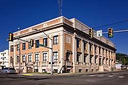 Lewis County Historic Courthouse | |
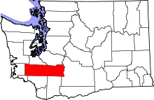 Location in the U.S. state of Washington | |
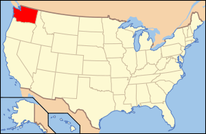 Washington's location in the U.S. | |
| Founded | 19 December, 1845 |
| Named for | Meriwether Lewis |
| Seat | Chehalis |
| Largest city | Centralia |
| Area | |
| • Total | 2,436 sq mi (6,309 km2) |
| • Land | 2,403 sq mi (6,224 km2) |
| • Water | 33 sq mi (85 km2), 1.4% |
| Population (est.) | |
| • (2017) | 78,200 |
| • Density | 32.5/sq mi (12.5/km2) |
| Congressional district | 3rd |
| Time zone | Pacific: UTC−8/−7 |
| Website |
www |
Lewis County is a county in the U.S. state of Washington. As of the 2010 census, the county's population was 75,455.[1] The county seat is Chehalis,[2] and its largest city is Centralia. The county was created as Vancouver County on 19 December 1845, by the Provisional Government of Oregon,[3] named for George Vancouver. In 1849, the county name was changed, to honor Meriwether Lewis.[4] At the time, the county included all U.S. lands north of the Cowlitz River, including much of the Puget Sound region and British Columbia.[5]
Lewis County comprises the Centralia, WA Micropolitan Statistical Area, which is also included in the Seattle-Tacoma, WA Combined Statistical Area.
Geography and natural features
According to the U.S. Census Bureau, the county has a total area of 2,436 square miles (6,310 km2), of which 2,403 square miles (6,220 km2) is land and 33 square miles (85 km2) (1.4%) is water.[6] One of the world's tallest Douglas fir trees was in the town of Mineral within Lewis County, attaining a height of 120 metres (390 ft).[7]
Geographic features
- Cascade Mountains
- Chehalis River
- Cowlitz River
- Nisqually River
- Lake Mayfield
- Riffe Lake
- Big Horn, the highest point in Lewis county
- Boistfort Peak, the highest point in the Willapa Hills
- Walupt Creek Falls
Major highways
Adjacent counties
- Grays Harbor County – north/northwest
- Thurston County – north
- Pierce County – north/northeast
- Yakima County – east
- Skamania County – south/southeast
- Cowlitz County – south
- Wahkiakum County – south/southwest
- Pacific County – west
National protected areas
Demographics
| Historical population | |||
|---|---|---|---|
| Census | Pop. | %± | |
| 1850 | 558 | — | |
| 1860 | 384 | −31.2% | |
| 1870 | 888 | 131.3% | |
| 1880 | 2,600 | 192.8% | |
| 1890 | 11,499 | 342.3% | |
| 1900 | 15,157 | 31.8% | |
| 1910 | 32,127 | 112.0% | |
| 1920 | 36,840 | 14.7% | |
| 1930 | 40,034 | 8.7% | |
| 1940 | 41,393 | 3.4% | |
| 1950 | 43,755 | 5.7% | |
| 1960 | 41,858 | −4.3% | |
| 1970 | 45,467 | 8.6% | |
| 1980 | 56,025 | 23.2% | |
| 1990 | 59,358 | 5.9% | |
| 2000 | 68,600 | 15.6% | |
| 2010 | 75,455 | 10.0% | |
| Est. 2017 | 78,200 | [8] | 3.6% |
| U.S. Decennial Census[9] 1790–1960[10] 1900–1990[11] 1990–2000[12] 2010–2016[1] | |||
2000 census
As of the 2000 census,[13] there were 68,600 people, 26,306 households, and 18,572 families in the county. The population density was 28 people per square mile (11/km²). There were 29,585 housing units at an average density of 12 per square mile (5/km²). The racial makeup of the county was 92.96% White, 0.38% Black or African American, 1.22% Native American, 0.69% Asian, 0.18% Pacific Islander, 2.55% from other races, and 2.01% from two or more races. 5.37% of the population were Hispanic or Latino of any race. 18.7% were of German, 11.8% United States or American, 11.1% English, 8.7% Irish and 5.7% Norwegian ancestry.
There were 26,306 households, 31.60% of which had resident children under age 18, 55.90% were married couples living together, 9.90% had a female householder with no husband present, and 29.40% were non-families. 24.00% of households were made up of individuals and 11.20% had someone living alone who was 65 years of age or older. The average household size was 2.57 and the average family size was 3.02.
The age distribution of the county's population: 26.50% under age 18, 8.20% from 18 to 24, 25.20% from 25 to 44, 24.50% from 45 to 64, and 15.50% at or over age 65. The median age was 38 years. For every 100 females there were 98.30 males. For every 100 females age 18 and over, there were 95.40 males.
The median income for a household in the county was $35,511, and the median income for a family was $41,105. Males had a median income of $35,714 versus $23,453 for females. The per capita income for the county was $17,082. About 10.40% of families and 14.00% of the population were below the poverty line, including 18.60% of those under age 18 and 9.40% of those age 65 or over.
2010 census
As of the 2010 United States Census, there were 75,455 people, 29,743 households, and 20,104 families residing in the county.[14] The population density was 31.4 inhabitants per square mile (12.1/km2). There were 34,050 housing units at an average density of 14.2 per square mile (5.5/km2).[15] The racial makeup of the county's population: 89.7% white, 1.4% American Indian, 0.9% Asian, 0.5% black or African American, 0.2% Pacific islander, 4.0% from other races, and 3.2% from two or more races. Those of Hispanic or Latino origin made up 8.7% of the population.[14] In terms of ancestry, 24.1% were German, 14.9% were Irish, 12.5% were English, 7.7% were American, and 5.1% were Norwegian.[16]
Of the 29,743 households, 30.2% had children under the age of 18 living with them, 51.2% were married couples living together, 10.9% had a female householder with no husband present, 32.4% were non-families, and 25.7% of all households were made up of individuals. The average household size was 2.51 and the average family size was 2.97. The median age was 41.5 years.[14]
The median income for a household in the county was $43,874 and the median income for a family was $53,358. Males had a median income of $43,695 versus $31,720 for females. The per capita income for the county was $21,695. About 10.3% of families and 13.3% of the population were below the poverty line, including 18.2% of those under age 18 and 8.6% of those age 65 or over.[17]
Government and politics
National level
Lewis County is arguably the most conservative county in western Washington. It is significantly more Republican than adjacent counties, with the possible exception of Yakima County. Unlike much of western Washington, it has a strong tinge of social conservatism. In 2000 George W. Bush received over 60% of the county’s vote. In 2008 John McCain defeated Barack Obama by over eighteen percent — his only victory in a county west of the Cascades. McCain lost all the neighboring counties except Yakima. The Republican candidate has won by over ten percent in every Presidential election since 1992.[18] Since Washington’s statehood in 1889 only two Democratic Presidential candidates have carried the county – Franklin Delano Roosevelt three times in 1932, 1936 and 1940, plus Lyndon Johnson in 1964.[19] As part of Washington’s Third Congressional District it is represented by Republican Congresswoman Jaime Herrera Beutler since 2011.
| Year | Republican | Democratic | Third parties |
|---|---|---|---|
| 2016 | 62.5% 21,992 | 27.4% 9,654 | 10.1% 3,553 |
| 2012 | 59.6% 20,452 | 36.9% 12,664 | 3.5% 1,204 |
| 2008 | 58.0% 20,278 | 39.0% 13,624 | 3.1% 1,067 |
| 2004 | 64.9% 21,042 | 33.1% 10,726 | 2.0% 660 |
| 2000 | 61.9% 18,565 | 33.0% 9,891 | 5.1% 1,530 |
| 1996 | 47.9% 13,238 | 37.4% 10,331 | 14.7% 4,075 |
| 1992 | 45.3% 12,316 | 28.8% 7,810 | 25.9% 7,042 |
| 1988 | 61.0% 14,184 | 37.1% 8,629 | 1.8% 425 |
| 1984 | 66.2% 15,846 | 31.9% 7,634 | 1.9% 451 |
| 1980 | 59.9% 13,636 | 30.6% 6,962 | 9.5% 2,151 |
| 1976 | 51.7% 10,933 | 42.6% 9,026 | 5.7% 1,208 |
| 1972 | 58.6% 12,071 | 33.7% 6,946 | 7.6% 1,568 |
| 1968 | 47.0% 8,779 | 45.2% 8,444 | 7.7% 1,445 |
| 1964 | 36.5% 6,933 | 63.5% 12,070 | 0.1% 19 |
| 1960 | 56.5% 11,012 | 43.2% 8,411 | 0.3% 57 |
| 1956 | 60.7% 11,949 | 39.2% 7,714 | 0.1% 25 |
| 1952 | 62.8% 12,287 | 36.4% 7,115 | 0.9% 169 |
| 1948 | 50.4% 9,047 | 46.8% 8,394 | 2.9% 512 |
| 1944 | 53.2% 8,896 | 46.1% 7,706 | 0.7% 124 |
| 1940 | 49.3% 9,228 | 49.6% 9,280 | 1.2% 218 |
| 1936 | 35.2% 5,885 | 57.6% 9,619 | 7.2% 1,201 |
| 1932 | 29.8% 4,647 | 54.2% 8,454 | 16.0% 2,493 |
| 1928 | 71.1% 9,253 | 27.6% 3,591 | 1.3% 166 |
| 1924 | 58.1% 6,973 | 12.9% 1,544 | 29.1% 3,490 |
| 1920 | 54.6% 6,160 | 19.6% 2,212 | 25.8% 2,913 |
| 1916 | 48.9% 5,186 | 40.7% 4,318 | 10.4% 1,097 |
| 1912 | 32.7% 3,200 | 25.3% 2,471 | 42.1% 4,115[21] |
| 1908 | 60.5% 3,170 | 26.9% 1,412 | 12.6% 662 |
| 1904 | 69.9% 3,098 | 20.2% 896 | 9.8% 436 |
| 1900 | 55.4% 1,907 | 40.2% 1,382 | 4.5% 153 |
| 1896 | 48.4% 1,594 | 50.2% 1,654 | 1.5% 49 |
| 1892 | 41.5% 1,350 | 31.2% 1,014 | 27.4% 890 |
Gubernatorial races
In the 1970s, Democratic candidates for governor won the county, but this was something of an anomaly. The last Democratic candidate for Governor to win the county was Booth Gardner in 1984.[22]
State representation
The county’s government is the 20th district of the state. It is represented solely by Republicans.[23]
- Senator John Braun—Republican
- Representative Richard DeBolt—Position 1, Republican
- Representative Ed Orcutt—Position 2, Republican
County level
The county’s government is solely Republican.
- Lewis County Assessor: Dianne Dorey—R
- Lewis County Auditor: Larry E. Grove—R
- Lewis County Clerk: Scott Tinney—R
- Coroner Warren Mcleod—R
- Lewis County Prosecuting Attorney: Jonathan Meyer—R
- Lewis County Sheriff: Rob Snaza—R
- Lewis County Treasurer: Arny Davis—R
- Edna Fund, District #1 – Republican
- Bobby Jackson, District #2 – Republican
- Gary Stamper, District #3 – Republican
Communities
Cities
Town
Census-designated places
Unincorporated communities
- Adna
- Alpha
- Boistfort
- Bunker
- Ceres
- Cinebar
- Curtis
- Doty
- Dryad
- Ethel
- Evaline
- Galvin
- Glenoma
- Harmony
- Klaber
- Kosmos (former - now under Riffe Lake)
- Lacamas
- Littell
- Marys Corner
- Nesika (former, now inundated by S edge of Riffe Lake)
- Newaukum
- Randle
- Riffe (former, now inundated by Riffe Lake)
- Saint Urban
- Salkum
- Silver Creek
- Wildwood
See also
References
- 1 2 "State & County QuickFacts". United States Census Bureau. Archived from the original on 13 July 2011. Retrieved 7 January 2014.
- ↑ "Find a County". National Association of Counties. Retrieved 7 June 2011.
- ↑ "Milestones for Washington State History — Part 1: Prehistory to 1850". HistoryLink.org. 5 March 2003.
- ↑ Oregon Spectator (Oregon City OR), "Name of Counties Changed", 18 October 1849, p. 3. Online at the University of Oregon Digital Archives
- ↑ "Action Bringing Lewis County Goes Back A Total of 115 Years". The Daily Chronicle. June 6, 1953. p. 10B. Retrieved July 26, 2018 – via Newspapers.com.

- ↑ "2010 Census Gazetteer Files". United States Census Bureau. 22 August 2012. Retrieved 7 July 2015.
- ↑ C. Michael Hogan (2008) Douglas-fir: Pseudotsuga menziesii, globalTwitcher.com, ed. Nicklas Strõmberg Archived 4 June 2009 at the Wayback Machine.
- ↑ "Population and Housing Unit Estimates". Retrieved 4 April 2018.
- ↑ "U.S. Decennial Census". United States Census Bureau. Retrieved 7 January 2014.
- ↑ "Historical Census Browser". University of Virginia Library. Retrieved 7 January 2014.
- ↑ "Population of Counties by Decennial Census: 1900 to 1990". United States Census Bureau. Retrieved 7 January 2014.
- ↑ "Census 2000 PHC-T-4. Ranking Tables for Counties: 1990 and 2000" (PDF). United States Census Bureau. Retrieved 7 January 2014.
- ↑ "American FactFinder". United States Census Bureau. Retrieved 14 May 2011.
- 1 2 3 "DP-1 Profile of General Population and Housing Characteristics: 2010 Demographic Profile Data". United States Census Bureau. Retrieved 6 March 2016.
- ↑ "Population, Housing Units, Area, and Density: 2010 – County". United States Census Bureau. Retrieved 6 March 2016.
- ↑ "DP02 SELECTED SOCIAL CHARACTERISTICS IN THE UNITED STATES – 2006–2010 American Community Survey 5-Year Estimates". United States Census Bureau. Retrieved 6 March 2016.
- ↑ "DP03 SELECTED ECONOMIC CHARACTERISTICS – 2006–2010 American Community Survey 5-Year Estimates". United States Census Bureau. Retrieved 6 March 2016.
- ↑ The New York Times Electoral Map (zoom in on Washington state)
- ↑ Menendez, Albert J.; The Geography of Presidential Elections in the United States, 1868–2004, pp. 332–334 ISBN 0786422173
- ↑ Leip, David. "Dave Leip's Atlas of U.S. Presidential Elections". uselectionatlas.org. Retrieved 6 April 2018.
- ↑ The leading "other" candidate, Progressive Theodore Roosevelt, received 2,032 votes, while Socialist candidate Eugene Debs received 1,637 votes, Prohibition candidate Eugene Chafin received 410 votes, and Socialist Labor candidate Arthur Reimer received 36 votes.
- ↑ David Leip’s US Election Atlas
- ↑ Lewis County, Democrats Archived 3 July 2008 at the Wayback Machine.
Further reading
- Ware, Louisa Jackson (1865). Daily journal of Louisa Jackson, 1865. Available online through the Washington State Library's Classics in Washington History collection Daily diary for the entire year of 1865, recording the details of pioneer life in Washington Territory from the perspective of a 12-year-old girl who was part of a prominent Lewis County family. Brief entries document the activities of running the farm and the number of visitors and immigrants that stopped at the Jackson home.
- Early history of Lewis County on Drizzle.com
46°35′N 122°24′W / 46.58°N 122.40°WCoordinates: 46°35′N 122°24′W / 46.58°N 122.40°W
External links
Places adjacent to Lewis County, Washington | ||||||||||
|---|---|---|---|---|---|---|---|---|---|---|
| ||||||||||
Municipalities and communities of Lewis County, Washington, United States | ||
|---|---|---|
| Cities | | |
| Town | ||
| CDPs | ||
| Other unincorporated communities | ||
| Ghost towns | ||
