Lipen Glacier
| Lipen Glacier | |
|---|---|
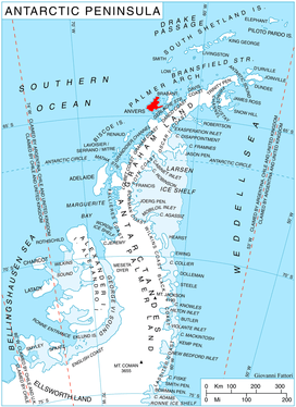 Location of Anvers Island in the Antarctic Peninsula region | |
 Location of Lipen in Antarctica | |
| Location | Palmer Archipelago |
| Coordinates | 64°29′15″S 63°16′30″W / 64.48750°S 63.27500°W / -64.48750; -63.27500 |
| Length | 3 nmi (6 km; 3 mi) |
| Width | 2 nmi (4 km; 2 mi) |
| Thickness | unknown |
| Terminus | Patagonia Bay |
| Status | unknown |
Lipen Glacier (Bulgarian: ледник Липен, ‘Lednik Lipen’ \'led-nik 'li-pen\) is a 5 km long and 3.5 km wide glacier draining the east slopes of the Trojan Range on Anvers Island in the Palmer Archipelago, Antarctica. Situated east of Iliad Glacier and north of Rhesus Glacier. Flowing northeastwards into the head of Patagonia Bay east of Gourdon Peninsula and west of Thompson Peninsula.
The glacier is named after the settlement of Lipen in northwestern Bulgaria.
Location
Lipen Glacier is centred at 64°29′15″S 63°16′30″W / 64.48750°S 63.27500°W / -64.48750; -63.27500Coordinates: 64°29′15″S 63°16′30″W / 64.48750°S 63.27500°W / -64.48750; -63.27500. British mapping in 1980.
See also
Maps
- British Antarctic Territory. Scale 1:200000 topographic map No. 3217. DOS 610 - W 64 62. Tolworth, UK, 1980.
- Antarctic Digital Database (ADD). Scale 1:250000 topographic map of Antarctica. Scientific Committee on Antarctic Research (SCAR), 1993–2016.
References
- Bulgarian Antarctic Gazetteer. Antarctic Place-names Commission. (details in Bulgarian, basic data in English)
- SCAR Composite Antarctic Gazetteer
This article includes information from the Antarctic Place-names Commission of Bulgaria which is used with permission.
| Types | |||||||
|---|---|---|---|---|---|---|---|
| Anatomy | |||||||
| Processes | |||||||
| Measurements | |||||||
| Volcanic relations | |||||||
| Landforms |
| ||||||
| |||||||