Christensen Glacier (Bouvet Island)
| Christensen Glacier | |
|---|---|
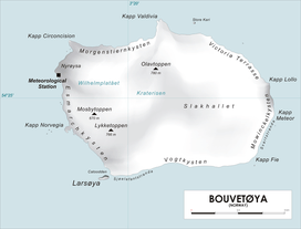 Map of Bouvetøya | |
| Location | Bouvet Island |
| Coordinates | 54°28′S 3°24′E / 54.467°S 3.400°E / -54.467; 3.400 |
| Thickness | unknown |
| Terminus | east of Cato Point |
| Status | unknown |
Christensen Glacier is a glacier which flows to the south coast of the island of Bouvetøya, 1 nautical mile (2 km) east of Cato Point. It was first charted in 1898 by a German expedition under Carl Chun, and recharted in December 1927 by a Norwegian expedition under Captain Harald Horntvedt. It was named by Horntvedt after Lars Christensen, the sponsor of the expedition.[1][2] [3][4]
See also
References
- ↑ "Christensen Glacier". Geographic Names Information System. United States Geological Survey. Retrieved 2011-11-11.
- ↑ Susan Barr. "Bouvetøya". Store norske leksikon. Retrieved October 1, 2016.
- ↑ "Prof. Dr. phil., Dr. med. h. c. Carl Chun". University of Leipzig. Retrieved October 1, 2016.
- ↑ "Christensen Glacier, Antarctica". Geographical Names. Retrieved 24 January 2018.
![]()
Coordinates: 54°28′S 3°24′E / 54.467°S 3.400°E / -54.467; 3.400
| Types | |||||||
|---|---|---|---|---|---|---|---|
| Anatomy | |||||||
| Processes | |||||||
| Measurements | |||||||
| Volcanic relations | |||||||
| Landforms |
| ||||||
| |||||||
This article is issued from
Wikipedia.
The text is licensed under Creative Commons - Attribution - Sharealike.
Additional terms may apply for the media files.