Palmer Archipelago
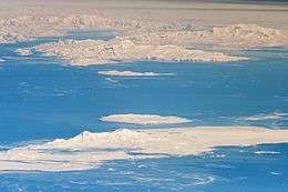 Hoseason, Liege, Brabant and Anvers Islands shown behind Livingston and Deception Islands of the South Shetland Islands | |
 Map of Palmer Archipelago, showing its location in Antarctica | |
| Geography | |
|---|---|
| Location | Antarctica |
| Coordinates | 64°15′S 62°50′W / 64.250°S 62.833°WCoordinates: 64°15′S 62°50′W / 64.250°S 62.833°W |
| Administration | |
| Administered under the Antarctic Treaty System | |
| Demographics | |
| Population | Data not available |


Palmer Archipelago, also known as Antarctic Archipelago, Archipiélago Palmer, Antarktiske Arkipel or Palmer Inseln, is a group of islands off the northwestern coast of the Antarctic Peninsula. It extends from Tower Island in the north to Anvers Island in the south. It is separated by the Gerlache and Bismarck straits from the Antarctic Peninsula and Wilhelm Archipelago, respectively.[1]
Palmer Archipelago is located at 64°15′S 62°50′W / 64.250°S 62.833°W.
History
Adrien de Gerlache, leader of the Belgian Antarctic Expedition (1897–1899), discovered the archipelago in 1898. He named it Archipelago Palmer for American Captain Nathaniel Palmer, who navigated these waters in 1820.[1]
Both Argentina and the United Kingdom have operated research stations there.
Islands
The archipelago includes:
- Abbott Island
- Alpha Island
- Anvers Island
- Auguste Island
- Brabant Island
- Bremen Island
- Buff Island
- Chukovezer Island
- Cobalcescou Island
- Cormorant Island
- Davis Island
- Delta Island
- Dink Island
- Doumer Island
- Dream Island
- Emen Island
- Eta Island
- Gand Island
- Halfway Island
- Hermit Island
- Hoseason Island
- Humble Island
- Imelin Island
- Janus Island
- Kalotina Island
- Lambda Island
- Lapteva Island
- Lecointe Island
- Litchfield Island
- Liège Island
- Masteyra Island
- Ohlin Island
- Omega Island
- Pabellon Island
- Pampa Island
- Petrelik Island
- Raklitsa Island
- Rogulyat Island
- Soatris Island
- Spert Island
- Spume Island
- Temenuga Island
- Torgersen Island
- Tower Island
- Trebishte Island
- Trinity Island
- Tripod Island
- Two Hummock Island
- Vromos Island
- Walsham Rocks
- Wiencke Island
- Yoke Island
- Zigzag Island
See also
References
- 1 2 "Palmer Archipelago: Antarctica". Geographic.org. Retrieved 2011-12-31.
External links
![]()