Byrd Glacier
See also: Byrdbreen
| Byrd Glacier | |
|---|---|
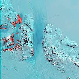 Byrd Glacier from Landsat | |
 Location of Byrd Glacier in Antarctica | |
| Location | Ross Dependency |
| Coordinates | 80°20′S 159°00′E / 80.333°S 159.000°E / -80.333; 159.000 |
| Length | 136 km (85 mi) |
| Width | 24 km (15 mi) |
| Thickness | unknown |
| Terminus | Ross Ice Shelf |
| Status | unknown |
The Byrd Glacier is a major glacier in Antarctica, about 136 km long and 24 km wide, draining an extensive area of the polar plateau and flowing eastward between the Britannia Range and Churchill Mountains to discharge into the Ross Ice Shelf at Barne Inlet. Its valley below the glacier is the lowest point not to covered by water on Earth which reaches 2,780 m (9,121 feet) below sea level.[1] It was Named by the NZ-APC after Rear Admiral Byrd, US Navy, American Antarctic explorer.
See also
References
- ↑ "About - British Antarctic Survey". www.bas.ac.uk. Archived from the original on 26 September 2015. Retrieved 30 April 2018.
Coordinates: 80°20′S 159°00′E / 80.333°S 159.000°E / -80.333; 159.000
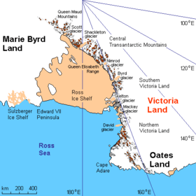
Area map of Byrd glacier.
| Types | |||||||
|---|---|---|---|---|---|---|---|
| Anatomy | |||||||
| Processes | |||||||
| Measurements | |||||||
| Volcanic relations | |||||||
| Landforms |
| ||||||
| |||||||
This article is issued from
Wikipedia.
The text is licensed under Creative Commons - Attribution - Sharealike.
Additional terms may apply for the media files.