Iskar Glacier
| Iskar Glacier | |
|---|---|
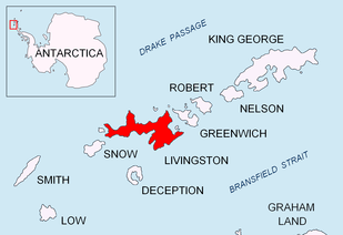 Location of Livingston Island in the South Shetland Islands | |
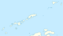 Location of Iskar Glacier in Antarctica  Iskar Glacier (Antarctica) | |
| Location | Livingston Island |
| Coordinates | 62°38′20″S 59°59′20″W / 62.63889°S 59.98889°W |
| Thickness | unknown |
| Terminus | Bruix Cove |
| Status | unknown |
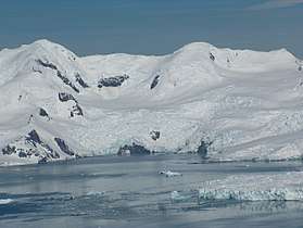

Iskar Glacier (Iskarski Lednik \'is-k&r-ski 'led-nik\) is a glacier in Livingston Island, South Shetland Islands in Antarctica situated southeast of lower Huron Glacier, west-southwest of Sopot Ice Piedmont, and north of Dobrudzha and Magura Glaciers. It drains the north slopes of the Tangra Mountains between Helmet Peak to the west and Delchev Peak to the east, and flows northward into Bruix Cove between Yana Point and Rila Point.
The feature is named after the Iskar River in western Bulgaria.
Location
Iskar Glacier is centred at 62°38′20″S 59°59′20″W / 62.63889°S 59.98889°WCoordinates: 62°38′20″S 59°59′20″W / 62.63889°S 59.98889°W. Bulgarian mapping in 2005 and 2009.
See also
Maps
- L.L. Ivanov et al. Antarctica: Livingston Island and Greenwich Island, South Shetland Islands. Scale 1:100000 topographic map. Sofia: Antarctic Place-names Commission of Bulgaria, 2005.
- L.L. Ivanov. Antarctica: Livingston Island and Greenwich, Robert, Snow and Smith Islands. Scale 1:120000 topographic map. Troyan: Manfred Wörner Foundation, 2009.
References
- Iskar Glacier. SCAR Composite Antarctic Gazetteer.
- Bulgarian Antarctic Gazetteer. Antarctic Place-names Commission. (details in Bulgarian, basic data in English)
This article includes information from the Antarctic Place-names Commission of Bulgaria which is used with permission.
![]()